
Jammu and Kashmir was a region formerly administered by India as a state from 1952 to 2019, constituting the southern and southeastern portion of the larger Kashmir region, which has been the subject of a dispute between India, Pakistan and China since the mid-20th century. The underlying region of this state were parts of the former princely state of Jammu and Kashmir, whose western districts, now known as Azad Kashmir, and northern territories, now known as Gilgit-Baltistan, are administered by Pakistan. The Aksai Chin region in the east, bordering Tibet, has been under Chinese control since 1962.

Baramulla district or Varmul is one of the 20 districts in the Indian-administered union territory of Jammu and Kashmir (J&K) in the disputed Kashmir region. Baramulla town is the administrative headquarters of this district. The district covered an area of 4,588 km2 (1,771 sq mi) in 2001, but it was reduced to 4,243 km2 (1,638 sq mi) at the time of 2011 census. In 2016, the district administration said that the area was 4,190 km2 (1,620 sq mi). Muslims constitute about 98% of the population.

Udhampur (ˌʊd̪ʱəmpur) is a city and a municipal council in Udhampur district in the Indian union territory of Jammu and Kashmir. It is the headquarters of Udhampur District. Named after Raja Udham Singh, it serves as the district capital and the Northern Command headquarters of the Indian Army. A Forward Base Support Unit (FBSU) of the Indian Air Force is also stationed here. Udhampur is used by the Armed Forces as a transit point between Jammu and Srinagar when travelling by road on National Highway 1A, which has since been renamed as National Highway 44.

Doda district is an administrative district of the Jammu division of Indian-administered Jammu and Kashmir in the disputed Kashmir region. Doda covers 2,625 square kilometers.
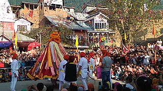
Bhaderwah or Bhadarwah is a town, tehsil, and sub-district in the Doda district of Jammu Division of Jammu and Kashmir, India. Bhaderwah Valley is famous for it's beauty, nature. Bhaderwah valley is known as 'Land Of Snakes'. Bhaderwah is also a land of fairs and festivals like Mela Pat, Subar Dhar Mela, Kud dance, Pahari folk songs and music. It also has heritage sites like the Fort, hundered years old mosque and an ancient Vasuki Nag Temple.

Udhampur is an administrative district in the Jammu division of Indian-administered Jammu and Kashmir in the disputed Kashmir region. Covering an area of 4,550 square kilometres (1,760 sq mi) in the Himalayan mountains, the district has its headquarters in the town of Udhampur. The Northern Command headquarters of the Indian Army is located in the district.
Batote is a town and a notified area committee, near Ramban town in Ramban district of Indian union territory of Jammu and Kashmir on NH 44 just beyond Ramban, Patnitop while going towards Srinagar.
Chanani or Chenani is a town and tehsil in the Udhampur district, in the Indian union territory of Jammu and Kashmir. It is governed by a notified area council. Before 1947, it was an internal jagir ruled by a Chandel (Rajput) ruler in the princely state of Jammu and Kashmir. This Town has further gained importance after getting the Asia's longest tunnel from chenani to nasari.

Kishtwar is a town, municipality and administrative headquarter of the Kishtwar district in the Indian-administered Jammu and Kashmir. The district was carved out of the Doda district in 2007. and is located in the Jammu division. The town of Kishtwar is situated at a distance of 209.5 km (130.2 mi) from the summer capital of Srinagar, and 211.5 km (131.4 mi) from the winter capital of Jammu. A large ground locally called as Chowgan ground is located in the heart of the town.
Kud is a town and a notified area committee in Udhampur district in the Indian union territory of Jammu and Kashmir. It is about 10 km from the popular tourist place Patnitop and is famous for a local sweet known as "Desi Ghee Patisa" another name of the sweet made up of milk products. Desi Ghee is a milk product and patisa is known as Papdi.

Samba is a town, municipal committee, and administrative headquarter of Samba district of the Indian-administered Jammu and Kashmir in the disputed Kashmir region. Samba has his own railway station are Samba railway station on Jammu-Delhi railway line.

Reasi district is an administrative district in the Jammu division of Indian state of Jammu and Kashmir in the Jammu region. The Reasi district is bordered by Udhampur district and Ramban district in the east, Jammu district in the south, Rajouri district in the west and by Kulgam district on the north. The Reasi and Rajouri tehsils formed a joint district called the "Reasi district" at the time of the princely state's accession to India in 1947. As part of the reorganisation, the two tehsils were separated and Reasi was merged with the Udhampur district. It again became a separate district in 2006.
Nagrota is a town located in the Jammu district of Jammu and Kashmir in India. It is located on National highway 44 between Jammu city and Udhampur. It is situated on the bank of River Tawi. Nagrota along with Kashmiri Pandit Migrant town of Jagti straddle the national highway. Nagrota is the first shrine stoppage for Shri Mata Vaishno Devi. The Kol-Kandoli temple is a mandate for completing the Shri Mata Vaishno Devi pilgrimage. Nagrota has an extension of Jammu Industries having Oil Depots and Godowns.It serves as headquarter of the XVI Corps (India) also known as the 'White Knight Corp'.
Ramban district is an administrative district in the Jammu division of Indian-administered Jammu and Kashmir in the disputed Kashmir region. It is located in a valley surrounded the Pir Panjal range. It was carved out as a separate district from erstwhile Doda district in 2007. It is located in the Jammu division. The district headquarters are at Ramban town, which is located midway between Jammu and Srinagar along the Chenab river in the Chenab valley on National Highway-44, approximately 151 km from Jammu and Srinagar.

Kishtwar district is an administrative district of the Jammu division of Indian-administered Jammu and Kashmir of the disputed Kashmir region. As of 2011, it is the largest and the least populous district of the Union Territory of Jammu and Kashmir.

Chenab Valley is a loosely-defined controversial term sometimes used to refer to parts of the Jammu Division of Jammu and Kashmir, India. It is used to refer to the present-day districts of Doda, Kishtwar, Ramban. These three districts used to be part of a single former district called Doda, which was created in 1948 out of the eastern parts of Udhampur district of the princely state of Jammu and Kashmir, and are sometimes collectively referred to as the Doda belt. The term is seen to be aimed at a communal break-up of the Jammu Division and iteration of Kashmiri Muslim irredentism.

Jammu and Kashmir is a region administered by India as a union territory and consists of the southern portion of the larger Kashmir region, which has been the subject of a dispute between India and Pakistan since 1947 and between India and China since 1959. The Line of Control separates Jammu and Kashmir from the Pakistani-administered territories of Azad Kashmir and Gilgit-Baltistan in the west and north. It lies to the north of the Indian states of Himachal Pradesh and Punjab and to the west of Ladakh which is administered by India as a union territory.
Dudu is a village and municipality in Udhampur district of the Indian union territory of Jammu and Kashmir. The town is located 100 kilometres from the district headquarters Udhampur.
Ghordi Khas is a village located in Udhampur district, Jammu and Kashmir, India.
Amara is a village in Udhampur district, Jammu & Kashmir, India. It is 15 km (9.3 mi) from Majalta tehsil.

