
Doda is a town and a notified area committee in Doda district in the Indian union territory of Jammu and Kashmir. Doda has an average elevation of 1,107 metres (3,632 ft).

Ganderbal is a town and a municipality committee in Ganderbal district in the Indian union territory of Jammu and Kashmir. It is the headquarters of Ganderbal district.It is in Central Kashmir, it has an average elevation of 1,619 metres. It is bordered by district Srinagar in the south, Bandipore to the north, Kargil in the northeast, Anantnag to the south-east and Baramulla in the south-west.The current District Magistrate of Ganderbal is Mr. Shyambir Singh.District Ganderbal is known for its beauty,there are many beautiful places in Ganderbal.Sonmarg is the most famous place in Ganderbal, Shri Amarnath Ji Yatra is also done in Ganderbal.
Nowshera is a town and the headquarters of an eponymous tehsil of Rajouri district in the Jammu division of the Indian Union Territory of Jammu and Kashmir. It is governed by a Municipal committee and in rural area of Nowshera consists of 14 panchayats governed by local bodies under the supervision of district administration Rajouri.
Sunderbani is a town and a notified area committee, about 70 km from Rajouri Town in Rajouri district in the Indian union territory of Jammu and Kashmir.
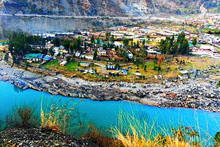
Ramban is a town in Ramban district of Jammu and Kashmir, India, which is the district headquarters of Ramban district. It lies on the banks of the Chenab river in Chenab Valley on the National Highway-1A at about 120 km from Jammu and about 130 km from Srinagar, making it almost the central point on the Jammu-Srinagar National Highway.
Chack Diyalla or Chakdyala is a village in the Indian union territory of Jammu and Kashmir. It is located in Hiranagar tehsil of Kathua district.
Ari is a village situated in Poonch district of Jammu and Kashmir, India. It is one of the largest villages in Jammu and Kashmir. It is located approximately 2 kilometers away from Mendhar Tehsil and 44 kilometers away from Poonch district
Ajas is a village and tehsil located in Bandipora district of the Indian administered union territory of Jammu and Kashmir. The village is located at a distance of 21 kilometres from the district headquarters Bandipore. The village is situated on the banks of the famous and largest freshwater lake of India, the Wular Lake. Its circumference is partly bound by huge mountains and dense green forests. The is one of the wildlife area and only one wildlife range in Bandipora. There are hundreds of Wild Animals like, Leopard, Black Bear, Mask Dear and many other Wild Animals. A large stream flows through the village and is called the "BudKul".
Kralpora is a Tehsil and a village in Kupwara district of the Indian administered union territory of Jammu and Kashmir. The village is located just 15 kilometres from district headquarters Kupwara town.
Dawar is a village in Gurez Tehsil in Bandipora district of Jammu and Kashmir.
Gundna is a village in Doda district of the Indian union territory of Jammu and Kashmir. The village is located just 40 kilometres from the district headquarters Doda.
Bhagwa or Bhagwah is a Tehsil in Doda district of the Indian union territory of Jammu and Kashmir. The town is located 14 kilometres from the district headquarters Doda.
Dudu is a village and municipality in Udhampur district of the Indian union territory of Jammu and Kashmir. The town is located 100 kilometres from the district headquarters Udhampur.
Pouni is a village and municipality in Reasi district of the Indian union territory of Jammu and Kashmir. The town is located 25 km from the district headquarters Reasi Town.
Azmatabad is a village, near Rajouri City in Thanamandi tehsil in Rajouri district of the Indian union territory of Jammu and Kashmir.
Ghagwal is a town and Panchayat in Samba district in the Jammu division of the Indian union territory of Jammu and Kashmir. The town is located 15 kilometres from district headquarters Samba. River Baein flows from east side of Ghagwal. Famous 1750 years old, Narsingh Dham Mandir is situated in Middle of Ghagwal and is also known as "Heart of Ghagwal". Before 2006 Ghagwal was part of Kathua District of Jammu Division. Ghagwal Town is Also Headquarter of Tehsil and Sub Division Office of Ghagwal. Govt. Degree College, Ghagwal is currently functional in Temporary Building.
Marh is a village and municipality in Jammu district of the Indian union territory of Jammu and Kashmir. The village is located 26 kilometres from district headquarters Jammu.

Markoot is a village in Gurez tehsil in Bandipora district of the Indian union territory of Jammu and Kashmir. It was part of ancient Dardistan and was divided in three parts; one among them is Gurez Valley, where the village Markoot lies. Markoot is located at the foot of the Habba Khatoon Mountain. Area-wise Markoot is the biggest village in whole Gurez valley. Markoot actually was ancient capital of Gurez valley.
Mankote is a village and tehsil in Poonch district of the Indian union territory of Jammu and Kashmir. The village is located 91 kilometres from the district headquarters in Poonch.
Ramkot is a village and tehsil in Kathua district of the Indian union territory of Jammu and Kashmir. The village is located about 80 kilometres from the district headquarter kathua.

