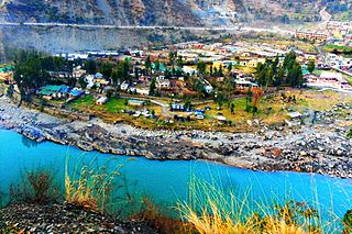
Doda is a town and a notified area committee in Doda district in the Indian union territory of Jammu and Kashmir. Doda has an average elevation of 1,107 metres (3,632 ft).
Batote is a town and a notified area committee, near Ramban town in Ramban district of Indian union territory of Jammu and Kashmir on NH 44 just beyond Ramban, Patnitop while going towards Srinagar.
Kulgam, known as Kolgom in Kashmiri, is a town, an administrative division and capital of the Kulgam district in the Indian union territory of Jammu and Kashmir. It is located at a distance of 67 km (42 mi) from the summer state capital of Jammu and Kashmir, Srinagar. The city is divided into 16 electoral wards that has a population of 23,584, of which 12,605 are males while 10,979 are females.

Ramban is a town in Ramban district of Jammu and Kashmir, India, which is the district headquarters of Ramban district. It lies on the banks of the Chenab river in Chenab Valley on the National Highway-1A at about 120 km from Jammu and about 130 km from Srinagar, making it almost the central point on the Jammu-Srinagar National Highway.
Bhimber Gali is a village in the Poonch district of Jammu and Kashmir, India. It is often called BG locally as an abbreviated form of Bhimber Gali. It is named after a mountain pass "Bhimber Gali" on the mountain ridge separating the Poonch River and the Rajouri Tawi basins. Bhimber Gali is the point at which four roads meet, one from Hamirpur Balakote, second from Rajouri via Manjakote, third from Mendhar Tehsil and fourth from Poonch Via Surankote. This area borders Pakistan administered Kashmir and thus the surrounding areas often remain in news for cross LoC ceasefire violations.
Dhargloon is a village, located in Mendhar Tehsil of Poonch district in Indian administered union territory of Jammu and Kashmir. Its district headquarters are located in Poonch and administrative units in "Mendhar"(temporarily). This village comes under the "Balakote" block which is its local administrative unit. The village is located close the border with Pakistan and is largely influenced by the border forces. Residents of Dhargaloon staged a protest in May 2017 because of water and power shortages.
Ari is a village situated in Poonch district of Jammu and Kashmir, India. It is one of the largest villages in Jammu and Kashmir. It is located approximately 5 kilometers away from Mendhar Tehsil and 44 kilometers away from Poonch district
Waripora Bangil is a village located in the town of Kunzer in the Baramulla district of the Indian-administered union territory of Jammu and Kashmir. It is situated 40 kilometres (25 mi) east of the district headquarters of Baramulla and about20 kilometres (12 mi) west of the capital city of Srinagar.
Teetwal is a small border-village in Jammu and Kashmir, India. It is situated on the banks of the Kishanganga River in Kupwara district, 82 km (51 mi) from the district headquarters of Kupwara and close to the Line of Control with Pakistani-administered Kashmir. Teetwal is connected to the rest of India via Tangdhar.
Ajas is a village and tehsil located in Bandipora district of the Indian administered union territory of Jammu and Kashmir. The village is located at a distance of 21 kilometres from the district headquarters Bandipore. The village is situated on the banks of the famous and largest freshwater lake of India, the Wular Lake. Its circumference is partly bound by huge mountains and dense green forests. The is one of the wildlife area and only one wildlife range in Bandipora. There are hundreds of Wild Animals like, Leopard, Black Bear, Mask Dear and many other Wild Animals. A large stream flows through the village and is called the "BudKul".
Nagam is a town and municipality in Budgam district of the Indian union territory of Jammu and Kashmir. The town is located 16 kilometres from district headquarters Budgam.
Wavoora is a village in Kupwara district of the Indian union territory of Jammu and Kashmir. The town is located 13 km (8.1 mi) from district headquarters Kupwara.
Duggan is a village and municipality in Kathua district of the Indian union territory of Jammu and Kashmir. The town is located 170 kilometres from the district headquarters Kathua & 15 Km From Tehsil Bani. Duggan is also a Block of Tehsil Bani with Large Area & Population. Duggan Village is Famous For "Shri Vasuki Naag Ji Maharaj Yatra".The Ancient Temple of Shri Vasuki Naag Ji Maharaj is Located here.
Bhagwah is a Tehsil in Doda district of the Indian union territory of Jammu and Kashmir. The town is located 14 kilometres from the district headquarters Doda.
Drabshalla is a village and municipality in Kishtwar district of the Indian union territory of Jammu and Kashmir. The town is located 22 kilometres from the district headquarters Kishtwar.
Dudu is a village and municipality in Udhampur district of the Indian union territory of Jammu and Kashmir. The town is located 100 kilometres from the district headquarters Udhampur.
Pouni is a village and municipality in Reasi district of the Indian union territory of Jammu and Kashmir. The town is located 25 km from the district headquarters Reasi Town.
Mandi is a village and municipality in Poonch district of the Indian union territory of Jammu and Kashmir. The town is located 20 km (12 mi) from the district headquarters Poonch.
Panchari is a village and municipality in Udhampur district of the Indian union territory of Jammu and Kashmir. The town is located 40 kilometres from the district headquarters Udhampur.
Marh is a village and municipality in Jammu district of the Indian union territory of Jammu and Kashmir. The village is located 26 kilometres from district headquarters Jammu.


