Kathua

Last updated

Kathua
City administered by India
Textile Park Kathua.png
Atal Setu near Kathua.png
Purthu artificial beach.png
Jasrota Fort.png
Clockwise from top: Atal Setu, Jasrota Fort, Industrial Estate
Atal Setu, Purthu Artificial Beach and Jasrota Fort in Kathua (J&K)
Kathua
Interactive map of Kathua
Kashmir region. LOC 2003626427 - showing Jammu division administered by India in neon blue.jpg
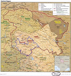
Kathua lies in the Jammu division (neon blue) of the Indian-administered Jammu and Kashmir (shaded in tan) in the disputed Kashmir region. [1]
Coordinates: 32°23′06″N75°31′01″E / 32.385°N 75.517°E / 32.385; 75.517
Administering country India
Union territory Jammu and Kashmir
District Kathua
Settled1025 BC [2]
Named for "KATHAI" [3]
Government
  Type Municipal Council
  BodyKathua Municipal Council (21) Seats
  Chairman Municipal CouncilNaresh Sharma (BJP)
Area
  Total28.32 km2 (10.93 sq mi)
Elevation
393 m (1,289 ft)
Population
 (2011)
  Total59,866
  Density3,765/km2 (9,750/sq mi)
Languages = Dogri & Hindi
Time zone UTC+5:30 (IST)
PIN
184101(HEAD OFFICE), 184104(Mini Secretariat)
Telephone code01922
Literacy86.46%
Website http://kathua.nic.in/
[4] [5] [6] [7]

Kathua is a city and municipal council of the Jammu division of Indian-administered Jammu and Kashmir in the disputed Kashmir region. [1] The city is the headquarters of Kathua district and is divided into 27 wards which constitute the Kathua Municipal Council. It is situated along NH-44 The city has a bustling industrial area and an army cantonment adjoining it. Being a transit hub for industrial activity in the state, the city has a large industrial base with textile park, Biotechnology and Pharma industrial and research park, Cement industry and many medium scale MSMEs. [4] [5] [6] [7]

Contents

Geography

Kathua is located at 32°22′N75°31′E / 32.37°N 75.52°E / 32.37; 75.52 . It has an average elevation of 393 metres (1,289 ft). The city is surrounded by three rivers. Ravi is 7 km (4.3 mi) down Kathua while Ujjh is about 11 km (6.8 mi) ahead on Jammu Highway. Kathua itself is situated along the banks of a khad which has been heavily polluted and encroached over there years and this has become a drain of sewage, dividing it into two boroughs: Parliwand, meaning the other side; and Orliwand, meaning this side. Itself being a Plain the area is surrounded in the North by snow-capped Sivalik hills. The large Ranjit Sagar Lake is 25 kms away and has a cooling effect on its climate. Kathua lies 88 kilometres south of Jammu. [8]

Demographics

Religion in Kathua City (2011) [9]

   Hinduism (91.34%)
   Sikhism (4.75%)
   Islam (2.68%)
   Christianity (1.09%)
   Buddhism (0.02%)
   Jainism (0.01%)
  Others (0.00%)
  Not Stated (0.13%)

Population

  • Total population of the Municipal Council and Outgrowth areas is 59,688 with 31,717 males and 28,149 females. The sex ratio is 888 women per 1000 men. There are 12,061 households in the Municipal Council and Outgrowth areas. [4] [5] [6]

Literacy

  • There are 46359 literates and 13,507 illiterates in the Municipal Council and Outgrowth areas resulting in an 86.46% literacy rate. The male and female literacy stand at 90.7% (25,605 indv.) and 81.75% (20,754) respectively. [4] [5] [6]

Language

Use of Urdu is predominant in official government documents along with English, but Dogri is the mother tongue and the vernacular language of the populace along with Hindi.

Religion

Hinduism is the largest religion in Kathua, followed by over 91% of the people. Sikhism is the second-largest religion with 4.75% adherents. Christianity and Islam form 1.09% and 2.68% of the population respectively. [9]

Climate

Kathua has a monsoon-influenced humid subtropical climate (Koppen Cwa). Kathua generally experiences extreme rainfall during the monsoon being on the windward side of Sivalik. Because of its proximity to rivers, the climate is moderate to very hot in summers and mild to very cold in winters. Summers are hot and the temperature may reach 37 degrees, while in winters, the temperature can dip to below 0 degrees at nights.

Heavy downpour is experienced during the monsoon season in July and August. The annual rainfall is around 1,700 millimetres (67 in), mainly in monsoons and winters. Heavy hailstorms may be experienced in February and March, but are very rare; Kathua does not experience snowfall. Fog and sometimes Smog occur regularly during the winters, especially in January and February.

Compared with Jammu, temperatures in Kathua remain fairly lower by 3-4 degrees. December and January can be very cold especially nights, while February to April and October- November remain pleasant and dry. August is generally humid and sometimes very uncomfortable. Winters are also wet due to frequent rains due to western disturbances. Late night thunderstorms are common while May is notorious for heavy dust storms.

Climate data for Kathua (1983–2010)
MonthJanFebMarAprMayJunJulAugSepOctNovDecYear
Record high °C (°F)30.4
(86.7)
28.6
(83.5)
36.8
(98.2)
43.6
(110.5)
44.8
(112.6)
48.0
(118.4)
42.5
(108.5)
39.0
(102.2)
38.8
(101.8)
39.6
(103.3)
32.2
(90.0)
28.5
(83.3)
48.0
(118.4)
Mean maximum °C (°F)23.7
(74.7)
26.0
(78.8)
31.6
(88.9)
36.1
(97.0)
37.0
(98.6)
36.1
(97.0)
36.3
(97.3)
35.9
(96.6)
35.2
(95.4)
29.1
(84.4)
30.0
(86.0)
25.3
(77.5)
36.3
(97.3)
Mean daily maximum °C (°F)18.1
(64.6)
21.6
(70.9)
26.5
(79.7)
31.1
(88.0)
34.1
(93.4)
35.3
(95.5)
32.1
(89.8)
29.2
(84.6)
30.8
(87.4)
30.5
(86.9)
26.5
(79.7)
21.0
(69.8)
28.1
(82.5)
Mean daily minimum °C (°F)2.5
(36.5)
7.1
(44.8)
13.0
(55.4)
17.9
(64.2)
22.6
(72.7)
24.6
(76.3)
24.1
(75.4)
23.8
(74.8)
22.1
(71.8)
16.6
(61.9)
11.3
(52.3)
3.7
(38.7)
15.8
(60.4)
Mean minimum °C (°F)2.3
(36.1)
4.7
(40.5)
8.5
(47.3)
12.1
(53.8)
17.5
(63.5)
20.4
(68.7)
20.6
(69.1)
20.6
(69.1)
18.1
(64.6)
12.5
(54.5)
7.5
(45.5)
3.1
(37.6)
2.3
(36.1)
Record low °C (°F)−1.8
(28.8)
0.2
(32.4)
5.6
(42.1)
9.2
(48.6)
14.4
(57.9)
17.6
(63.7)
14.0
(57.2)
14.0
(57.2)
11.5
(52.7)
7.4
(45.3)
3.6
(38.5)
0.0
(32.0)
−1.8
(28.8)
Average rainfall mm (inches)69.3
(2.73)
73.2
(2.88)
43.3
(1.70)
35.4
(1.39)
34.0
(1.34)
114.7
(4.52)
429.4
(16.91)
725.9
(28.58)
127.2
(5.01)
26.9
(1.06)
18.4
(0.72)
81.0
(3.19)
1,778.7
(70.03)
Average rainy days3.23.83.52.53.16.412.711.96.21.41.01.857.2
Average relative humidity (%)86807256476183878375808675
Source: India Meteorological Department [10]

Tourist attractions

Fort complex at Jasrota Compound Jasrota fort Kathua JammuKashmir India.jpg
Fort complex at Jasrota

[11] Kathua has also many small canals flowing throughout the town. [12] In addition to gardens and canals, the district of Kathua also contains historical landmarks such as Jasrota Fort, Jasmergarh Fort and Bhadu Fort.

Transport

Kathua is 80 km (50 mi) away from Jammu city and 120 km (75 mi) from Katra. Interstate and Intrastate road transport is easily accessible due to the close proximity to NH44. Jammu Airport is the nearest major airport with regular flights. The town is connected by Indian railways to all major cities of India. Intra-district transport is also easily available for travelling within the town and surrounding areas.

See also

Related Research Articles

<span class="mw-page-title-main">Srinagar district</span> District of Jammu and Kashmir, India

The Srinagar District is an administrative district of Indian-administered Jammu and Kashmir in the disputed Kashmir region. It is one of the 20 districts of Jammu and Kashmir. Situated in the centre of the Kashmir Valley, it is the second-most populous district of the union territory after Jammu District as per the 2011 national census, and is home to the summer capital city of Srinagar. Likewise, the city of Srinagar also serves as the Srinagar District's headquarters.

<span class="mw-page-title-main">Bhimber District</span> District in Azad Jammu and Kashmir, Pakistan

Bhimber District is a district of Pakistan-administered Azad Kashmir in the disputed Kashmir region. It is the southernmost of the 10 districts of Pakistan's territory of Azad Kashmir. It has an area of 1,516 km², and the district headquarter is the town of Bhimber.

<span class="mw-page-title-main">Kotli District</span> District in Azad Kashmir, Pakistan

Kotli District is a district of Pakistan-administered Azad Kashmir in the Azad Kashmir region. It is one of the 10 districts of Pakistan's dependent territory of Azad Kashmir. It is bounded on the north by the Sudhanoti District and the Poonch District, on the north-east by the Poonch District of Indian-administered Jammu and Kashmir, on the south by the Mirpur and Bhimber districts, and on the west by the Rawalpindi District on Pakistan's Punjab Province. Kotli is the biggest district of Azad Kashmir by population and the second biggest by land area, after the Neelum District. The district headquarters is the city of Kotli. The main native languages are Pahari, and Gujari.

<span class="mw-page-title-main">Poonch District, Pakistan</span> District of Azad Kashmir administered by Pakistan

Poonch District is a district of Pakistan-administered Azad Kashmir in the disputed Kashmir region. It is one of the 10 districts of this Pakistan-administered territory. It is bounded on the north by Bagh District, on the north-east by Haveli District, on the south-east by the Poonch District of Indian-administered Kashmir, on the south by Azad Kashmir's Sudhanoti and Kotli districts, and on the west by Rawalpindi District of Pakistan's Punjab Province. The Poonch District is part of the greater Kashmir dispute between India and Pakistan. The district headquarters is the city of Rawalakot. It is the third most populous district of Azad Kashmir.

<span class="mw-page-title-main">Jammu district</span> District of Jammu and Kashmir administered by India

Jammudistrict is an administrative district of the Jammu division of Indian-administered Jammu and Kashmir in the disputed Kashmir region. It is the most populous district in the Jammu division.

Pulwama is a city and notified area council in the Pulwama district of Indian-administered Jammu and Kashmir in the disputed Kashmir region. It is located approximately 25 kilometres (16 mi) south of the summer capital of the state, Srinagar.

<span class="mw-page-title-main">Skardu District</span> District of Gilgit-Baltistan administered by Pakistan

The Skardu District is a district of Pakistan-administered Gilgit-Baltistan in the disputed Kashmir region. Skardu District is bounded on the east by the Ghanche District, on the south by the Kharmang District, on the west by the Astore District, on the north-west by the Rondu District and on the north by the Shigar district. The district headquarters is the town of Skardu, which is also the division headquarters.

<span class="mw-page-title-main">Gilgit District</span> District of Gilgit-Baltistan in Pakistan

The Gilgit District is one of the 14 districts of Pakistan-administered territory of Gilgit-Baltistan in the disputed Kashmir region. The headquarters of the district is the town of Gilgit. At the 1998 census, the Gilgit District had a population of 243,324. The district includes Gilgit, the Bagrot Valley, Juglot, Danyore, Sultanabad, Naltar Peak, and the Nomal Valley. The highest peak in the district is Distaghil Sar 7,885 metres (25,869 ft), which is the seventh-highest peak in Pakistan and 19th highest in the world.

<span class="mw-page-title-main">Anantnag</span> City administered by India. in Jammu and Kashmir

Anantnag, also called Islamabad, is the administrative headquarters of Anantnag district of Indian-administered Jammu and Kashmir in the disputed Kashmir region. It is located at a distance of 53 kilometres from the union territory's capital Srinagar. It is the third largest city in Jammu and Kashmir after Srinagar and Jammu with an urban agglomerate population of 159,838 and a municipal limit population of 109,433.

<span class="mw-page-title-main">Kupwara district</span> District of Jammu and Kashmir administered by India

Kupwara district is an administrative district of Indian-administered Jammu and Kashmir in the disputed Kashmir region. It is one of the 10 districts located in the Kashmir Valley Division of Indian administered Kashmir. The Pohru River and Mawar river are two main rivers in the district. Both of them meet Jhelum river in Baramulla district.

<span class="mw-page-title-main">Sudhanoti District</span> District in Azad Jammu and Kashmir

The Sudhanoti District, meaning the "heartland of Sudhans" or "Sudhan heartland"),

<span class="mw-page-title-main">Kathua district</span> District of Jammu and Kashmir administered by India

Kathua district is an administrative district in the Jammu division of Indian-administered Jammu and Kashmir in the disputed Kashmir region. It is surrounded by Jammu to the northwest, the Doda and Udhampur districts to the north, the state of Himachal Pradesh to the east, Punjab to the south, and Pakistan's working boundary to the west. Its terrain is diverse, consisting of rich agricultural areas along the Punjab/Kashmir border, plains sweeping eastward to the foothills of the Himalaya, and the mountainous Pahari region in the east.

<span class="mw-page-title-main">Samba, Jammu and Kashmir</span> Town administered by India in Jammu & Kashmir

Samba is a town, municipal committee, and administrative headquarter of Samba district of the Indian-administered Jammu and Kashmir in the disputed Kashmir region. Samba has his own railway station are Samba railway station on Jammu-Delhi railway line.

<span class="mw-page-title-main">Samba district</span> District of Jammu and Kashmir administered by India

Samba district is an administrative district in the Jammu division of Indian-administered Jammu and Kashmir in the disputed Kashmir region. It was formed in 2006. Before its formation, this area was part of Jammu district and Kathua district.

<span class="mw-page-title-main">Haveli District</span> District in Azad Jammu and Kashmir

The Haveli District is a district of Pakistan-administered Azad Kashmir in the disputed Kashmir region. It is one of the 10 districts of the Pakistan-administered territory of Azad Kashmir. It was previously a tehsil of the Bagh District but was elevated to the district status on 1 July 2009.

<span class="mw-page-title-main">Hattian Bala District</span> District of Azad Kashmir, administered by Pakistan

Hattian Bala District is a district of Pakistan-administered Azad Kashmir in the disputed Kashmir region. The town of Hattian Bala is where the district headquarters are located. The Hattian Bala District was a part of the Muzaffarabad District until 2009 when it was made a separate district.

<span class="mw-page-title-main">Shigar District</span> District of Gilgit-Baltistan administered by Pakistan

Shigar District is a district in Gilgit-Baltistan area of Pakistan in the disputed Kashmir region. It is home to the world's second highest peak, K2, also known as Chhogori and Mount Godwin-Austen. The district is bounded on the north by the Nagar District, the Hunza District, and the Kashgar Prefecture of China's Xinjiang Uyghur Autonomous Region, on the south-east by the Ghanche District, on the south-west by the Rondu and Skardu districts, and on the west by the Gilgit District. Shigar District was established in 2015, prior to which it had been part of the Skardu District.

<span class="mw-page-title-main">Gilgit Division</span> Administrative division of Pakistan-administered Gilgit-Baltistan

Gilgit Division is an administrative division of Pakistan-administered Gilgit-Baltistan in the disputed Kashmir region. Gilgit is the divisional headquarters of Gilgit Division. Since divisions were restored as an administrative structure in 2008, the division currently consists of six districts:

<span class="mw-page-title-main">Baltistan Division</span> Administrative division of Pakistan-administered Gilgit-Baltistan

Baltistan Division is a first-order administrative division of Pakistan-administered Gilgit-Baltistan in the disputed Kashmir region. It overlaps with the historical Baltistan region.

<span class="mw-page-title-main">Diamer Division</span> Administrative division of Gilgit-Baltistan, Pakistan

Diamer Division, also known as Diamer-Astore Division, is a first-order administrative division of Gilgit-Baltistan region in Pakistan.

References

  1. 1 2 The application of the term "administered" to the various regions of Kashmir and a mention of the Kashmir dispute is supported by the tertiary sources (a) through (d), reflecting due weight in the coverage. Although "controlled" and "held" are also applied neutrally to the names of the disputants or to the regions administered by them, as evidenced in sources (f) through (h) below, "held" is also considered politicized usage, as is the term "occupied," (see (i) below).
    (a) Kashmir, region Indian subcontinent, Encyclopaedia Britannica, retrieved 15 August 2019 (subscription required) Quote: "Kashmir, region of the northwestern Indian subcontinent ... has been the subject of dispute between India and Pakistan since the partition of the Indian subcontinent in 1947. The northern and western portions are administered by Pakistan and comprise three areas: Azad Kashmir, Gilgit, and Baltistan, the last two being part of a territory called the Northern Areas. Administered by India are the southern and southeastern portions, which constitute the state of Jammu and Kashmir but are slated to be split into two union territories.";
    (b) Pletcher, Kenneth, Aksai Chin, Plateau Region, Asia, Encyclopaedia Britannica, retrieved 16 August 2019 (subscription required) Quote: "Aksai Chin, Chinese (Pinyin) Aksayqin, portion of the Kashmir region, at the northernmost extent of the Indian subcontinent in south-central Asia. It constitutes nearly all the territory of the Chinese-administered sector of Kashmir that is claimed by India to be part of the Ladakh area of Jammu and Kashmir state.";
    (c) "Kashmir", Encyclopedia Americana, Scholastic Library Publishing, 2006, p. 328, ISBN   978-0-7172-0139-6 C. E Bosworth, University of Manchester Quote: "KASHMIR, kash'mer, the northernmost region of the Indian subcontinent, administered partlv by India, partly by Pakistan, and partly by China. The region has been the subject of a bitter dispute between India and Pakistan since they became independent in 1947";
    (d) Osmańczyk, Edmund Jan (2003), Encyclopedia of the United Nations and International Agreements: G to M, Taylor & Francis, pp. 1191–, ISBN   978-0-415-93922-5 Quote: "Jammu and Kashmir: Territory in northwestern India, subject to a dispute betw een India and Pakistan. It has borders with Pakistan and China."
    (e) Talbot, Ian (2016), A History of Modern South Asia: Politics, States, Diasporas, Yale University Press, pp. 28–29, ISBN   978-0-300-19694-8 Quote: "We move from a disputed international border to a dotted line on the map that represents a military border not recognized in international law. The line of control separates the Indian and Pakistani administered areas of the former Princely State of Jammu and Kashmir.";
    (f) Kashmir, region Indian subcontinent, Encyclopaedia Britannica, retrieved 15 August 2019 (subscription required) Quote: "... China became active in the eastern area of Kashmir in the 1950s and has controlled the northeastern part of Ladakh (the easternmost portion of the region) since 1962.";
    (g) Bose, Sumantra (2009), Kashmir: Roots of Conflict, Paths to Peace, Harvard University Press, pp. 294, 291, 293, ISBN   978-0-674-02855-5 Quote: "J&K: Jammu and Kashmir. The former princely state that is the subject of the Kashmir dispute. Besides IJK (Indian-controlled Jammu and Kashmir. The larger and more populous part of the former princely state. It has a population of slightly over 10 million, and comprises three regions: Kashmir Valley, Jammu, and Ladakh.) and AJK ('Azad" (Free) Jammu and Kashmir. The more populous part of Pakistani-controlled J&K, with a population of approximately 2.5 million. AJK has six districts: Muzaffarabad, Mirpur, Bagh, Kodi, Rawalakot, and Poonch. Its capital is the town of Muzaffarabad. AJK has its own institutions, but its political life is heavily controlled by Pakistani authorities, especially the military), it includes the sparsely populated "Northern Areas" of Gilgit and Baltistan, remote mountainous regions which are directly administered, unlike AJK, by the Pakistani central authorities, and some high-altitude uninhabitable tracts under Chinese control."
    (h) Fisher, Michael H. (2018), An Environmental History of India: From Earliest Times to the Twenty-First Century, Cambridge University Press, p. 166, ISBN   978-1-107-11162-2 Quote: "Kashmir’s identity remains hotly disputed with a UN-supervised “Line of Control” still separating Pakistani-held Azad (“Free”) Kashmir from Indian-held Kashmir.";
    (i) Snedden, Christopher (2015), Understanding Kashmir and Kashmiris, Oxford University Press, p. 10, ISBN   978-1-84904-621-3 Quote:"Some politicised terms also are used to describe parts of J&K. These terms include the words 'occupied' and 'held'."
  2. "Introduction of Kathua, History of Kathua". jkonline.in. Retrieved 6 March 2024.
  3. "History | District Kathua, Government of Jammu & Kashmir | India".
  4. 1 2 3 4 Directorate of Census Operations, Jammu and Kashmir (n.d.). District Census Handbook Kathua (Part-A) (PDF) (Report). pp. 8–17, 33–40, 44–47, 55, 56, 287, 296.
  5. 1 2 3 4 Directorate of Census Operations, Jammu and Kashmir (n.d.). District Census Handbook Kathua (Part-B) (PDF) (Report). pp. 7–14, 28–29, 36–39.
  6. 1 2 3 4 "District Kathua, Jammu & Kashmir".
  7. 1 2 "Housing and Urban Development Department, Government of Jammu & Kashmir". jkhudd.gov.in. Retrieved 14 May 2020.
  8. Falling Rain Genomics, Inc - Kathua
  9. 1 2 "Kathua City Population". Census India. Retrieved 27 September 2020.[ permanent dead link ]
  10. "1981-2010 Climatological Normals, Climatological Tables of Observatories in India 1981–2010" (PDF). India Meteorological Department. pp. 399–400. Retrieved 27 February 2021.
  11. "Tourist Places | District Kathua, Government of Jammu & Kashmir | India".
  12. "Kathua Tourism, Travel Guide & Tourist Places in Kathua-NativePlanet".