Anantnag district is an administrative district of Indian-administered Jammu and Kashmir in the disputed Kashmir region. It is one of ten districts which make up the Kashmir Valley. The district headquarters is Anantnag city. As of 2011, it was the third most populous district of Jammu and Kashmir, after Jammu and Srinagar.

The Pulwama district is an administrative district of Indian-administered Jammu and Kashmir in the disputed Kashmir region. It is located to the south of Srinagar. Its district headquarters are situated in the city of Pulwama. It is located in the central part of the Kashmir Valley.
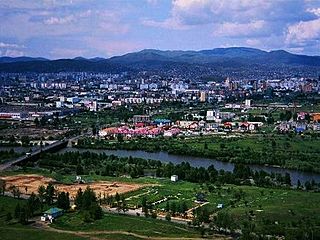
Anantnag, also called Islamabad, is the administrative headquarters of Anantnag district of Indian-administered Jammu and Kashmir in the disputed Kashmir region. It is located at a distance of 53 kilometres from the union territory's capital Srinagar. It is the third largest city in Jammu and Kashmir after Srinagar and Jammu with an urban agglomerate population of 159,838 and a municipal limit population of 109,433.

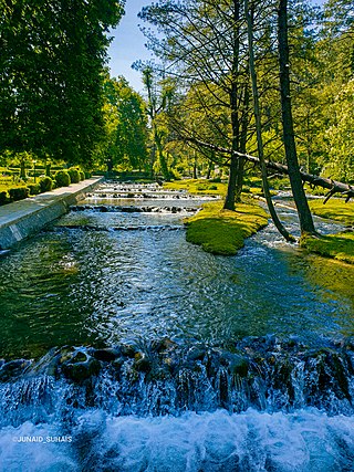
Verinag is a town named after and famous for the Verinag spring and Mughal garden, near Anantnag city in the Anantnag district of the union territory of Jammu and Kashmir, India. It is also called "gateway of Kashmir" and is a notified area committee with tehsil status and is about 26 kilometers away from Anantnag and approximately 78 kilometres south-east from Srinagar which is the summer capital of the union territory of Jammu and Kashmir. Verinag is also the first tourist spot of Kashmir Valley when travelling by road from Jammu, the winter capital of the union territory of Jammu and Kashmir towards Srinagar. There is an octagonal stone basin at Verinag Spring and an arcade surrounding it which were built by Mughal emperor Jahangir in 1620 A.D. Later, a beautiful garden next to this spring, was laid out by his son Shah Jahan. This spring is known to never dry up or overflow. Verinag Spring is also the major source of river Jhelum. Verinag Spring and Mughal Arcade surrounding it is officially recognized by Archaeological Survey of India as a Monument of National Importance.
Khrew is a town under municipal committee in Pulwama district in the Indian union territory of Jammu and Kashmir. It comes under Tehsil Pampore and District Pulwama of Union Territory of J&K. It is located at a distance of 20.3 km from Lal chowk city centre. It is famous for many things like a cement manufacturing hub where thousands of cement trucks are sent across the valley. It is also famous for the Indian army training camp where most of the new joinee soldiers get training and are sent to different places after the training is over. It is also famous for the education system having two higher secondary schools and many private schools. It is also famous for different religious places like Saint Sabir shah, Saint Syed shah Mantaqee, baba Qasim, and Jwala Mukhi Temple situated on the hilltop.
Kokernag is a sub-district town and a notified area committee in Breng Valley, Anantnag district in the Indian union territory of Jammu and Kashmir. The place is known for its botanical gardens, pristine freshwater springs, and rainbow trout farm. It is 25.3 km from Anantnag District via NH244. It is one of the most popular weekend getaways from the state capital of Srinagar.
Kulgam, known as Kolgom in Kashmiri, is a town, an administrative division and capital of the Kulgam district in the Indian union territory of Jammu and Kashmir. It is located at a distance of 67 km (42 mi) from the summer state capital of Jammu and Kashmir, Srinagar. The city is divided into 16 electoral wards that has a population of 23,584, of which 12,605 are males while 10,979 are females.

Shopian district, known as Shupyan in Kashmiri, is an administrative district of Indian-administered Jammu and Kashmir in the disputed Kashmir region. It is a hill district with its administrative headquarters in Shopian town. As it is situated on the historical road commonly known as Mughal Road, most of its area is occupied by forests. Shopian district comes under the Pir Panjal Range which makes it very cold in winter. After partition of India, it was a tehsil of Pulwama district. In March, 2007, the district status was granted by the Government of India. The economy of the district depends on agriculture, particularly apple growing.
Dialgam is a large village situated in Anantnag tehsil, in Anantnag district of Jammu and Kashmir. It is one of 150 villages in Anantnag Block along with villages like Hardu Shichan and Pal Pora.
Pethbugh is a village in Anantnag tehsil in Anantnag District in the Indian union territory of Jammu and Kashmir. It is located 7 km (4.3 mi) towards the south from the district headquarters Anantnag and 64 km (40 mi) from the summer capital of Srinagar. The Pin code of Pethbugh is 192210 and postal head office is Dialgam. The present Lambardar of Pethbugh is Mr. Fayaz Ahmad Bhat. Pethbugh is surrounded by Anantnag Tehsil towards the north, Qazigund Tehsil towards the south, Qaimoh Tehsil towards the west, and Pahloo Tehsil towards the east. Anantnag, Srinagar, Udhampur, and Rajauri are the nearby cities to Pethbugh. This place is in the border of the Anantnag and Kulgam districts. The nearest Railway Station (1.5km). Towards the west is SADURA. The Block Office of the village is BDO Office Larkipora (Shahabad). The nearest villages on boundary line are, Dialgam, Kamad, Ugjan, Schichen, Fathepora, and Sadoora.
Ratnipora (Ratanpur) is a village in the Pulwama district of the Indian union territory of Jammu and Kashmir. It is situated equally distant from three towns, Awantipora, Pulwama and Pampore. The name Ratnipora is a combination of two words, "Ratan" meaning jewel, and "Pur" meaning place.
Awantipora railway station is situated in notified area of Awantipora in the Pulwama district. It is the headquarters of Pulwama division of Northern railway zone. It is one of the four stations in Pulwama district, the others being Pampore railway station, Kakapora railway station and Panchgam railway station respectively.
Kakapora railway station is a railway station in the Northern Railway zone of Indian Railways. It is one of the four stations in Pulwama district, others being Awantipora railway station, Pampore railway station and Panzgam railway station respectively.
Lethapora, also known as Lethpora and Lalitpur, is a village in the Pampore tehsil of the Pulwama district of Jammu and Kashmir, India. It has a long history as it was named after a king Lalitaditya Muktapida, who was a powerful ruler of the Karkota dynasty of Kashmir. It was first named as Lalitpur and later changed to Lethapora. It is one of the main market for tourists and locals for Kashmiri dry fruits like walnuts, almonds etc. You can get world's finest saffron from here, which is available easily in the market. It mainly has three main markets that is Upper Market, Main Market and Down Market. Upper market is like the corporate area of the village which mainly has mixture of shops like saffron and other dry fruit shops, restaurants, hotels, tea stalls, banks, school, gym, showrooms etc. In Main Market, you will find basic shops selling fruits, vegetables, kirana and other basics and in the Down Market it mostly has saffron shops along with other shops, and restaurants

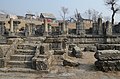
The Avantiswami Temple is an ancient ruined Hindu temple located on the banks of the Jhelum River, 28 km away from Srinagar in Awantipora, Jammu and Kashmir, India. Its ruins once consisted of two temples dedicated to Shiva and Vishnu, and were built under king Avantivarman of the Utpala dynasty in the 9th century CE. The site is maintained by the Archaeological Survey of India. Locals call the temple Pandav Lari, meaning "house of the Pandavas".

Avantivarman founded the Utpala dynasty. He ruled Kashmir from 855 to 883 CE and built the Avantiswami Temple in Awantipora, Pulwama.

Padgampora, also known as Padgampur, is a village in Awantipora tehsil in Pulwama district of Indian administered Jammu and Kashmir. It is located 14 km (8.7 mi) towards East from District headquarters Pulwama. 14 km (8.7 mi) from Tral. 25 km from State capital Srinagar.
Baragam, also known as Baragram, is a village in the Tral block of Pulwama district in the Indian union territory of Jammu and Kashmir. It is a small village located at 33°53′28.2″N75°03′26.9″E. It lies almost 35 km (22 mi) from Srinagar, and 17 km (11 mi) from district headquarters, Pulwama.
Zainapora is a village in Shopian district in the Indian union territory of Jammu and Kashmir. It is also known as land of springs because of its countless springs. Zainapora is located 19 km (12 mi) from district headquarter Shopian, 4 km (2.5 mi) from Aglar, 17 km from Pulwama, and 63 km (39 mi) from the capital Srinagar.

Midoora( مِیںڈورہ) also known as Midru, is a piedmont, agglomerated rural settlement in the Awantipora Tehsil of Pulwama district in Indian-administered Jammu and Kashmir. It is at a distance of 30 km from Srinagar and 8 km from the main town Tral and 7 km from Awantipora. In Northwest of it stands the majestic Wasturwan, a picturesque mountain forest.