Kupwara district Kopwor | |
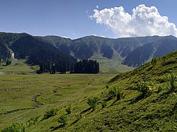
---|---|
Coordinates(Kupwara): 34°37′N74°13′E / 34.617°N 74.217°E | |
Administering country | India |
Union Territory | Jammu and Kashmir |
Division | Kashmir Division |
Established | 1979 |
Headquarters | Kupwara |
Government | |
• Lok Sabha Constituency | Baramulla |
• MP [2] | Mohammad Akbar Lone |
• Vidhan Sabha Constituencies | 6 : Karnah, Trehgam , Kupwara, Lolab, Handwara and Langate |
Area | |
• Total | 2,379 km2 (919 sq mi) |
• Urban | 47.3 km2 (18.3 sq mi) |
• Rural | 2,331.7 km2 (900.3 sq mi) |
Population | |
• Total | 870,354 |
• Density | 370/km2 (950/sq mi) |
• Urban | 104,729 |
• Rural | 765,625 |
Demographics | |
• Literacy [6] | 64.51% |
• Sex ratio [6] | 835 ♀/ 1000 ♂ |
Languages | |
• Official | Kashmiri, Urdu, Hindi, Dogri, English |
Time zone | UTC+05:30 (IST) |
Vehicle registration | JK-09 |
Major highways | NH 701 |
Website | kupwara |
Kupwara district is an administrative district of Indian-administered Jammu and Kashmir in the disputed Kashmir region. [1] It is one of the 10 districts located in the Kashmir Valley Division of Indian administered Kashmir. The Pohru River (originating in Lolab Valley and flowing from east to west) and Mawar river are two main rivers in the district. Both of them meet Jhelum river in Baramulla district. [9]
The district was carved out of the erstwhile Baramulla district in 1979 with Kupwara Town as the district headquarters. [10]
Kupwara district has a total area of 2,379 square kilometres (919 sq mi). The district is bordered by Bandipora district in the east, Baramulla district to the south and Pakistan administered Jammu and Kashmir to the north and west. The district is mostly rural/agricultural.
Most of the people depend on agriculture and horticulture. There is a good production and business of walnuts in Kupwara. [11]
Department of horticulture have developed high density walnut nursery in Kupwara [12]
Year | Pop. | ±% p.a. |
---|---|---|
1901 | 110,979 | — |
1911 | 124,744 | +1.18% |
1921 | 137,936 | +1.01% |
1931 | 153,758 | +1.09% |
1941 | 170,079 | +1.01% |
1951 | 187,076 | +0.96% |
1961 | 204,073 | +0.87% |
1971 | 257,824 | +2.37% |
1981 | 328,743 | +2.46% |
1991 | 465,948 | +3.55% |
2001 | 650,393 | +3.39% |
2011 | 870,354 | +2.96% |
source: [13] |
According to the 2011 census Kupwara district has a population of 870,354. [4] This gives it a ranking of 470th in India (out of a total of 640). The district has a population density of 368 inhabitants per square kilometre (950/sq mi). Its population growth rate over the decade 2001–2011 was 34.62%. Kupwara has a sex ratio of 843 females for every 1000 males (this varies with religion), and a literacy rate of 75.60% Scheduled Castes and Scheduled Tribes make up 0.12% and 8.08% of the population respectively.[ citation needed ]
Kupwara district: religion, gender ratio, and % urban of population, according to the 2011 Census. [5] | |||||||||
---|---|---|---|---|---|---|---|---|---|
Hindu | Muslim | Christian | Sikh | Buddhist | Jain | Other | Not stated | Total | |
Total | 37,128 | 823,286 | 1,700 | 5,600 | 66 | 39 | 13 | 2,522 | 870,354 |
4.27% | 94.59% | 0.20% | 0.64% | 0.01% | 0.00% | 0.00% | 0.29% | 100.00% | |
Male | 36,057 | 430,521 | 1,215 | 4,821 | 51 | 28 | 9 | 1,488 | 474,190 |
Female | 1,071 | 392,765 | 485 | 779 | 15 | 11 | 4 | 1,034 | 396,164 |
Gender ratio (% female) | 2.9% | 47.7% | 28.5% | 13.9% | 22.7% | 28.2% | 30.8% | 41.0% | 45.5% |
Sex ratio (no. of females per 1,000 males) | 30 | 912 | 399 | 162 | – | – | – | 695 | 835 |
Urban | 9,460 | 93,355 | 369 | 1,123 | 20 | 6 | 8 | 388 | 104,729 |
Rural | 27,668 | 729,931 | 1,331 | 4,477 | 46 | 33 | 5 | 2,134 | 765,625 |
% Urban | 25.5% | 11.3% | 21.7% | 20.1% | 30.3% | 15.4% | 61.5% | 15.4% | 12.0% |
At the time of the 2011 census, 71.11% of the population spoke Kashmiri, 14.12% Pahari, 9.21% Gujari and 2.70% Hindi as their first language. Urdu is widely-spoken as a second language. [4]
The nearest airport is Sheikh ul-Alam International Airport in Srinagar located 87 kilometres from district headquarters Kupwara. There are plans to construct an airport in Panzgam. [15]
Kupwara district is not yet connected to railways. There are plans to extend the Jammu–Baramulla line up to Kupwara in the near future. [16] The nearest railway station is Baramulla railway station located 45 kilometres from Kupwara.
Kupwara is well-connected with roads and highways. The NH 701 passes through Kupwara district alongside other intra-district roads.
The Srinagar District is an administrative district of Indian-administered Jammu and Kashmir in the disputed Kashmir region. It is one of the 20 districts of Jammu and Kashmir. Situated in the centre of the Kashmir Valley, it is the second-most populous district of the union territory after Jammu District as per the 2011 national census, and is home to the summer capital city of Srinagar. Likewise, the city of Srinagar also serves as the Srinagar District's headquarters.
Muzaffarabad is a city in Pakistani-administered Azad Kashmir in the disputed Kashmir region. It is the largest city and the capital of Azad Kashmir, which is a Pakistani-administered administrative territory.
Anantnag district is an administrative district of Indian-administered Jammu and Kashmir in the disputed Kashmir region. It is one of ten districts which make up the Kashmir Valley. The district headquarters is Anantnag city. As of 2011, it was the third most populous district of Jammu and Kashmir, after Jammu and Srinagar.
Baramulla district or Varmul is one of the 20 districts in the Indian-administered union territory of Jammu and Kashmir in the disputed Kashmir region. Baramulla town is the administrative headquarters of this district. The district covered an area of 4,588 km2 (1,771 sq mi) in 2001, but it was reduced to 4,243 km2 (1,638 sq mi) at the time of 2011 census. In 2016, the district administration said that the area was 4,190 km2 (1,620 sq mi). Muslims constitute about 98% of the population.
The Pulwama district is an administrative district of Indian-administered Jammu and Kashmir in the disputed Kashmir region. It is located to the south of Srinagar. Its district headquarters are situated in the city of Pulwama. It is located in the central part of the Kashmir Valley.
Bagh District is a district of Pakistan-administered Azad Kashmir in the disputed Kashmir region. It is one of the ten districts of Azad Jammu and Kashmir. Previously part of Poonch District, Bagh was established as a separate district in 1988.
Baramulla, also known as Varmul in Kashmiri, is a city and municipality of the Baramulla district of the Indian-administered Jammu and Kashmir in the disputed Kashmir region. It is also the administrative headquarters of the Baramulla district, located on the banks of the River Jhelum downstream from Srinagar, the summer capital of Jammu and Kashmir. The town is known as gateway of Kashmir, serving as the major distribution centre for goods arriving in Kashmir valley through the Jhelum valley cart road.
Jammudistrict is an administrative district of the Jammu division of Indian-administered Jammu and Kashmir in the disputed Kashmir region. It is the most populous district in the Jammu division.
Pulwama is a city and notified area council in the Pulwama district of Indian-administered Jammu and Kashmir in the disputed Kashmir region. It is located approximately 25 kilometres (16 mi) south of the summer capital of the state, Srinagar.
Anantnag, also called Islamabad, is the administrative headquarters of Anantnag district of Indian-administered Jammu and Kashmir in the disputed Kashmir region. It is located at a distance of 53 kilometres from the union territory's capital Srinagar. It is the third largest city in Jammu and Kashmir after Srinagar and Jammu with an urban agglomerate population of 159,838 and a municipal limit population of 109,433.
Budgam district is an administrative district of Indian-administered Jammu and Kashmir in the disputed Kashmir region. Created in 1979 with its headquarters at the town of Budgam, it is the district with the largest population of Shia Muslims in the Kashmir valley.
Reasi district is an administrative district in the Jammu division of Indian-administered Jammu and Kashmir in the disputed Kashmir region. The Reasi district is bordered by Udhampur district and Ramban district in the east, Jammu district in the south, Rajouri district in the west and by Kulgam district on the north. The Reasi and Rajouri tehsils formed a joint district called the "Reasi district" at the time of the princely state's accession to India in 1947. As part of the reorganisation, the two tehsils were separated and Reasi was merged with the Udhampur district. It again became a separate district in 2006.
Neelum is a district of Pakistan-administered Azad Kashmir in the disputed Kashmir region. It is the northernmost of 10 districts located within the Pakistani-administered territory of Azad Kashmir. Taking up the larger part of the Neelum Valley, the district had a population of around 191,000 people. It was among the worst-hit areas of Pakistan during the 2005 Kashmir earthquake.
Bandipore district is an administrative district of Indian-administered Jammu and Kashmir in the disputed Kashmir region. It is one of the 20 districts in the Jammu and Kashmir. Bandipore town is the administrative headquarters of the district. Bandipore is located in the foothills of the snow-clad peaks of Harmukh overlooking the shores of Wular Lake and has produced hundreds of scholars and intellectuals. The district is known for its tourist places such as Wular Vintage Park, Athwatoo and Gurez valley. Before 1947, this town was a big trade and literary centre of Kashmir. This district was carved out from the erstwhile Baramulla district in 2007. The district is bounded by Kupwara district from the north, Baramulla district from west and Kargil district in Ladakh and Ganderbal district from the east. This district occupies an area of 398 km2. The district has a population of 392,232 as per 2011 census.
The Haveli District is a district of Pakistan-administered Azad Kashmir in the disputed Kashmir region. It is one of the 10 districts of the Pakistan-administered territory of Azad Kashmir. It was previously a tehsil of the Bagh District but was elevated to the district status on 1 July 2009.
Hattian Bala District is a district of Pakistan-administered Azad Kashmir in the disputed Kashmir region. The town of Hattian Bala is where the district headquarters are located. The Hattian Bala District was a part of the Muzaffarabad District until 2009 when it was made a separate district.
The Kashmir division is a revenue and administrative division of the Indian-administered Jammu and Kashmir in the disputed Kashmir region. It comprises the Kashmir Valley, bordering the Jammu Division to the south and Ladakh to the east. The Line of Control forms its boundary with the Pakistani-administered territories of Gilgit−Baltistan and Azad Jammu and Kashmir to the north and west and west, respectively.
Gilgit Division is an administrative division of Pakistan-administered Gilgit-Baltistan in the disputed Kashmir region. Gilgit is the divisional headquarters of Gilgit Division. Since divisions were restored as an administrative structure in 2008, the division currently consists of six districts:
Baltistan Division is a first-order administrative division of Pakistan-administered Gilgit-Baltistan in the disputed Kashmir region. It overlaps with the historical Baltistan region.
Sheeri is a village located in Baramulla district of Jammu and Kashmir, India. The village has two adjoining areas namely "Sheeri Bala" and "Sheeri Payeen". It is located 10 km towards the west of the district headquarters Baramulla and 52 km from the state capital Srinagar. Sheeri is surrounded by Singhpora Tehsil to the east, Rohama Tehsil to the north, Kralpora Tehsil to the south and Boniyar Tehsil to the west.