Kishtwar | |
|---|---|
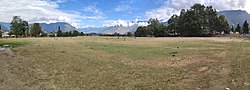 View of Chowgan Ground in Kishtwar town, Jammu and Kashmir, India | |
 Kishtwar Location in Jammu and Kashmir, India  Kishtwar Kishtwar (India) | |
| Coordinates: 33°19′N75°46′E / 33.32°N 75.77°E | |
| Country | |
| Union Territory | Jammu & Kashmir |
| Division | Jammu |
| District | Kishtwar |
| Government | |
| • Type | Municipal Council |
| • Body | Kishtwar Municipal Council |
| Area | |
• Total | 22.5 km2 (8.7 sq mi) |
| Elevation | 1,638 m (5,374 ft) |
| Population (2011) | |
• Total | 14,865 |
| • Density | 660/km2 (1,700/sq mi) |
| Languages | |
| • Official | Kashmiri, Urdu, English [1] [2] |
| • Spoken | Kishtwari, Kashmiri, Hindi-Urdu |
| Time zone | UTC+5:30 (IST) |
| PIN | 182204 |
| Vehicle registration | JK17 |
| Website | www |
Kishtwar is a town, municipality and administrative headquarter of the Kishtwar district in the Jammu division of the Indian union territory of Jammu and Kashmir. [3] Kishtwar district lies in the Chenab Valley and was carved out of the Doda district in 2007. [4]
Contents
The town of Kishtwar is situated at a distance of 209.5 km (130.2 mi) from the summer capital of Srinagar, and 211.5 km (131.4 mi) from the winter capital of Jammu. A large ground locally called as Chowgan ground is located in the heart of the town. [5] The old name of Kishtwar was "Kashtvatha" as mentioned in Rajtarangni of Kalhana Pandita written in 1148 CE.
In August 2013, the town was the location of violent religious riots, which claimed three lives and injured 80 more. [6] [7] The conflict was between the Muslim and Hindu communities that occurred in the aftermath of the Eid festival on 9th August.
