Ganderbal

Last updated

Ganderbal
Town
Ganderbal from rangil mountain.jpg
View of Ganderbal town in Jammu and Kashmir, India
India Jammu and Kashmir Union Territory location map.svg
Red pog.svg
Ganderbal
Location in Jammu and Kashmir, India
India location map.svg
Red pog.svg
Ganderbal
Ganderbal (India)
Coordinates: 34°14′N74°47′E / 34.23°N 74.78°E / 34.23; 74.78
CountryFlag of India.svg  India
Union Territory Jammu and Kashmir
District Ganderbal
Named for Beauty
Elevation
1,619 m (5,312 ft)
Population
 (2011)
  Total28,233
Demonym(s) Ganderbali, Ganderbalia, Ganderbalan
Languages
  Official Kashmiri, Urdu, English [1] [2]
  Spoken Pahari, Gujari, Shina, Balti, Pashto
Time zone UTC+5:30 (IST)
Vehicle registration JK16
Website ganderbal.nic.in
Ganderbal (constituency of the Jammu and Kashmir Legislative Assembly) Ganderbal 3.jpg
Ganderbal (constituency of the Jammu and Kashmir Legislative Assembly)

Ganderbal is a town and a municipality committee in Ganderbal District in the Indian union territory of Jammu and Kashmir. It is the headquarters of Ganderbal district. It is in Central Kashmir; it has an average elevation of 1,619 metres (5,312 feet). It is bordered by district Srinagar District in the south, Bandipora District to the north, Kargil (Indian union territory of Ladakh) in the northeast, Anantnag District to the southeast, and Baramulla District in the southwest. The current District Magistrate of Ganderbal is Mr. Shyambir Singh (IAS). Ganderbal is renowned for its beauty, boasting numerous picturesque places and captivating landscapes. Sonamarg is the most famous place in Ganderbal; Shri Amarnath Ji Yatra is also traversed through Ganderbal district.

Contents

Geography

Ganderbal is located at 34°14′N74°47′E / 34.23°N 74.78°E / 34.23; 74.78 . [3] It has an average elevation of 1,619 metres (5,312 feet) above sea level. It is bordered by the Srinagar district in the south, Bandipore to the north, Kargil in the northeast, Anantnag to the southeast and Baramulla to the southwest. It is divided into six Tehsils viz, Ganderbal, Kangan, Lar, Tulmulla, Gund and Wakura.

Power project

The Sind River, a major tributary to the Jehlum River flows through this district. The water of the river is mainly used for irrigation, and generation of hydroelectricity. There are three hydroelectric power stations, Lower Sindh Hydroelectric Power Project Ganderbal, Upper Sindh Hydroelectric Power Project 1st Kangan and Upper Sindh Hydroelectric Power Project 2nd Sumbal generating electricity on the Sind River. Besides, the water of the river is used for drinking by Srinagar city through Rangil Water Treatment Plant. [4]

Tourism

Water rafting tournaments are being organised at the tourist destination of Sonamarg every year, to boost the tourism industry of Kashmir valley. Besides Manasbal lake, Gangabal Lake [5] at the foot of Mount Haramukh is one of the destinations of foreign tourists visiting the valley. Vaishnosar Lake and Gadsar Lake are situated north of Sonamarg.

Development

Despite the fact that in the past Ganderbal has remained CM's [6] constituency, [7] it has remained quite behind in development as compared to other districts. Ganderbal constituency was represented by Sheikh Ishfaq Jabbar who defeated Qazi Mohammad Afzal by a little margin of 461 votes in recently held state assembly elections 2014. The Central University of Kashmir [8] is being constructed in district Ganderbal. There Faculties, the Faculty of Forestry, Fisheries and Veterinary Sciences and Animal Husbandry of Sher-e-Kashmir University of Agricultural Sciences and Technology of Kashmir are also located within the jurisdiction of Ganderbal, serving to boost the economy and education of the district. Besides, there is a stadium which holds a record of playing a day-night matches Physical Education College, the only one in the state, is situated at Gadoora village, some 3.5  km away from district headquarters.

Demographics

Religion in Ganderbal Town (2011) [9]

   Islam (98.21%)
   Hinduism (1.37%)
   Sikhism (0.13%)
  Christianity (0.15%)
   Buddhism (0.01%)
  Not Stated (0.13%)

As of 2011 India census, [10] Ganderbal had a population of 297446. [11] Males constitute 53.36% of the population and females 46.64%. Ganderbal has an average literacy rate of 58.04%, lower than the national average of 74.04%: male literacy is 68.85%, and female literacy is 45.71%. In Ganderbal, 17.01% of the population is under 6 years of age. [12]

Politics

The Municipal Committee Ganderbal is an Urban Local Body with 17 elected members. Its last elections took place on 16 October 2018. [13]

Keys:   BJP (2)   INC (2)  Independent (13)

#NameMunicipal WardReservation StatusParty
1Samia AhadBeehama NagriporaWomen OpenIndependent
2Abdul Rashid RatherBeehama Wahid SahibOpenIndependent
3Jeelani Ahmed MirGanderbal AOpen BJP
4HaleemaGanderbal BWomen OpenIndependent
5Showkat Ahmad MirArampora AOpenIndependent
6Altaf Ahmad LoneArampora BOpenIndependent
7Mehak ShahDuderhama GousiaWomen Open INC
8Hilal Ahmad TantrayDuderhamaOpenIndependent
9Nazir Ahmad GanaieFathipora AOpenIndependent
10Rashida BanoFatehpora BWomen OpenIndependent
11Ghulam Hassan DarGangerhama AOpenIndependent
12Bashir Ahmad KoulGangerhama BOpenIndependent
13NablaWaniporaWomen OpenIndependent
14Sajjad AhmadBamlooraOpen INC
15Lateef AhmadSaloora AOpen BJP
16SaraSaloora BWomen OpenIndependent
17Abdul MajidSaloora COpenIndependent

Education

The following renowned educational institutes are located within Ganderbal [14] :

1. Central University of Kashmir Tulmulla.

2. Facilities of Fisheries (Rangil), Forestry (Benhama), Veterinary Sciences and Animal Husbandry (Shuhama) of Sher-e-Kashmir University of Agricultural Sciences and Technology of Kashmir.

3. Government Degree College, Ganderbal.

4. Government Degree College, Kangan.

5. Government Polytechnic College, Hathbura.

6. Government College of Physical Education, Gadoora.

7. Government College of Engineering and Technology, Safapora.

8. Qamariya College of Education and Training, Badampora.

9. Sainik School, Manasbal.

10. Jawahar Navodaya Vidyalaya, Hathbura.

11. ITI, Ganderbal.

12. ITI, Kangan.

13. Government Unani Medical College/Hospital, Nawabagh.

These institutions play a significant role in shaping the educational landscape of Ganderbal and contribute to the academic development of the region.

Transport

Road

Ganderbal is well-connected by road to other places in Jammu and Kashmir and India by the NH 1.

Rail

Ganderbal is not connected with railways. The nearest railway station is Srinagar railway station located at a distance of 31 kilometres.

Air

The nearest airport is Srinagar International Airport located at a distance of 30 kilometres.

See also

Related Research Articles

<span class="mw-page-title-main">Jhelum River</span> River in India and Pakistan

The Jhelum River is a river in the northern Indian subcontinent. It originates at Verinag and flows through the Indian-administered territory of Jammu and Kashmir, into Pakistani-administered Azad Kashmir, then the Pakistani province of Punjab. It is the westernmost of the five rivers of the Punjab region, and flows through the Kashmir Valley. It is a tributary of the Chenab River and has a total length of about 725 kilometres (450 mi).

<span class="mw-page-title-main">Anantnag district</span> District of Jammu and Kashmir, India

Anantnag district is an administrative district of Indian-administered Jammu and Kashmir in the disputed Kashmir region. It is one of ten districts which make up the Kashmir Valley. The district headquarters is Anantnag city. As of 2011, it was the third most populous district of Jammu and Kashmir, after Jammu and Srinagar.

<span class="mw-page-title-main">Baramulla district</span> District in Jammu and kashmir, India

Baramulla district or Varmul is one of the 20 districts in the Indian-administered union territory of Jammu and Kashmir in the disputed Kashmir region. Baramulla town is the administrative headquarters of this district. The district covered an area of 4,588 km2 (1,771 sq mi) in 2001, but it was reduced to 4,243 km2 (1,638 sq mi) at the time of 2011 census. In 2016, the district administration said that the area was 4,190 km2 (1,620 sq mi). Muslims constitute about 98% of the population.
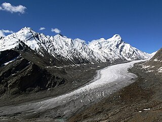
<span class="mw-page-title-main">Kokernag</span> Sub-District and Town in Anantnag, Jammu and Kashmir

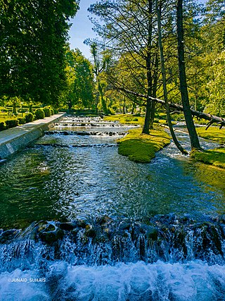
Kokernag is a sub-district town and a notified area committee in Breng Valley, Anantnag district in the Indian union territory of Jammu and Kashmir. The place is known for the botanical gardens, pristine freshwater springs, and rainbow trout farm. It is 25.3 km from Anantnag via NH244. It is one of the most popular weekend getaways from the state capital of Srinagar.

<span class="mw-page-title-main">Sher-e-Kashmir University of Agricultural Sciences and Technology of Kashmir</span> Agricultural university in Srinagar, India

Sher-e-Kashmir University of Agricultural Sciences and Technology of Kashmir is an agricultural university located in Shalimar, Srinagar, Jammu and Kashmir, India. With its main campus and Faculty of Horticulture in Shalimar, Srinagar, the university has multiple campuses, colleges, research and extension centers across the Kashmir Valley and Ladakh Union Territory. The Faculty of Agriculture (FoA) is located in Wadura, Sopore

Sumbal is a town and a notified area committee in the Bandipora district of the Indian union territory of Jammu and Kashmir. Sumbal is 19 kilometres away from Srinagar. The surrounding parts of sumbal consist of many villages like Nowgam, Zalpora, shadipora, Shahtulpora, Shilwat, Shiganpora, Inderkote. This area has one of the significant Shia population in Kashmir. The place is rich in literature and agriculture. Sumbal is situated on the bank of the river Jhelum and is adjacent to the Manasbal lake. There are also many notable figures from this area including Kashmir's first Muslim lady pilot Iram Habibi and many other personalities particularly poets. The zalpora village of Sumbal joins two districts, Bandipora and Baramulla which serves as another route to connect the districts Kupwara and Baramulla to Srinagar. Sumbal city is divided into 13 wards, for which elections are held every 5 years.

<span class="mw-page-title-main">Sonamarg</span> Hill station in Jammu and Kashmir, India

Sonamarg or Sonmarg, known as Sonamarag in Kashmiri, is a hill station located in the Ganderbal District of Jammu and Kashmir, India. It is located about 62 kilometers from Ganderbal Town and 80 kilometres (50 mi) northeast of the capital city, Srinagar.

<span class="mw-page-title-main">Tourism in Jammu and Kashmir</span> Tourist places in Jammu and Kashmir

Jammu and Kashmir is home to several valleys such as the Kashmir Valley, Chenab Valley, Sindh Valley and Lidder Valley. Some major tourist attractions in Jammu and Kashmir are Srinagar, with its renowned Dal Lake and Mughal Gardens, Gulmarg, Pahalgam, Bhaderwah, Patnitop and Jammu. Every year, thousands of Hindu pilgrims visit holy shrines of Vaishno Devi and Amarnath which has had a significant impact on the state's economy.

<span class="mw-page-title-main">Ganderbal district</span> District in Jammu and Kashmir, India

The Ganderbal district, or more formally District Ganderbal, is an administrative district of Indian-administered Jammu and Kashmir in the disputed Kashmir region. Ganderbal town is the administrative headquarters of the district. It was formed in 2007 and has 6 subdistricts (tehsils): Kangan, Ganderbal, Tullamulla, Wakura, Lar, and Gund.

Kangan is a town located near Ganderbal, in the Ganderbal district of Jammu and Kashmir, India. It is one of the tehsils in District Ganderbal. It is situated across the Nallah Sindh and spread over a 50-km-long gorge valley, with population of 120,934 and literacy rate of 52.8% and sex ratio 868 per thousand males. Widely regarded for its beauty, it is surrounded by various picnic spots like Sonamarg and Naranag.
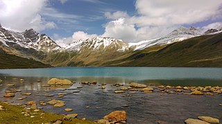
<span class="mw-page-title-main">Sind River</span> River in Indian-administered Jammu and Kashmir, tributary of the Jhelum River

The Sind River or the Sindh River is a river in the Ganderbal district of the union territory of Jammu and Kashmir, India. It is a major tributary of the Jhelum River and is 108 km (67 mi) long.

Lar is a town and council district in the Ganderbal district of central Kashmir, in Jammu and Kashmir, India. It is a relatively newly established tehsil, carved out of the Ganderbal tehsil. It is situated 25 km from the heart of the summer capital, Srinagar, on National Highway between the foothills of the Himalayan mountains in the north and the picturesque Zabarwan Hills in the south. The Sind River, a major tributary to the Jehlum River flows through Lar. The famous Manasbal Lake lies a few kilometres away from the town centre.

<span class="mw-page-title-main">Sind Valley</span> Region in the Jammu and Kashmir, India

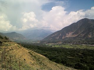
The Sind Valley is a Himalayan sub-valley of the Kashmir Valley in the Indian union territory of Jammu and Kashmir. The entrance of the Sind Valley lies 33 kilometres (21 mi) northeast of Srinagar the capital of Jammu and Kashmir. It is a 65 kilometres (40 mi) long gorge valley with an average width of 1 kilometre (0.62 mi).

Safapora, also pronounced as Safapur is a model village in Ganderbal District, Jammu and Kashmir, India. It is 13 km (8.1 mi) away from district headquarter Ganderbal and 30 km (19 mi) away from the summer capital Srinagar via Sumbal as well as via Ganderbal. Manasbal Lake, the deepest lake in India, is located in Safapora and is surrounded by two Mughal gardens built by Nur Jahan, Qazi Bagh and Jarokha Bagh. There is a Wullar Manasbal development authority run by state government in Safapora. The area serves as the education hub for the adjoining areas of Chanderger, Hakbara, Asham, Chewa, and Kondabal. In addition, some students from Bandipora District also prefer to receive their education in Safapora. The Safapora area has also good literacy rate. Safapora is also a tourist destination and most tourists visit the Manasbal Lake, the surrounding two parks, Fisheries. Jammu and Kashmir Government College of Engineering and Technology is also located in Safapora.

Wakura is a village located in the Ganderbal district of Jammu and Kashmir, India. In 2013 it was given tehsil status, with the tehsil headquarters located in Lar, 13 km away.

<span class="mw-page-title-main">Nawabagh Ganderbal</span> Place in Jammu and Kashmir, India

Nawabagh is the notified area and village in Ganderbal district in the Indian union territory of Jammu and Kashmir. The place is famous for the production of apples, cherries, peaches, apricots, walnuts, and pears, which are exported all over India. The varieties of apples that grow in the area include the American apple, Delicious, Golden, Kullu Delicious, Amur, Red Gold, Razak Wari and Maharaji. The postal code of the area is 193501.

References

  1. "The Jammu and Kashmir Official Languages Act, 2020" (PDF). The Gazette of India. 27 September 2020. Retrieved 27 September 2020.
  2. "Parliament passes JK Official Languages Bill, 2020". Rising Kashmir. 23 September 2020. Retrieved 23 September 2020.
  3. Falling Rain Genomics, Inc – Ganderbal. Fallingrain.com. Retrieved on 2011-12-14.
  4. Rangil Water Treatment Plant finds hard to feed tail-end areas Lastupdate:- Fri, 4 Sep 2009 18:30:00 GMT. Greaterkashmir.com (4 September 2009). Retrieved on 2011-12-14.
  5. Gangabal Lake in India. India9.com (7 June 2005). Retrieved on 2011-12-14.
  6. Chief Minister of Jammu and Kashmir
  7. Electoral constituency
  8. Central University of Kashmir, Ganderbal | CareerPages Archived 23 August 2011 at the Wayback Machine . Careerpages.in. Retrieved on 2011-12-14.
  9. "Ganderbal Town Population". Census India. Retrieved 11 July 2021.
  10. "Census of India 2001: Data from the 2001 Census, including cities, villages and towns (Provisional)". Census Commission of India. Archived from the original on 16 June 2004. Retrieved 1 November 2008.
  11. census of India official website, www.census2011.co.in
  12. this is census of India 2011, www.census2011.co.in
  13. http://ceojammukashmir.nic.in/pdf/municipal%20Election/Result_Notifi_Corp.pdf [ bare URL PDF ]
  14. https://ganderbal.nic.in/public-utility-category/colleges/