The Dras River, also spelt Drass River, is a river in the Kargil district in the Indian union territory of Ladakh. It originates below the Zoji La pas in the Great Himalayan range and flows northeast towards Kargil, where it joins the Suru River. The Shingo River, which flows in a parallel direction in Pakistan-administered Baltistan, also joins the Drass River. The combined river is alternatively called Suru, Drass and Shingo by various local groups.
The Drang-Drung Glacier is a mountain glacier near the Pensi La pass on the Kargil-Zanskar Road in the Kargil district of Ladakh in India.

Ganderbal is a town and a municipality committee in Ganderbal district in the Indian union territory of Jammu and Kashmir. It is the headquarters of Ganderbal district.It is in Central Kashmir, it has an average elevation of 1,619 metres. It is bordered by district Srinagar in the south, Bandipore to the north, Kargil in the northeast, Anantnag to the south-east and Baramulla in the south-west.The current District Magistrate of Ganderbal is Mr. Shyambir Singh.District Ganderbal is known for its beauty,there are many beautiful places in Ganderbal.Sonmarg is the most famous place in Ganderbal, Shri Amarnath Ji Yatra is also done in Ganderbal.

Sonamarg or Sonmarg, known as Sonamarag in Kashmiri, is a hill station located in the Ganderbal District of Jammu and Kashmir, India. It is located about 62 kilometers from Ganderbal Town and 80 kilometres (50 mi) northeast of the capital city, Srinagar.

The valleys of Jammu and Kashmir include the Kashmir Valley, Chenab Valley, Sindh Valley, and Lidder Valley. Srinagar, with its renowned Dal Lake and Mughal Gardens, Gulmarg, Pahalgam, Bhaderwah, Patnitop, and Jammu are all popular tourist destinations in Jammu and Kashmir. Thousands of Hindu pilgrims visit the sacred temples of Vaishno Devi and Amarnath each year, which has a substantial impact on the state's economy.

The Ganderbal (گاندربل) district, or more formally District Ganderdal, is an administrative district of Indian-administered Jammu and Kashmir in the disputed Kashmir region. Ganderbal town is administrative headquarters of district. It was formed in 2007 and has 6 subdistricts (tehsils): Kangan, Ganderbal, Tullamulla, Wakura, Lar, and Gund.
Baltal is a camping ground for pilgrims, 75 km from Ganderbal town in Ganderbal district of Jammu and Kashmir, India and 93 km from capital city Srinagar and 15 km north of Sonamarg on the Sind River at the base of Zojila pass. This little valley is only a day's journey away from Srinagar and provides a shorter high-altitude alternate route to the sacred cave of Amarnath.
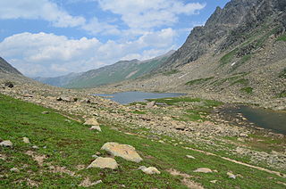
The Gangabal Lake, also called Haramukh Ganga, is an alpine high-altitude oligotrophic lake situated at the foot of Mount Haramukh in the Ganderbal district of Jammu and Kashmir, India. The lake has a maximum length of 2.5 kilometres (1.6 mi) and maximum width of 1 kilometre (0.62 mi). It is fed by precipitation, glaciers and springs and is home to many species of fish, including the brown trout. Water from the lake outflows into the nearby Nundkol Lake and then into the Sind River via Wangath Nallah. This lake is considered sacred in Hinduism as one of the abodes of Shiva, and Kashmiri Hindus perform an annual pilgrimage to the lake called Harmukh-Gangabal Yatra.

The Sind River or the Sindh River is a river in the Ganderbal district of the union territory of Jammu and Kashmir, India. It is a major tributary of the Jhelum River and is 108 kilometres long.

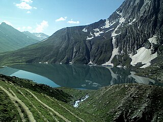
The Gadsar Lake, also called Yemsar, is an alpine high altitude oligotrophic lake in the Ganderbal district of Kashmir Division in Jammu and Kashmir, India. It has an elevation of 3,600 metres (11,800 ft), a maximum length of 0.85 km and maximum width of 0.76 km.
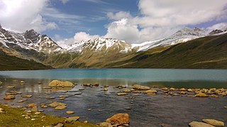
The Vishansar Lake is an alpine high-elevation oligotrophic lake, situated near Sonamarg in the Ganderbal district of Jammu and Kashmir, India, at an elevation of 3,710 metres (12,170 ft). It has a maximum length of 1 km, and maximum width of 0.6 km.

Kolahoi Peak is a mountain with a peak elevation of 17,799 ft located in Anantnag district, Jammu and Kashmir, India. The mountain is the highest mountain in Kashmir Division. Kolahoi Peak is easily accessible through Aru valley and lies in the vicinity of Sonamarg in Ganderbal district. Kolahoi Peak is part of the Great Himalayan range, and is located 21 km north of Aru near Pahalgam. To its north flows the Sind River, while the Lidder River originates from the glacier located on the mountain and flows south.
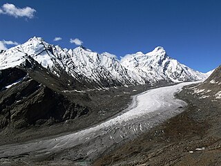
The Machoi Glacier is a 9 kilometer long glacier in the Himalayan Range in Jammu and Kashmir and Ladakh, India.
Sirbal Peak is a mountain with a peak elevation of 5,235 metres (17,175 ft), in the Ganderbal district of the Indian union territory of Jammu and Kashmir, in the vicinity of Sonamarg. Sirbal Peak is part of the Himalaya Range, and is located between Sonamarg and Baltal. It lies 102 km northeast from Srinagar, 5 km from Sonamarg in the east. Sirbal Peak lies 6 km west of Zojila. It rises from a glacier 5 km ahead from Sonamarg on left side of NH 1D. The melt waters from the glacier add to the flow of Nallah Sindh.
Amarnath Peak is a mountain with a peak elevation of 5,186 metres (17,014 ft), in the Ganderbal district of the Indian union territory of Jammu and Kashmir, in the vicinity of Sonamarg. Amarnath Peak is part of the Himalayas, and is located south of Zojila and west of Machoi Glacier. It lies 117 km northeast from Srinagar, 13 km from Baltal in the southeast. It lies 6 km south of Zojila. The melt waters form a major tributary of the Sind River at Baltal.
Lar is a town and council district in the Ganderbal district of central Kashmir, in Jammu and Kashmir, India. It is a relatively newly established tehsil, carved out of the Ganderbal tehsil. It is situated 25 km from the heart of the summer capital, Srinagar, on National Highway between the foothills of the Himalayan mountains in the north and the picturesque Zabarwan Hills in the south. The Sind River, a major tributary to the Jehlum River flows through Lar. The famous Manasbal Lake lies a few kilometres away from the town centre.

Naranag or is a tourist village and ancient Hindu pilgrimage site, near Ganderbal town in the Ganderbal district of the Kashmir Valley in Jammu and Kashmir, India. Well known for its ancient but pillaged temple ruins complex, it is located around 8 km from Kangan, 6 km upstream from the Sind River. Noted for its scenic meadows, lakes and mountains, it is a base camp for trekking to the Mount Haramukh 16,870 ft and Gangabal Lake. The village lies at the left bank of the Wangath river, which is a tributary of the Sind River. Tourism hut at Naranag for any information and assistance tourism officials are available and hut is also provide for accommodation.
The Satsar Lake or Sat Sar consists of seven small alpine lakes situated in Ganderbal district of the Kashmir Valley in Jammu and Kashmir, India.
Wangath Temple complex is a group of Hindu temple monuments in Wangath, close to Naranag, in the Ganderbal district of the Kashmir Valley of Jammu and Kashmir, India. Wangath is a village located around 48 miles (77 km) northeast of Srinagar. The current structure was built by Lalitaditya Muktapida of the Karkota dynasty in the 8th century CE.

The Z-MorhTunnel is an under-construction 6.5 km long 2-lane road tunnel between Gagangair and Sonamarg in Ganderbal district of Union Territory of Jammu and Kashmir in India. It is named after the Z-shaped stretch of road that the tunnel will replace. The road is avalanche-prone and gets blocked for several months. The Z-Morh tunnel will provide all-weather connectivity to the Sonamarg tourist town. It will take only 15 minutes to travel the 6.5 km long tunnel compared to hours over the zig-zag road up and down the hills.