
Srinagar is a city in Indian-administered Jammu and Kashmir in the disputed Kashmir region. It is the largest city and summer capital of Jammu and Kashmir, which is an Indian-administered union territory. It lies in the Kashmir Valley along the banks of the Jhelum River, and the shores of Dal Lake and Anchar Lakes, between the Hari Parbat and Shankaracharya hills. The city is known for its natural environment, various gardens, waterfronts and houseboats. It is also known for traditional Kashmiri handicrafts like the Kashmir shawl, papier-mâché, wood carving, carpet weaving, and jewel making, as well as for dried fruits. It is the second-largest metropolitan area in the Himalayas.

The Jhelum River is a river in the northern Indian subcontinent. It originates at Verinag and flows through the Indian-administered territory of Jammu and Kashmir, into Pakistan-administered Azad Kashmir, then the Pakistani province of Punjab. It is the westernmost of the five rivers of the Punjab region, and flows through the Kashmir Valley. It is a tributary of the Chenab River and has a total length of about 725 kilometres (450 mi).

Rājataraṅgiṇī is a metrical legendary and historical chronicle of the north-western part of Indian sub-continent, particularly the kings of Kashmir. It was written in Sanskrit by Kashmiri historian Kalhana in the 12th century CE.

The Pir Panjal Range is a range of mountains in the Lower Himalayan region located in the Western Himalayas of northern Indian subcontinent. It runs southeast to northwest between the Beas and Neelam/Kishanganga rivers, in the Indian state of Himachal Pradesh and Indian-administered union territory of Jammu and Kashmir, with its northwestern end extending into territory administered by Pakistan. The Himalayas show a gradual elevation towards the Dhauladhar and Pir Panjal ranges. Pir Panjal is the largest and westernmost range of the Lesser Himalayas. Near the bank of the Sutlej River, it dissociates itself from the main Himalayan range and forms a divide between the Beas and Ravi rivers on one side and the Chenab on the other. Further west, the Pir Panjal range forms the southwestern boundary of the Kashmir Valley, separating it from the hills of Jammu region, forming a divide between the Jhelum and Chenab rivers.

Achabal, known as Achival in Kashmiri, is a town in Anantnag district, in the union territory of Jammu and Kashmir, India.

Verinag is a town named after and famous for the Verinag spring and Mughal garden, near Anantnag city in the Anantnag district of the union territory of Jammu and Kashmir, India. It is also called "gateway of Kashmir" and is a notified area committee with tehsil status and is about 26 kilometers away from Anantnag and approximately 78 kilometres south-east from Srinagar which is the summer capital of the union territory of Jammu and Kashmir. Verinag is also the first tourist spot of Kashmir Valley when travelling by road from Jammu, the winter capital of the union territory of Jammu and Kashmir towards Srinagar. There is an octagonal stone basin at Verinag Spring and an arcade surrounding it which were built by Mughal emperor Jahangir in 1620 A.D. Later, a beautiful garden next to this spring, was laid out by his son Shah Jahan. This spring is known to never dry up or overflow. Verinag Spring is also the major source of river Jhelum. Verinag Spring and Mughal Arcade surrounding it is officially recognized by Archaeological Survey of India as a Monument of National Importance.

Shankaracharya Temple or Jyeshteshwara Temple is a Hindu temple situated on top of the Zabarwan Range in Srinagar in the union territory of Jammu and Kashmir. It is dedicated to Shiva. The temple is at a height of 1,000 feet (300 m) above the valley floor and overlooks the city of Srinagar. The temple is accessible via a road that emerges off Boulevard road near Gagribal.
The Bomba, also spelled Bambas, are a Rajput tribe found in the Pakistani-controlled territory of Azad Jammu and Kashmir and the Indian-controlled Union territory of Jammu and Kashmir. In Azad Kashmir, they are primarily found in Muzaffarabad and Neelum districts, with a large number concentrated in and around the town of Ghori. Outside of Azad Kashmir, they are also found in the Boi and Kaghan valleys of Mansehra District, and the city of Abbottabad, all located in Khyber Pakhtunkhwa. In Jammu and Kashmir, they are found in the Poonch and Rajouri districts of Jammu division.

The Sind River or the Sindh River is a river in the Ganderbal district of the union territory of Jammu and Kashmir, India. It is a major tributary of the Jhelum River and is 108 km long.

The Sher Garhi Palace is a historic royal residence in Srinagar, Jammu and Kashmir, India. Situated south of the Old City of Srinagar, along the banks of the Jhelum River, its name,"Sher Garhi," translates to "Fort of the Lion,"highlighting its role as a prominent seat of power. Initially constructed in 1772 by Afghan governor Jawansher Khan, it served as the residence of Afghan rulers before becoming home to the Dogra Maharajas of Jammu and Kashmir.

Parihaspora or Parihaspur or Paraspore or Paraspur was a small town 22 kilometres (14 mi) northwest of Srinagar in the Kashmir Valley. It was built on a plateau above the Jhelum River. It was built by Lalitaditya Muktapida and served as the capital of Kashmir during his reign.

Khanqah-e-Moula, also known as Shah-e-Hamadan Masjid and Khanqah, is a mosque located in the Old City of Srinagar in Jammu and Kashmir, India. Situated on the right bank of the river Jhelum between the Fateh Kadal and Zaina Kadal bridges, it was built in 1395 CE, commissioned by Sultan Sikendar in memory of Mir Sayyid Ali Hamadani. It is held to be the first Khanqah—mosques associated with specific saints—in the Kashmir valley. It is one of the best examples of Kashmiri wooden architecture, and is decorated with papier mache.
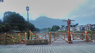
The Zero Bridge is a wooden arch bridge located in the city of Srinagar in the Indian union territory of Jammu and Kashmir. It crosses the Jhelum river in a roughly North-South direction connecting Sonwar in the north to Rajbagh in the South. Originally constructed in the late 1950s under the then chief minister Bakshi Ghulam Mohammad, the bridge was closed for vehicular traffic in the late 1980s owing to the weakening of its wooden structure.
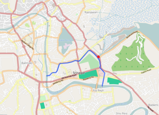
Tsoont Kol is a navigational canal running through the Srinagar city of the Indian state of Jammu and Kashmir, that also helps to regulate the water level in the Dal lake. It branches out from the Jhelum just near the northern end of the Zero Bridge and rejoins it in the Maisuma locality of the old city, a few metres downstream of the Budshah Bridge. It has a lock gate known as Dal Gate to regulate the water level in the Dal lake which is located at a slightly higher elevation. The canal also has an island just after the Dal Gate, known as Chinar Bagh.
Safa Kadal, also spelled Safakadal is an old neighborhood in the city of Srinagar in Jammu and Kashmir, India. The word kadal means bridge in Kashmiri. The Jhelum river flows under the eponymous Safa Kadal bridge which was constructed by Saif Khan during the reign of Mughal emperor Aurangzeb. An important Hindu temple in the locale, the Ram Mandir, was set to be renovated in January of 2022. It was vandalised in 1990.

Of all the seven historical bridges of Srinagar, the Amira Kadal Bridge also referred to as the "first Bridge" is a relatively newer one if compared with the rest of the six bridges. Built in 1774–77 by the Afghan Governor Amir Khan Sher Jawan, this bridge has been witness to many events of historical importance.
New Habba Kadal is a concrete bridge located in the old city of Srinagar, in the Indian state of Jammu and Kashmir. It was built in 2001 to replace the original Habba Kadal bridge which is a wooden structure first built in 1551. The old bridge is one of the seven original bridges that have existed in the city for a long time and it still exists a few metres downstream of the new bridge.

Habba Kadal is a wooden bridge located in the old city of Srinagar, in Jammu and Kashmir, India that crosses the Jhelum river. It was first built in 1551 by Sultan Habib Shah of the Shah Miri Dynasty and is one of the seven original bridges that have existed in the city for a long time. It had to be rebuilt during Dogra rule after the heavy floods of 1893. Although originally planned to be dismantled as the New Habba Kadal bridge made it redundant, the government, as part of its policy of preserving heritage, undertook renovation of the bridge. It was started in 2013 and took two years to complete. Finally, the bridge again opened to public in 2015.

Zaina Kadal is on of the seven historic bridges located in Srinagar, Jammu and Kashmir. It was constructed as a typical wooden bridge by Kashmir Sultanate Zayn al-Abidin the Great in 1427 CE and named after him. It spans the Jhelum River and serves as a significant example of medieval Kashmiri architecture and infrastructure. It has played a primary role in connecting different parts of the city throughout its history.

