Ichgam

Last updated

Ichgam
Aliabad Ichgam
Town
Ichgam
Roza Hazrat Abbas Ichigam.jpg
The shrine of Hazrat Abbas in Ichigam.
Nickname: 
Aliabad Ichgam
India Jammu and Kashmir Union Territory location map.svg
Red pog.svg
Ichgam
Location in Jammu and Kashmir, India
India location map.svg
Red pog.svg
Ichgam
Ichgam (India)
Coordinates: 33°59′09″N74°45′10″E / 33.9859°N 74.7527°E / 33.9859; 74.7527
CountryFlag of India.svg  India
Union Territory Jammu and Kashmir
District Budgam
Area
  Total4.64 km2 (1.79 sq mi)
Elevation
1,622 m (5,322 ft)
Population
 (2011)
  Total7,461
  Density1,600/km2 (4,200/sq mi)
Languages
  Official Kashmiri, Urdu, Hindi, Dogri, English [1] [2]
Time zone UTC+5:30 (IST)
PIN
191111
Literary rate91.5%
Sex Ratio953 / 1000
Website budgam.nic.in

Ichgam , also known as Ichigam, [3] is a census town located in the Indian administered union territory of Jammu and Kashmir's Budgam district. It falls under the administrative division of tehsil Budgam, one of the nine tehsils of district Budgam. [4] It is one of the most populated area of Budgam district. It is roughly 5 km (3.1 mi) away from district Budgam and nearly 19 km (12 mi) away from Srinagar, the summer capital of union territory of Jammu and Kashmir. Ichgam village consists of four blocks — Ichgam-A, Ichgam-B, Ichgam-C and Ichgam-D. [5] The village consists of both major sects of Islam, Shias (85-90%) and Sunnis(10-15%). There is also a Hindu minority. [6]

Contents

Demographics

As of 2011, the population of Ichgam is 7,461 of which 3,820 are males while the remaining 3,641 are females as per the report released by Census of India. [7] Population of children with age of 0-6 is 15.64% that's 1,167 of the total population of Ichgam. [7] In Ichgam, the female sex ratio is of 953 against the erstwhile state average of 889. The child sex ratio in Ichgam village is around 1,065 compared to a previous state average of 862. [7] Literacy rate of the Ichgam is 91.5% higher than the former state average of 67.16%. [7] In Ichgam, male literacy is around 93% while female literacy rate is 90%. [lower-alpha 1] [7]

Geography

The total area of Ichgam is 4.64 km2 (1.79 sq mi). It is located at 33°59′09″N74°45′10″E / 33.9859°N 74.7527°E / 33.9859; 74.7527 , at an elevation of 1,622 m (5,322 ft) above the sea level. Its distance from the summer capital of Jammu and Kashmir, Srinagar, is 19 km (12 mi). The Srinagar International Airport is located near to the village Ichgam.

Education

Schools in Ichgam

Government Boys Higher Secondary School Ichgam

Government Boys Higher Secondary School Ichgam is located at the main bus stand of Ichgam, behind the newly built complex. Managed by the Department of Education, the school was established in the year 1930. [8] The medium of instructions in this school is English. Government Boys Higher Secondary School is housed in the two government owned buildings. The UDISE code of the school is 01040900603. [9] The school is co-educational and consists of the classes from nine (9th) to twelve (12th). [10] [11] [12]

Image of the gate of Government Boys Higher Secondary School Ichgam Gate of GBHSS Ichgam.jpg
Image of the gate of Government Boys Higher Secondary School Ichgam

Imamia Public School Ichgam

Imamia Public School (IPS) Ichgam is managed and run by Educational Trust Kashmir (ETK), the organization that runs many schools in the Kashmir valley named, Imamia Public Schools. The school was established in 1989 and is located at the Kalbal, the North western part of the town; behind the Primary Health Center Ichgam. Its UDISE code is 01040900606. [13] [14] At present, nearly 400 above students are studying in this school. Imamia Public School is housed in the Educational Trust Kashmir owned, big three floor building. [15]

Imamia Public School Ichgam IPS Ichgam (cropped).jpg
Imamia Public School Ichgam

Others

  • Government Girls High School Ichgam
  • Government Middle School Ichgam
  • Government School Wolina, Ichgam
  • Government School Baghat Mohalla, Ichgam
  • Government School Naru, Ichgam
  • IEI Ichgam
  • Hasnain Educational Institute, Ichgam [16] [17]

Healthcare System

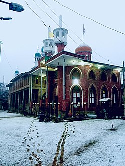
As of December 2020, there are numerous Medical shops and stores present in the village of Ichgam. The Primary Health Centre Ichgam is located at Kalbal, the north-western part of Ichgam. [18]

This image depicts Primary Health Center Ichgam. Photo taken in January 2021 PHC Ichgam in January 2021.jpg
This image depicts Primary Health Center Ichgam. Photo taken in January 2021

Attractions

The shrine of Haztat Abbas is located in Bungam area of the village Ichgam. It is also called Roza Hazrat Abul Fazel Abbass in the native language of the village. Every Thursday, a large number of people from the Shia sect of Islam visit here. It is one of the biggest landmark in the village. [19]

The shrine of Hazrat Abbas in Ichgam. Roza Hazrat Abbas Ichigam.jpg
The shrine of Hazrat Abbas in Ichgam.

Sports

Cricket, football, and badminton are the most played sports in Ichgam. Cricket, being the most popular sport in India, is also played on a large scale in Ichgam. In brick kilns, on playgrounds; anywhere we can see the children and adults of Ichgam playing cricket in mid summer. Tournaments are organized and people take a part in them by spectating, cheering or by directly participating in them.[ citation needed ]

People playing cricket in Brick kilns in Ichgam People playing cricket in Ichigam.jpg
People playing cricket in Brick kilns in Ichgam

Transport

Roads

Ichgam town falls on Budgam- Khansahib road. It is connected to many other villages and townships by a network of roads. To link Ichgam with Ompora, Zori Bhag, Qazi Bagh and Budgam internally, a new link road is being built by the government. This link will be completed by 2021 and will reduce distance between these places.[ citation needed ]

Roads in the Ichgam village are Macadamized but still some roads are not properly built. In ending 2020, some roads near Roza Hazrat Abbass (as) were Mecadamized.

Railway

To present date, there is no railway line connecting Ichgam with other places. The nearest railway station to the Ichgam village is Budgam railway station, located in Ompora, nearly 2.5 km (1.6 mi) away from district headquarters, Budgam.

Airport

The nearest airport to Ichgam is Srinagar International Airport, also called Budgam Airbase.

Old suffering

Prior to December 2020, the villagers of Ichgam used to face a routinely problem. The Airforce Base Camp is located next to the Sheikh ul-Alam International Airport . The gunshots that came from this camp used to hit many houses in Wolina, a part of Ichgam. On 11 December 2020, a female inhabitant (Fatima Begum) was hit by the bullet in her right leg while she was washing vegetables in her kitchen. [20] The bullet had pierced the roof of her house and had been fired by the Airforce personnel during their routine firing drills. It was the daily routine of the air force personnel to conduct their firing drill in the same direction as of the Wolina area of the village. [21] This had put the lives of villagers at the risk of death. Even after reaching many officials, nobody seemed to care about the ordeals of villagers.

The injury of Fatima sparked off a protest in Ichgam. [22] Many people (men and women) blocked the Budgam-Khansahib and Budgam-Chadoora road demanding a quick action against Air force personnel who are involved in the incident. [23] Many officials including Deputy Commissioner Budgam, SHO Budgam and the Tehsildar also visited the place after and during the protests. [24]

Later on an FIR was filed by the Police Station Budgam and the routine of firing drill was closed by the administration. [24] [25] [26]

Telecom services

The Ichgam village is connected through telecom services to the entire world. Airtel, Bsnl, Vodafone, and Reliance Jio are the main telecom service providers in this area. On 21 February 2018, Aircel stopped its services in the whole country. The local subscribers also affected in this village. [27]

Religions
ReligionPercentage
Muslims
98.71%
Hindu
0.98%
Others
0.31%
Distribution of population on religion. [28]
Demography
GenderPercent
Male
51.00%
Female
49.00%
Male and female population

See also

Notes

  1. This information about Ichgam is as per the reports released by the Government of Jammu and Kashmir in 2011 in accordance with the census of India.

Related Research Articles

Magam is a tehsil in central Kashmir's Beerwah sub-district. It is also a town, notified area committee, and a block in Budgam district in the Indian administered union territory of Jammu and Kashmir. It is 11 km (6.8 mi) away from sub-district headquarter Beerwah and 20 km (12 mi) away from Srinagar, the summer capital of Jammu and Kashmir. Magam is the top business hub in this locality, located on the way to Gulmarg. Magam comes both in baramulla district and budgam which makes this famous across these districts for business. The Idara Abu Fazal Abbas Islamic Library, opened in Magam in 1985, is the largest Islamic private library in Jammu and Kashmir.

<span class="mw-page-title-main">Beerwah, Jammu and Kashmir</span> Town in Jammu and Kashmir, India

Beerwah also pronounced as Beeru is a subdistrict, tourist destination and one of the oldest towns of Jammu and Kashmir and a municipal committee in Budgam district in the Indian administered union territory of Jammu and Kashmir. It is also one of the oldest tehsils of Jammu and Kashmir with one of the largest towns in Budgam district. Beerwah is 27 km (17 mi) away from the summer capital Srinagar via Bemina, 31 km (19 mi) via Magam, 33 km (21 mi) via Soibugh and 35 km (22 mi) via Budgam. Beerwah subdistrict has 4 tehsils namely Beerwah, Magam, Narbal and Khag. Beerwah is located along the banks of River Sukhnaag.

<span class="mw-page-title-main">Budgam district</span> District of Jammu and Kashmir administered by India

Budgam district is an administrative district of Indian-administered Jammu and Kashmir in the disputed Kashmir region. Created in 1979 with its headquarters at the town of Budgam, it is the district with the largest population of Shia Muslims in the Kashmir valley.

<span class="mw-page-title-main">Rathsun</span> Village in Jammu and Kashmir, India

Rathsun or Rathsoon is a village and block located in the Jammu and Kashmir's Budgam district. It is situated at the base of the Pir Panjal Range of the Himalayas. It falls under the administrative division of tehsil Beerwah one of the nine tehsils of district Budgam. It is about 23.7 kilometres (14.7 mi) via Beerwah-Budgam Road from district headquarters Budgam, 7 km (4.3 mi) from sub-district headquarters Beerwah. Known as the Gateway of Doodhpathri and Gateway of Tosamaidan, it is situated 29 km (18 mi) away from Srinagar, the summer capital of Jammu and Kashmir. Magam, known as the Business Hub of Budgam district and the Gateway of Gulmarg, is nearest town to Rathsun.

Kanihama, formerly known as Gund Kawarhama, is a village situated on the Srinagar-Gulmarg road in the Budgam district of Jammu and Kashmir in India. The Kani Shawls produced in the area were given a geographical indication status by the government of Jammu and Kashmir, making it illegal to sell shawls made outside of the Kanihama area as Kani shawls.

Nussu is a village in the district Budgam, tehsil Beerwah in the Indian administered union territory of Jammu and Kashmir. It is located about 29 km (18 mi) west of the district headquarters, Budgam, and about 34 km (21 mi) west of union territory capital Srinagar.

Wahabpora is a village in district Budgam in Indian administered union territory of Jammu and Kashmir, India. Situated on the banks of Aihaji River, Wahabpora is about 10 kilometres (6.2 mi) away from the district headquarters Budgam and 21 kilometres (13 mi) from Srinagar, the summer capital of Jammu and Kashmir. The village Wahabpora consists of about six mohallahs— Peer Mohallah, Taingapora, Watipora, Ganaiepora, New Colony and Chinar colony.

It is necessary to describe that Chinar colony was a part of Mosviabad and Al-Mehdi Chowk is the famous region of Chinar colony, the colony which is the central part of the village where five big chinars, about the age five hundred years old are present. The brother in law of Mughal King Jahangir and that time Governor of Kashmir Asif Khan had planted these five chinars. Chinar Garden of Wahabpora is also known as “Asif Ali Khan Bagh”. Gariend is the neighbouring village to Wahabpora. Famous plane crushing event occurred near this place is also known as Gariend-Wahabpora plane crashing event-2019.

<span class="mw-page-title-main">Khag, Jammu and Kashmir</span> Tehsil in Jammu and Kashmir, India

Khag is a tehsil in and block in the Beerwah sub-district of the Budgam district in the Indian union territory of Jammu and Kashmir. It is 8.8 km (5.5 mi) away from sub-district headquarter Beerwah and 35 km (22 mi) away from Srinagar, the summer capital of Jammu and Kashmir.

Aripanthan is a village and panchayat halqa in Beerwah tehsil of Budgam district in the Indian union territory of Jammu and Kashmir. It is situated at the centre of tehsil Beerwah and tehsil Magam. It is located about 27 km (17 mi) west from summer capital of Jammu and Kashmir, Srinagar and about 28 km (17 mi) north from district headquarters in Budgam.

<span class="mw-page-title-main">Doodhpathri</span> Hill Station in Jammu and Kashmir, India

Doodhpathri is a tourist destination and a hill station located in the Khansahib tehsil of the Budgam district of Jammu and Kashmir, India. Situated at an altitude of 2,730 metres (8,960 ft) from sea level, it is located at a distance of 42 km (26 mi) from Jammu and Kashmir's summer capital, Srinagar, and 30 km (19 mi) from district headquarters, Budgam.

Badran is a village located in district Budgam in the Indian administered union territory of Jammu and Kashmir.

Ompora, locally known as "Wompur", is a municipality area of district Budgam. It is 9 km (5.6 mi) from the city centre, Lal Chowk. It is located on the Srinagar-Budgam road, roughly 3 km (1.9 mi) from Airport road. It is one of the highly populated area of Budgam municipality in district Budgam.

Gariend Kallan is a village in Budgam district situated in Jammu and Kashmir, India. It is only 8 km (5.0 mi) from Budgam and 13 km (8.1 mi) from Srinagar. It is bordered by Wahabpora, Garandkhurd, Chattabug, Soibug and Wadwan.

Waripora Bangil is a village located in the town of Kunzer in the Baramulla district of the Indian-administered union territory of Jammu and Kashmir. It is situated 40 kilometres (25 mi) east of the district headquarters of Baramulla and 20 kilometres (12 mi) west of the capital city of Srinagar.

Khan Sahib is a town sub-district and a notified area committee in Budgam district in the central Kashmir, union territory of Jammu and Kashmir, India. In 2008, Government Degree College, Khansahib was established in the town to cater to the needs of rural population.

Soibugh is a town in Budgam district in the Indian-administered union territory of Jammu and Kashmir. It is 8.5 km (5.3 mi) from the summer capital of Jammu and Kashmir, Srinagar. It is one of the highly populated area of district Budgam. Soibugh is one of the 17 blocks of Budgam district.

<span class="mw-page-title-main">Aarizal</span> Village in Jammu and Kashmir, India

Arizal is a village in Budgam district in Kashmir region of Indian Union Territory Jammu and Kashmir. It is situated at the base of the Pir Panjal Range of the Himalayas, in the Sukhnag Valley. It falls under the administrative division of tehsil Khansahib, which is one of the nine tehsils of district Budgam. It lies at a distance of about 35 kilometres (22 mi) from the district headquarters Budgam, 16 kilometres (9.9 mi) from the sub-district headquarters Khansahib, and 45 kilometres (28 mi) away from Srinagar, the summer capital of Jammu and Kashmir.

<span class="mw-page-title-main">Chewdara</span> Village in Jammu and Kashmir

Chewdara or Chivdora, is a village in the Rathsun block of the Beerwah tehsil in Budgam district of Jammu and Kashmir, India. It is located 21 km (13 mi) towards west of the Budgam district headquarters, 3 km (1.9 mi) from Beerwah and 23 km (14 mi) from the winter capital Srinagar. Chewdara has two panchayats, Chewdara-A and Chewdara-B.

<span class="mw-page-title-main">Nilnag Lake</span> Tourist destination in Kashmir

Nilnag is a freshwater lake 5 km (3.1 mi) away from Yousmarg in Budgam district of Jammu and Kashmir, India. It is around 47 km (29 mi) away from Srinagar, the summer capital of the union territory. The lake is famous for its turquoise water. The route from Yousmarg is rather difficult and unmotorable and goes through a dense forest. The lake's crystal-clear blue water gave it its name: nag stands for lake and nil for the blue colour. The location is a great for picnic spot.

References

  1. "The Jammu and Kashmir Official Languages Act, 2020" (PDF). The Gazette of India. 27 September 2020. Retrieved 27 September 2020.
  2. "Parliament passes JK Official Languages Bill, 2020". Rising Kashmir. 23 September 2020. Archived from the original on 24 September 2020. Retrieved 30 May 2021.
  3. Masood, Bashaarat (31 July 2015). "Wedding bells ring in communal harmony in Kashmir". The Indian Express. Retrieved 1 March 2021.
  4. "Ichgam, Budgam" (PDF). cdn.s3waas.gov.in. Retrieved 14 January 2021.
  5. "List of panchayat halqas of district Budgam" (PDF). Retrieved 14 January 2021.
  6. Lawrence, Sir Walter Roper (2005). The Valley of Kashmir. Asian Educational Services. ISBN   978-81-206-1630-1.
  7. 1 2 3 4 5 Population, Ichgam (18 January 2021). "Population of Class V Census Towns and Villages in India". Census of India. Retrieved 18 January 2021.
  8. "GBHSS Ichgam (Dreygam)". Schools. Retrieved 26 January 2021.
  9. "BHSS Ichgam, UDISE Plus". UDISE Plus. Archived from the original on 17 June 2022. Retrieved 26 January 2021.
  10. "Schools in Budgam" (PDF). ceobudgam.in. Retrieved 26 January 2021.
  11. "BHSS Ichgam" (PDF). JK Education. Retrieved 26 January 2021.
  12. "Directory of Schools" (PDF). mospi.nic.in. Retrieved 26 January 2021.
  13. "IPS Ichgam, UDISE Plus". UDISE Plus. Archived from the original on 17 June 2022. Retrieved 26 January 2021.
  14. "UDISE codes of Schools of Budgam". UDISE. Retrieved 26 January 2021.
  15. "IPS Ichgam, Educational Trust Kashmir". Ichgam: Education Trust Kashmir. Archived from the original on 21 January 2021. Retrieved 26 January 2021.
  16. "Schools in Ichgam,Budgam, J&K". icbse. Retrieved 26 January 2021.
  17. "Schools in Ichgam". study4sure. Retrieved 26 January 2021.
  18. "PHC Ichgam Primary Health Center - Address and Reviews - Govt. Building, Kalbal Ichigam, Near Imi Middle School, Budgam, Badgam, Jammu & Kashmir - Phone Number". aarogya.us. Retrieved 17 January 2021.
  19. "Roza Hazrat Abul Fazel Abbas a.s Ichigam". vymaps. Retrieved 17 January 2021.
  20. correspondent, Reader (11 December 2020). "Woman injured during 'stray bullet' from IAF firing range in Budgam village". Kashmir Reader. Retrieved 7 February 2021.
  21. "Protest against bullet injury to woman in Budgam village". Kashmir Media Service. 20 December 2020. Retrieved 7 February 2021.
  22. "locals protest in Budgam village Archives". Kashmir Age. Retrieved 7 February 2021.
  23. Haq, Naveed ul. "Woman recieves[sic] bullet injury, locals protest in Budgam village | KNO". Kashmir News Observer. Retrieved 7 February 2021.
  24. 1 2 "'Every House Hit by Bullets': Budgam Villagers Protest Against Air Force's Firing Drills". thewire.in.
  25. "Woman injured by bullet from Air Force firing range in Budgam". Greater Kashmir. 11 December 2020.
  26. "65-year-old woman injured after hit by "stray" bullet in Budgam". The Kashmirwalla. 11 December 2020.
  27. "34 lakh mobile subscribers in lurch: Is Aircel going Tata Tele way in J&K;?". Greater Kashmir. Archived from the original on 23 February 2018. Retrieved 26 January 2021.
  28. "Census of India (Jammu and Kashmir)". Census of India.
  1. Vale of Kashmir
  2. Official Website of Budgam District
  3. Official Website of Educational Trust Kashmir