
The McDonnell Douglas F-15 Eagle is an American twin-engine, all-weather tactical fighter aircraft designed by McDonnell Douglas. Following reviews of proposals, the United States Air Force selected McDonnell Douglas's design in 1969 to meet the service's need for a dedicated air superiority fighter. The Eagle first flew in July 1972, and entered service in 1976. It is among the most successful modern fighters, with over 100 victories and no losses in aerial combat, with the majority of the kills by the Israeli Air Force.

The Lockheed T-33 Shooting Star is a subsonic American jet trainer. It was produced by Lockheed and made its first flight in 1948. The T-33 was developed from the Lockheed P-80/F-80 starting as TP-80C/TF-80C in development, then designated T-33A. It was used by the U.S. Navy initially as TO-2, then TV-2, and after 1962, T-33B. The last operator of the T-33, the Bolivian Air Force, retired the type in July 2017, after 44 years of service.

Anantnag district is a district in the Indian union territory of Jammu and Kashmir. It is one of ten districts which make up the Kashmir Valley. The district headquarters is Anantnag city. As of 2011, it was the third most populous district of Jammu and Kashmir, after Jammu and Srinagar.

Walker Air Force Base is a closed United States Air Force base located three miles (5 km) south of the central business district of Roswell, New Mexico. It was opened in 1941 as an Army Air Corps flying school and was active during World War II and the postwar era as Roswell Army Air Field. During the early years of the Cold War, it became the largest base of the Strategic Air Command. It is also known for the Roswell UFO incident, an event that occurred on 4 July 1947. It is alleged that a "flying disc" crashed during a severe thunderstorm near the base at Corona, New Mexico.

Awantipora or Avantipur or Aavantipur, known as Woontpor in Kashmiri, is a town on the banks of the River Jehlum in the Pulwama district of the Indian union territory of Jammu and Kashmir. It is on the Jammu-Srinagar National Highway, south of Srinagar and north of Anantnag. Awantipora was named after the Kashmiri king Avantivarman and has the ruins of two 9th century Hindu temples built by him.

Reasi is a town and a notified area committee and tehsil in the Indian union territory of Jammu and Kashmir. Situated at the bank of River Chenab, it is the headquarters of the Reasi district. In the eighth century, Reasi was a part of the Bhimgarh state established by Bhim Dev. The name Reasi is derived from the town's old name "Rasyal".

Tral is a town, sub-district and a notified area committee in Pulwama district of Jammu and Kashmir which is situated at a distance of 11 km (6.8 mi) from Awantipora. Tral is situated around 40 km (25 mi) from summer capital Srinagar and 20 km (12 mi) from district headquarters Pulwama. Tral is the largest area committee in Pulwama district after Pulwama followed by Awantipora and Pampore sub-districts.

The Stinson L-1 Vigilant was a 1940s American light observation aircraft built by the Stinson Aircraft Company at Wayne, Michigan. The aircraft was operated by the United States Army Air Corps as the O-49 until 1942.

The Defence Security Corps (DSC), is a corps of the Indian Army responsible for providing security cover to the defence installations of the three services and other sensitive installations. The DSC troops are sanctioned and attached to various bases/installations to ensure protection against sabotage and pilferage. It is the sixth largest corps of the Army.

Bellefleur is a community in the Canadian province of New Brunswick. It is situated in Saint-Léonard, a parish of Madawaska County. Being on the east bank of the Saint John River, Bellefleur is less than a mile away from the United States border.

Hirekudi is a village in the southern state of Karnataka, India. It is located in the Chikodi taluk of Belgaum district in Karnataka.
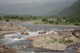
The Poonch River is a tributary of the Jhelum River that flows through Jammu and Kashmir in India, and Azad Jammu and Kashmir in Pakistan.

The Antonov An-74 is a Soviet/Ukrainian transport aircraft developed by Antonov. It is a variant of the An-72.
Amlar is a village in the Indian union territory of Jammu and Kashmir. It lies at a distance of almost 35 km from Srinagar and 6 km from main Tral town and 5 km from Awantipora. Its nearby villages are Nowpora, Lariyar and Poshwan. On the Khandaypora side, it is surrounded by a low mountain (Wudur). Amlar consists of various mohallas like Shiekhpora, Khandaypora, Dar mohalla, Khudpora, Kumar Mohalla. In addition to this, there is a place, Nagrad, which is considered a part of Sheikhpora.

Awantipora railway station is situated in notified area of Awantipora in the Pulwama district. It is the headquarters of Pulwama division of Northern railway zone. It is one of the four stations in Pulwama district, the others being Pampore railway station, Kakapora railway station and Panchgam railway station respectively.
Pampore railway station is the railway station on the Jammu–Baramulla line in the Indian union territory of Jammu and Kashmir. It is one of the four stations in Pulwama district, the others being Awantipora railway station, Kakapora railway station and Panchgam railway station respectively.
Kakapora railway station is a railway station in the Northern Railway zone of Indian Railways. It is one of the four stations in Pulwama district, others being Awantipora railway station, Pampore railway station and Panzgam railway station respectively.

Padgampora, also known as Padgampur, is a village in Awantipora tehsil in Pulwama district of Jammu and Kashmir in India. It is located 14 km (8.7 mi) towards East from District headquarters Pulwama. 14 km (8.7 mi) from Tral. 25 km from State capital Srinagar.
Baragam, also known as Baragram, is a village in the Tral block of Pulwama district in the Indian union territory of Jammu and Kashmir. It is a small village located at 33°53′28.2″N75°03′26.9″E. It lies almost 35 km (22 mi) from Srinagar, and 17 km (11 mi) from district headquarters, Pulwama.
Renzipora is a village in Awantipora tehsil of district Pulwama, Jammu and Kashmir, India. Almost at an equal distance from District Pulwama and Tehsil Awantipora. Renzipora is settled in a lush vale in the shadow of small hills drained by an irrigation Kul.