Aalo, formerly Along, is a census town and headquarter of the West Siang district district of the Indian state of Arunachal Pradesh. It is located 137 kilometres (85 mi) from Likabali, which is at the border of Assam and Arunachal Pradesh.

Gauchar is a Hill Town sort of a valley town located in Karnaprayag tehsil within Chamoli district of Uttarakhand state in India. Gauchar is situated on the left bank of river Alaknanda and is en route to the celebrated holy destination of Badrinath. It is well known for being one of the cleanest place in country. It has previously topped Swachta sarvekshan best ganga town award. Situated at an altitude of 800 metres (2,620 ft) above the sea level, Gauchar is surrounded by seven mountains. Gauchar is well known for its historic trade fair and airstrip. Gauchar town known for its great work to curb loss of lives in 2013 flood disaster of Uttarakhand. This town is unique in terms of its geographical location and topography. Gauchar is located on one of the largest pieces of flatland in this mountainous region of Uttarakhand. Education institution in Gauchar includes a beautiful Kendriya Vidyalaya adjacent to the main playground.
Daporijo Airport is located at Daporijo in the state of Arunachal Pradesh, India. Daporijo used to have scheduled services in the 1980s and early 1990s from Vayudoot. The airport had flights to Guwahati and Dibrugarh on Dornier 228 aircraft. Currently, there is no scheduled commercial air service to the airport, although the airport is used by the Indian Army. The Airports Authority of India (AAI) plans to develop the airport for operation of ATR-42/ATR-72 type of aircraft.

Thoise or Thoise Air Force Station is a military airfield and small village in Nubra region of Ladakh, India, occupying the only large piece of flat land in the area. The airstrip is a critical facility enabling a quick inflow of men and material from the Indian interior to Siachen, a glacier, helipad and battleground near the Actual Ground Position Line between India and Pakistan.
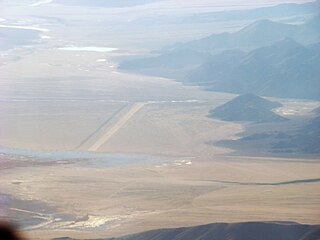
Fukche Advanced Landing Ground is an airfield in the Demchok sector of the union territory of Ladakh, India. It was built shortly before the 1962 Sino-Indian War and was revived in 2008. It is located adjacent to Koyul, 34 km northwest of Demchok.
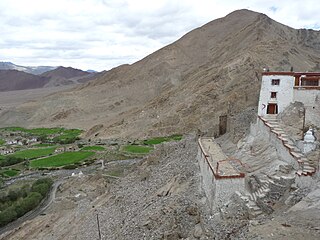
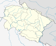
Nyoma is a principal village of southern Ladakh in India, the headquarters of an eponymous subdivision, tehsil, community development block and Indian Air Force Base in the Leh district. It is located on the bank of the Indus river after its 90-degree bend near Dungti east of Nyoma and before the valley narrows to a gorge near Mahe northwest of Nyoma. The Nyoma tehsil and subdivision cover all of southern Ladakh, including the Rupshu plains south of Nyoma, the Indus valley of Skakjung north of Nyoma, and the Hanle valley. Nyoma gompa, a Buddhist monastery, is located on the hill slope north of the village.
Chinyalisaur is a small town and tehsil headquarters in the Uttarkashi district of the Indian state of Uttarakhand.

Pithoragarh Airport, also known as Naini–Saini Airport, is a domestic airport serving Pithoragarh and Kumaon division in Uttarakhand, India. It is located at Naini-Saini, 4.5 km (2.8 mi) north-east from the city centre. The airport has been designated to be developed as a greenfield airport under the government's UDAN Scheme.
Deesa Airport is an airport in Deesa, Gujarat. It is managed by the Airports Authority of India.

Pakyong Airport is a non-operational domestic airport near Gangtok, the capital of Sikkim, India.

Operation Surya Hope was the Indian Army’s Central Command response to the June 2013 North India floods in Uttarakhand.
Operation Rahat was the name given to the Indian Air Force's rescue operations to evacuate civilians affected by the 2013 North India floods. Thousands of pilgrims in transit in the hill states of Uttarakhand and Himachal Pradesh were stranded in various valleys. It was one of the largest operations of the Indian Armed Forces in several decades. and IAF claims it to be the biggest civilian rescue operation in the world carried out by any air force using helicopters. During the first phase of the operation From 17 June 2013, the IAF airlifted a total of 19,600 people - flying a total of 2,140 sorties and dropping/landing a total of 3,82,400 kg of relief material and equipment. Air Vice Marshal (then) SRK Nair was the IAF coordinator on ground at Uttarakhand.
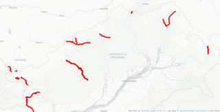
Arunachal Frontier Highway (AFH), officially notified as the National Highway NH-913 and also called Bomdila-Vijaynagar Highway (BVH), connecting Bomdila Airstrip ALG & HQ in northwest to Vijaynagar Airstrip ALG & HQ in southeast via Nafra HQ-Sarli HQ-Huri Helipad ALG & HQ-Nacho HQ-Mechuka Airstrip ALG & HQ-Monigong HQ-Jido -Hunli HQ-Hayuliang Airstrip ALG HQ-Chenquenty-Hawai HQ-Miao HQ including 800 km greenfield section and network of new tunnels & bridges, is a 2-lane paved-shoulder under-construction national highway along the India-China LAC-McMahon Line border in the Indian state of Arunachal Pradesh. The 1,748 km-long (1,086 mi) highway itself will cost ₹27,000 crore and total cost including 6 additional inter-corridors is ₹40,000 crore. In some places, this highway will run as close as 20 km from the LAC. To be constructed by MoRTH in 9 packages, all packages will be approved by the end of fy 2024-25 and construction will be completed in 2 years by 31 March 2027. Of the total route, 800km is greenfield, rest brownfield will be upgraded and tunnels will be built. This highway in the north & east Arunachal along the China border, would complement the Trans-Arunachal Highway and the Arunachal East-West Corridor as major highways spanning the whole state, pursuing the Look East connectivity policy.
Tawang Air Force station in Arunachal Pradesh in India has a functional heliport and fixed-wing "Advanced Landing Ground" (AGL) capable of handling Lockheed Martin C-130J Super Hercules transport aircraft. The Indian Air Force (IAF) has since 2016 upgraded 8 ALG in Arunachal Pradesh and made those operation by 2018, all of which has been offered for the operation of civil helicopter and flights for tourism and the UDAN scheme.
Bangarmau Airstrip Naseerpur Bhikhan नसीरपुर भिक्खन is an airstrip located at Village Naseerpur Bhikhan in Unnao district of Uttar Pradesh, India. The airstrip is a part of the Agra Lucknow Expressway and belongs to the Indian Air Force. Naseerpur Bhikhan Air Strip Bangarmau is first expressway air strip in India; fighter plane Mirage 2000,Jaguar has successfully landed here ,. Airstrip length is more than 3 km On 27 October 2017, the Indian Air Force aircraft like Mirage 2000 fighter planes, heavy-lift and all-weather Hercules K-130 aircraft and transport aircraft AN-30 on this airstrip located in the border of village Nasirpur Bhikkhan of Bangarmau. Created history by landing 20 fighter planes on the airstrip of this expressway This airstrip of Nasirpur Bhikkhan is very important from strategic point of view. China and Pakistan border is very close from here; Nasirapur air strip is India's most modern air strip located on Bangarmau Expressway. The view around this air strip is very beautiful and scenic. This air strip is situated in the middle of lush green fields. It has also become a selfie point for the people. Expressway People passing by stop here for some time and take pictures etc.
Mechuka Advanced Landing Ground is an Indian Air Force airstrip located at Mechuka in Shi Yomi district of Arunachal Pradesh, India. It is an Advance Landing Ground (ALG) of Indian Air Force.
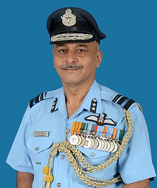
Air Vice Marshal Suryakant Chintaman Chafekar AVSM, SC is a retired Indian Air Force (IAF) officer who served as the Senior Air and Administration Staff Officer, Maintenance Command, IAF, from 1 July 2016 until he retired on 30 September 2017. He was the commanding officer of No. 48 Squadron IAF. During his career he landed Antonov An-32 aircraft on High Altitude Advanced Landing Grounds (HAALG)s in Daulat Beg Oldi, Fukche and Nyoma.
Walong Advanced Landing Ground is an Indian Air Force airstrip located at Walong on the banks of Lohit River in Anjaw District of Arunachal Pradesh, India. It is nearly 50 km north of district headquarter at Hawai, nearly 30 km south of India-China LAC, and 70 km southwest of Diphu Pass near India-China-Myanmar tri-junction.
India–China Border Roads is a Government of India project for developing infrastructure along the Sino-Indian border by constructing strategic roads, including bridges and tunnels. The ICBR project is largely in response to Chinese infrastructure development along the borderlands with India.