Walong

Last updated

Walong
town
Walong War Memorial.JPG
Walong War Memorial
India Arunachal Pradesh location map.svg
Red pog.svg
Walong
Location in Arunachal Pradesh, India
Coordinates: 28°8′N97°1′E / 28.133°N 97.017°E / 28.133; 97.017 Coordinates: 28°8′N97°1′E / 28.133°N 97.017°E / 28.133; 97.017
CountryFlag of India.svg  India
State Arunachal Pradesh
District Anjaw district
  Density13/km2 (30/sq mi)
Languages
  Official English
Time zone UTC+5:30 (IST)
Nearest city Tinsukia
Lok Sabha constituency Arunachal East
Vidhan Sabha constituency Hayuliang
Climate Cwa

Walong is an administrative town and the headquarters of eponymous circle in the Anjaw district in eastern-most part of Arunachal Pradesh state in India. It also has a small cantonment of the Indian Army. Walong is on banks of Lohit River, which enters India 35 km north of Walong at India-China LAC at Kaho pass.

Contents

Walong is also the easternmost town in mainland India. It is 20 km south of Kibithu, 60 km west of Diphu Pass (near India-China-Myanmar tri-junction), and 90 km north of district headquarter at Hawai. Anjaw district was carved out of Lohit District in 2004.

Geography

Walong
Walong
Walong

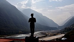
Walong lies on the west bank of the Lohit River, a tributary of the Brahmaputra, approximately 20 kilometres south of the Tibetan border. The forest around Walong is rich in wildlife. Rare mammals such as Mishmi takin, Red goral and Leaf muntjac occurs while among birds there is the rare Sclater's Monal. [1] A flying squirrel, the Mishmi Hills Giant Flying Squirrel (Petaurista mishmiensis) also occurs in this district. [2]

History

The enquiries of British officials in 1911 revealed that Walong had been established by Miju Mishmis many years earlier for cattle-rearing and as a refuge for Tibetans who came down or ran away from the north. In the vicinity of Walong, several abandoned villages were found, where Tibetans had lived and then returned to Tibet. [3]

1911 Chinese encroachments

Simla Convention maps - the light blue line represents the initial Chinese claims, the dark blue line was the eventually agreed boundary of Chinese control Simla Convention - contending claims in Kham.jpg
Simla Convention maps – the light blue line represents the initial Chinese claims, the dark blue line was the eventually agreed boundary of Chinese control

During Zhao Erfeng's campaigns in southeastern Tibet (Kham), Chinese troops arrived at Rima on the Tibetan border. [3] After expelling all the Tibetan officials from there, they entered the Walong area and erected a boundary plank at a location called Menilkrai three miles south of Walong, claiming the area to be part of China. After some coaxing, the headman of Walong admitted to the British political officer in 1914 that the Chinese had sent for him and told him to inform the British officials of their claims. [4] The political officer, T. P. M. O'Callaghan, had the plank and the post promptly removed. [5]

Shortly after the Zhao Erfeng's campaigns, the Qing dynasty fell and the Chinese lost all authority in Tibet. Nevertheless, during the 1914 Simla Conference, the Chinese made renewed claims to the Walong area as being part of China (as part of western Kham). The claims were rejected by the Tibetan and British delegates. The McMahon Line boundary, agreed between Tibet and British India, ran a little south of Rima.

1962 war

Battle of Walong memorial at 'Helmet Top'. (helmets and other military gear were found at this location). Helmet Top Walong Memorial Arunachal Pradesh.jpg
Battle of Walong memorial at 'Helmet Top'. (helmets and other military gear were found at this location).

In autumn of 1962, during the Sino-Indian War, Walong was the scene of the Battle of Walong, where the Indian Army 11th Infantry Brigade battled the Chinese advances. [7]

The killed and wounded numbered 642 Indians and 752 Chinese. [8] Indians were defeated at Walong, however the Chinese withdrawal allowed India to regain the territory. [6]

A canopied memorial to the Indian war dead of 1962 was erected next to the airstrip with the following verses composed by a Walong veteran inscribed on it: [6]

The sentinel hills that round us stand
bear witness that we loved our land.
Amidst shattered rocks and flaming pine
we fought and died on Namti Plain.
O Lohit gently by us glide
pale stars above us softly shine
as we sleep here in sun and rain.

Transport

Walong is approximately 200 km. by road from the district headquarters town of Tezu. It had an Advanced Landing Ground (ALG) which was capable of taking Otters and Caribous during the 1962 Sino-Indian War. Thereafter, it remained abandoned for a long time till 2013 when reconstruction of ALG began. The reconstructed ALG was inaugurated on 23 October 2015. [9] There is an operational helipad.

Map

Related Research Articles

Arunachal Pradesh State in north-eastern India

Arunachal Pradesh is an Indian state in Northeast India. It was formed from the erstwhile North-East Frontier Agency (NEFA) region, and became a state on 20 February 1987. It borders the states of Assam and Nagaland to the south. It shares international borders with Bhutan in the west, Myanmar in the east, and a disputed border with China in the north at the McMahon Line. Itanagar is the state capital of Arunachal Pradesh. Arunachal Pradesh is the largest of the Seven Sister States of Northeast India by area. Arunachal Pradesh shares a 1,129 km border with China's Tibet Autonomous Region.

McMahon Line Boundary between the Tibetan region of China and India

The McMahon Line is the boundary between Tibet and British India as agreed in the maps and notes exchanged by the respective plenipotentiaries on 24-25 March 1914 at Delhi, as part of the 1914 Simla Convention. The Republic of China was not a party to the McMahon Line agreement, but the line was part of the overall boundary of Tibet defined in the Simla Convention, initialled by all three parties and quickly repudiated by the government of China. The Indian part of the Line currently serves as the de facto boundary between China and India, although its legal status is disputed by the People's Republic of China. The Burmese part of the Line was renegotiated by the People's Republic of China and Myanmar.

Mishmi people Ethnic group

The Mishmi or Deng people of Tibet and Arunachal Pradesh are an ethnic group comprising mainly three tribes: Idu Mishmi ; Digaro tribe, and Miju Mishmi. The Mishmis occupy the northeastern tip of the central Arunachal Pradesh in Upper and Lower Dibang Valley, Lohit and Anjaw Districts. The three sub-divisions of the tribe emerged due to the geographical distribution, but racially all the three groups are of the same stock. The Idu are also known as Yidu Lhoba in Tibet and often referred as Chulikatas in Assam. The Idus are primarily concentrated in the Upper Dibang Valley and Lower Dibang Valley district and parts of the northern part of Lohit district of Arunachal Pradesh in India. Taraon, also called Digaru Mishmis, are distributed in the hill and the foothills between the Dibang, Digaru and the Lohit rivers. Kamans are also known as the Miju Mishmis; they live between the Lohit and the Kambang rivers in the foothills and in the Mishmi Hills on both sides of the Lohit river right up to the frontiers to Rima. There are around 30,000 of them in Arunachal Pradesh.

Dibang Valley district District of Arunachal Pradesh in India

Dibang Valley (Pron:/dɪˈbæŋ/) is a district of Arunachal Pradesh named after the Dibang River or the Talon as the Mishmis call it. It is the least populated district in India and has an area of 9,129 square kilometres (3,525 sq mi).

Lohit district District of Arunachal Pradesh in India

Lohit is an administrative district in the state of Arunachal Pradesh in India. The district headquarters is located at Tezu. As of 2011 it is the third most populous district of Arunachal Pradesh, after Papum Pare and Changlang.

West Siang district District of Arunachal Pradesh in India

West Siang is an administrative district in the state of Arunachal Pradesh in India.

Anini District Headquarters in Arunachal Pradesh, India

Anini is the headquarters of the Dibang Valley district in the state of Arunachal Pradesh in Northeast India. Anini was also the district headquarters of the undivided Dibang Valley district. It is a small underdeveloped town, mainly because of its remoteness. Yet, it still has basic road and air links to the rest of India. The Idu Mishmi tribal people constitute a majority here. The town is fully dependent on the nearest major settlement, Roing, which is in the Lower Dibang Valley District, for most commercial needs.

The Zekhring are from the Anjaw District of Arunachal Pradesh. They live in the hilly terrain and banks of the Lohit River in the Walong and Kibithoo area. As of 2002, their tribal population stood at 300, and their population included members of an ethnically akin tribe, the Meyor.

Lohit River River in Arunachal Pradesh in India

The Lohit River is a river in China and India, which joins the Brahmaputra River in the state of Assam. It is formed in the Zayul County of the Tibet Autonomous Region, through a merger of two rivers: the Kangri Karpo Chu, which originates in the Kangri Garpo range, and Zayul Chu, which originates to its northeast. The two rivers merge below the town of Rima. The combined river descends through this mountainous region and surges through Arunachal Pradesh in India for 200 kilometres (120 mi) before entering the plains of Assam where it is known as the Lohit River. Tempestuous and turbulent, and known as the river of blood partly attributable to the lateritic soil, it flows through the Mishmi Hills, to meet the Siang (Brahmaputra) at the head of the Brahmaputra valley.

Anjaw district District of Arunachal Pradesh in India

Anjaw District (Pron:/ˈændʒɔ:/) is an administrative district in the state of Arunachal Pradesh in north-east India. It was created district in 2004, by splitting off from the Lohit district under the Arunachal Pradesh Re-organization of Districts Amendment Act. The district borders China on the north. Hawai, at an altitude of 1296 m above sea level, is the district headquarters, located on the banks of the Lohit River, a tributary of the Brahmaputra River. It is the easternmost district in India. The furthest villages towards the border with Chin are Dong, Walong, Kibithu and Kaho.

Hawai, Arunachal Pradesh Town in Arunachal Pradesh, India

Hawai is the district headquarters of the newly created Anjaw District in the state of Arunachal Pradesh in north-east India.

Lower Dibang Valley district District of Arunachal Pradesh in India

The Lower Dibang Valley district (Pron:/dɪˈbæŋ/) is an administrative district in the state of Arunachal Pradesh in northeastern India. It is the tenth least populous district in the country.

Kibithu Village in Arunachal Pradesh, India

Kibithu, also spelled Kibithoo, is a town in Arunachal Pradesh in Anjaw district. It is one of the easternmost permanently populated towns of India, located on the LAC at 28°16′49″N97°01′04″E. It is nearly 70 km north of district headquarter at Hawai, nearly 15 km south of India-China LAC (Kaho), and 40 km west of Diphu Pass near India-China-Myanmar tri-junction. The Lohit River enters India north of Kibithu at Kaho. Nearest air connectivity is 20 km in the south at Walong airstrip in Walong.

Dihang-Dibang Biosphere Reserve Biosphere Reserve in Arunachal Pradesh, India

Dihang-Dibang or Dehang-Debang is a biosphere reserve constituted in 1998. It is in the Indian state of Arunachal Pradesh. The Mouling National Park and the Dibang Wildlife Sanctuary are located fully or partly within this biosphere reserve. The reserve spreads over three districts: Dibang Valley, Upper Siang, and West Siang. It covers high mountains of Eastern Himalaya and Mishmi Hills. The elevation in the reserve ranges up to more than 5,000 metres (16,000 ft) above sea level. An important fact relating to this Biosphere reserve is that it has natural vegetation stretching in an unbroken sequence from the tropics to mountain tundra. The type of vegetation found in this biosphere reserve can be grouped as 1. Sub-tropical broad leafed forests, 2. Sub tropical pine forest, 3. Temperate broad leafed forests, 4. Temperate conifer, 5. Sub-alpine woody shrub, 6. Alpine meadow( mountain Tundra), 7. Bamboo brakes, 8. Grassland. The habitat in Dihang-Dibang ranges from tropical wet evergreen in the river gorges to subtropical, temperate, alpine and permanent snow.

Mechuka Town in Arunachal Pradesh, India

Mechukha or Menchukha is a town, assembly constituency and subdivision, situated 6,000 feet (1,829 m) above sea level in the Mechukha Valley of Yargep Chu/ Siyom River in Shi Yomi district of Arunachal Pradesh state of India. Before the 1950s, Mechuka valley was known as Pachakshiri.

Dibang Wildlife Sanctuary Wildlife sanctuary in India

The Dibang Wildlife Sanctuary is one of the eight wildlife sanctuaries of Arunachal Pradesh, India. It is located in the Upper Dibang Valley district covering an area of 4,149 km2 (1,602 sq mi). The sanctuary is rich in wildlife. Rare mammals such as Mishmi takin, red goral, musk deer, red panda, Asiatic black bear, occasional tiger and Gongshan muntjac occur while among birds there are the rare Sclater's monal and Blyth's tragopan. A flying sqirrel , new to science has been recently discovered from the edge of this sanctuary. It has been named the Mishmi Hills giant flying squirrel. Dibang Wildlife Sanctuary is located fully or partly within Dihang-Dibang Biosphere Reserve

Zahkring is a small language of Arunachal Pradesh in India.

Chaglagam Village in Arunachal Pradesh, India

Chaglagam is a village and the headquarters of an eponymous circle in the Anjaw district in the north-eastern state of Arunachal Pradesh, India.

Walong Advanced Landing Ground Indian Air Force airstrip

Walong Advanced Landing Ground is an Indian Air Force airstrip located at Walong on the banks of Lohit River in Anjaw District of Arunachal Pradesh, India. It is nearly 50 km north of district headquarter at Hawai, nearly 30 km south of India-China LAC, and 70 km southwest of Diphu Pass near India-China-Myanmar tri-junction.

Rima, Tibet Village in Tibet, Peoples Republic of China

Rima is the former capital of the Zayul in the southeastern Tibet Autonomous Region of China. It is on the border with India's Arunachal Pradesh at the confluence of the Rongto Chu and Zayul Chu rivers, which join together to form the Zayul River before it flows into Arunachal Pradesh. Rima was a notable border trading town, which the British contemplated as a location for a trade mart in the Lhasa Convention.

References

  1. Choudhury, Anwaruddin (2008) Survey of mammals and birds in Dihang-Dibang biosphere reserve, Arunachal Pradesh. Final report to Ministry of Environment & Forests, Government of India. The Rhino Foundation for nature in NE India, Guwahati, India. 70pp.
  2. Choudhury, Anwaruddin (2009). One more new flying squirrel of the genus Petaurista Link, 1795 from Arunachal Pradesh in north-east India. The Newsletter and Journal of the RhinoFoundation for nat. in NE India 8: 26-34, plates.
  3. 1 2 Mehra, The McMahon Line and After (1974), p. 83.
  4. Mehra, The McMahon Line and After (1974), pp. 82–83.
  5. Mehra, The McMahon Line and After (1974), pp. 83–84.
  6. 1 2 3 "Census of India 2011: District Census Hanbook Anjaw, Village and Town Directory" (PDF). Directorate of Census Operations, Arunachal Pradesh. p. 9. Retrieved 19 July 2021.
  7. Dutta, AN (15 November 2019). "Battle of Walong — how India fought its only counter-attack in 1962 India-China war". ThePrint. Retrieved 19 July 2021.
  8. Sandhu, Shankar & Dwivedi, 1962 from the Other Side of the Hill (2015), p. 119.
  9. PTI (23 October 2015). "Arunachal Pradesh Walong landing ground ready for operations". IndiaTV News. Retrieved 19 July 2021.CS1 maint: uses authors parameter (link)

Bibliography