Lhoba is any of a diverse amalgamation of Sino-Tibetan-speaking tribespeople living in and around Pemako, a region in southeastern Tibet including Mainling, Medog and Zayü counties of Nyingchi and Lhünzê County of Shannan, Tibet.

Itanagar is the capital and largest town of the Indian state of Arunachal Pradesh. The seat of Arunachal Pradesh Legislative Assembly, the seat of government of Arunachal Pradesh, and the seat of Gauhati High Court permanent bench at Naharlagun are all in Itanagar. Being the hub of all the major economic bases, Itanagar, along with the adjacent town of Naharlagun, comprise the administrative region of the Itanagar Capital Complex Region. This stretches from the Itanagar Municipal limit at Chandranagar Town extended until Nirjuli Town, and is a major junction of cultural, economic, fashion, education and recreational activities.

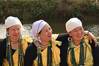
The Adi people are one of the most populous groups of indigenous peoples in the Indian state of Arunachal Pradesh. A few thousand are also found in the Tibet Autonomous Region, where they are called the Lhoba together with some of the Nyishi people, Na people, Mishmi people and Tagin people.
The Indian state of Arunachal Pradesh has a total population of roughly 1.4 million on an area of 84,000 km2, amounting to a population density of about 17 pop./km2. The "indigenous groups" account for about two thirds of population, while immigrants, mostly of Bengali/Hindi belt origin, account for the remaining third.

Donyi-Polo is the designation given to the indigenous religion, of animistic and shamanic type, of the Tani and other Tibeto-Burman peoples of Arunachal Pradesh and Assam in Northeast India. The name "Donyi-Polo" means "Sun-Moon", and was chosen for the religion in the process of its revitalisation and institutionalisation started in the 1970s in response to inroads made by Christianity and the possibility of absorption into Hinduism.

West Siang district is an administrative district in the state of Arunachal Pradesh in India.
Tezu is a census town and the headquarters of Lohit district in the Indian state of Arunachal Pradesh. It is the fifth largest town in Arunachal Pradesh and one of its most developed.

Yingkiong is a town in and the administrative headquarters of Upper Siang district in the Northeast Indian state of Arunachal Pradesh. It is located 250 kilometres (160 mi) north of Itanagar, the capital of the state, and 1 kilometre (0.62 mi) east of the River Siang. According to the 2011 Census, the town has a total population of 8,573.

Aalo, formerly Along, is a census town and headquarter of the West Siang district district of the Indian state of Arunachal Pradesh. It is located 137 kilometres (85 mi) from Likabali, which is at the border of Assam and Arunachal Pradesh.

The Tagins are one of the major tribes of Arunachal Pradesh, India, a member of the larger designation of Tani Tribes. The Tagins refers to a tribe of Northeast India Region. The Tagins are members of the larger designation of Abotani. The Tagins are generally adherents of Donyi Poloism religion.
The Galo are a tribe in Arunachal Pradesh, who are descendants of Abotani. They speak the Tani Galo language. Other names which have been used to reference the Galo tribe in the past include Duba, Doba, Dobah Abor, Gallong Abor, Galong, Gallong Adi, etc. The Galo have been listed as a scheduled tribe under the name Gallong since 1950.

Mechukha or Menchukha is a town, assembly constituency and subdivision, situated 6,000 feet (1,829 m) above sea level in the Mechukha Valley of Yargep Chu/ Siyom River in Shi Yomi district of Arunachal Pradesh state of India. Before the 1950s, Mechuka valley was known as Pachakshiri.
The 'Mopin' or 'Moopin' Festival is an agricultural festival celebrated by the Galo tribe of Arunachal Pradesh, India in particular of the Galo group of tribes which resides in East Siang and West Siang districts. It is a celebration of the harvesting season held in the Galo months of "Lumi" and "Luki", corresponding to March–April and the new year for the Galo tribe. The Galo tribe follow an animist religion called Donyi-Polo.
Longpi is a general reference to two villages in the Ukhrul District of the Indian state of Manipur. Longpi is about 37 kilometres (23 mi) north of Ukhrul, connected by National Highway 202. The two villages together have a population of over 8,000.
The Mising people are a Sino-Tibetan indigenous ethnic group inhabiting the Northeast Indian states of Assam and Arunachal Pradesh. They are part of Tani group of people of Northeast India.
Champhung is a village located extreme west in Ukhrul district, Manipur. The village is connected by an inter village road Via Makuikong and is about 30 kilometers from the district headquarter and 4 Kilometers from Lungchong Maiphei - L.M Block. Champhung is flanked by Tora in the north, Somdal, Phalee and Teinem in the east, Leisan in the south-west and Senapati district in the west.
Si-Donyi is the major festival celebrated among the Tagin tribe of Arunachal Pradesh in North-eastern India. It is celebrated majorly in district headquarter Daporijo, in adjoining town Dumporijo and in Taliha, Siyum areas, also in state capital Itanagar, while in other places also it's being celebrated by Tagin community present there. The festival was first conceptualised in the year 1975 by Late Tatar Uli, who was the main pioneer in inception of Si-Donyi. The other members who bore the responsibilities were Late Tadak Dulom and Popak Bage. The festival was celebrated in the same year under their guidance, and since then, the festival Si-donyi has been celebrated by the Tagin tribe. The first priest who led the ritual was Dubi Nogam. Further the name Si-Donyi was suggested by Shri. Bingsa Kodak.
The BASCON festival is a festival held annually in November at a place called Basar which is the headquarters of the Leparada District in the North-East Indian state of Arunachal Pradesh. The festival is an organic festival that celebrates the tribal art and culture of the local Galo tribe. The festival is a three-day affair and is a community effort with every member of the Galo tribe lending a helping hand.

Pakke-Kessang is a district located in the state of Arunachal Pradesh in the Northeast of India. The district used to be a part of the neighboring district, East Kameng, and was created out of its five southernmost administrative units: Pijerang, Passa Valley, Pakke-Kessang, Dissing Passo and Seijosa. The district headquarters of Pakke-Kessang is located at Lemmi (near Boundary of Papum pare
Lepa Rada district, with headquarters at Basar, is one of the 25 districts of Arunachal Pradesh state in northeastern India. Lepa Rada falls under 29-Basar Assembly Constituency and 1-West Parliamentary Constituency. The district is centrally located, hence the name Lepa Rada. Basar, Tirbin, Dari and Sago are 4 administrative circles of the district. It was created from the West Siang district by bifurcating its southern areas along Assam border into a new district.

