Shi Yomi district

Last updated

Shi Yomi district
Mechuka overview.jpg
View of Mechuka from the monastery
Shi Yomi district
Shi-Yomi district
Location in Arunachal Pradesh
CountryFlag of India.svg  India
State Arunachal Pradesh
Established9 December 2018
Headquarters Tato
Area
  Total2,875 km2 (1,110 sq mi)
Population
 (2011)
  Total13,310
  Density4.6/km2 (12/sq mi)
Time zone UTC+05:30 (IST)
Vehicle registration AR

Shi Yomi district is one of the 23 districts of Arunachal Pradesh state in northeastern India. [1] [2] Shi-Yomi district was created on 9 December 2018 by dividing the West Siang district when northern areas along the China border were made into a newly created Shi-Yomi district and the remaining southern areas remain the part truncated West Siang district. It has its headquarters at Tato.

Contents

History

It was once a part of the West Siang district. [3]

Location

After Mechuka and Monigong, the McMahon line separates Indian territory and Chinese territory. [4]

Demographics

Shi Yomi district is home to the people of Adi (Bokar, Libo, Ramo), Tagin, and Memba tribes. Religions practiced in the valley include Donyi Polo, Tibetan Buddhism, and Christianity. Scheduled Tribes are 12,202 (91.68%) of the population. [5]

At the time of the 2011 census, 71.83% of the population speaks Adi, 17.33% Bhotia, 3.77% Tagin, 2.17% Monpa, and 2.08% Hindi as their first language. [6] The languages spoken in Shi-Yomi district are Adi, Bokar, Libo, Ramo, Tagin, and Memba.

Religion

Religion in Shi Yomi district (2011) [7]
ReligionPercent
Christianity
37.39%
Donyi-Polo
21.54%
Buddhism
19.61%
Hinduism
16.85%
Sikhism
3.50%
Islam
0.95%
Other or not stated
0.16%

Administration

The district was divided into four administrative units namely Mechuka, Tato, Pidi, and Manigong. Mechuka is part of the Arunachal East Lok Sabha constituency. [8] [9]

Transport

Prior to the Trans-Arunachal Highway construction of the modern road, the only access was via an airstrip, used by the Indian Air Force to supply goods to local people. Another strategic road was constructed by BRO in 2017 in the Kurung Kumey district between Huri (which is already connected to Koloriang) and Sarli after heavy construction equipment was heli-airlifted from Ziro, which will enable Koloriang-Huri-Sarli-Taliha-Daporijo connectivity by facilitating the construction of the remaining Sarli-Taliha section. [10] [11] Once Taliha-Daporijo, Taliha-Nacho, Taliha-Tato, headquarter of Shi Yomi district, were completed, all of which were under construction in February 2021 while facing land acquisition issues, it will provide the strategic frontier connectivity from Seppa-Tamsang Yangfo-Sarili-Koloriang-Sarili-Nacho (and beyond to Daporijo-Taksing)-Tato (and beyond to Mechuka-Gelling and Aalo). [12]

The Indian Air Force maintains an airstrip, known as the Advanced Landing Ground (ALG) in Mechuka. The airstrip is used frequently to bring in vital supplies from cities in Assam via Antonov-32 aircraft and helicopters. The runway was renovated, strengthened, upgraded to a concrete runway, and extended to 4,700 feet in 2017 by the government. [13] The area has a significant military presence, which also creates some employment opportunities for civilians.

There is a twice-a-week helicopter service under the UDAN scheme. [13] Government of Arunachal Pradesh has invited bids from private airlines to operate a 9-seater fixed-wing air service which will not be under the UDAN scheme. [13]

Tourism

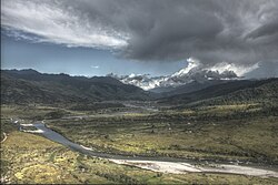
Shi Yomi district's Mechuka is gradually becoming a popular tourist destination in Arunachal Pradesh due to its scenic beauty, exotic tribes, gentle hills, snow-capped mountains, and Siom River. The Siyom River, which flows through Mechukha also provides a scenic view of the valley. [14]

The major tourist attraction here is the 400-year-old Samten Yongcha monastery located at Neh Pemashubu on a hilltop 13 km westernmost of Mechukha. Since this was the meditation place for the 6th rebirth of Guru Padmasambhāva of the Mahayana Buddhist sect, it is a pilgrimage place. This monastery is contemporary of the much-revered Tawang Monastery. It is locally also known as the gurudwara. [14] [15] It is reachable by helicopter service from Itanagar via Aalo or a train until the nearest railway station at Murkongselek 330 km away in Assam. [15]

See also

Related Research Articles

<span class="mw-page-title-main">Arunachal Pradesh</span> State in northeast India

Arunachal Pradesh is a state in northeast India. It was formed from the North-East Frontier Agency (NEFA) region, and India declared it as a state on 20 February 1987. It has been a subject of dispute between India and China since 1962. Itanagar is its capital and largest town. It borders the Indian states of Assam and Nagaland to the south. It shares international borders with Bhutan in the west, Myanmar in the east, and a disputed 1,129 km border with China's Tibet Autonomous Region in the north at the McMahon Line.

<span class="mw-page-title-main">Adi people</span> Ethnic group of Tibet and Northeast India

The Adi people are one of the most populous groups of indigenous peoples in the Indian state of Arunachal Pradesh. A few thousand are also found in the Tibet Autonomous Region, where they are called the Lhoba together with some of the Nyishi people, Na people, Mishmi people and Tagin people.

The Indian state of Arunachal Pradesh has a total population of roughly 1.4 million on an area of 84,000 km2, amounting to a population density of about 17 pop./km2. The "indigenous groups" account for about two thirds of population, while immigrants, mostly of Bengali/Hindi belt origin, account for the remaining third.

<span class="mw-page-title-main">Upper Subansiri district</span> District of Arunachal Pradesh in India

Upper Subansiri (Pron:/su:bənˈsɪɹi/) is an administrative district in the state of Arunachal Pradesh in India.

<span class="mw-page-title-main">West Siang district</span> District of Arunachal Pradesh in India

West Siang district is an administrative district in the state of Arunachal Pradesh in India.

Seppa is the headquarter of the East Kameng district in the state of Arunachal Pradesh in India. Sepla means 'marshy' land in the local dialect. It lies on the bank of Kameng River with a helipad located in the heart of the town. It is located 160 kilometres (99 mi) from Itanagar and 213 kilometres (132 mi) from Tezpur (Assam) connected by motorable road. The village of Seppa has two out of the sixty Vidhan Sabha Constituencies of Arunachal Pradesh. They are Seppa East and Seppa West.

Daporijo is a census town in the Upper Subansiri district, Indian state of Arunachal Pradesh in the Northeast of India.

<span class="mw-page-title-main">Aalo</span> District Headquarters in Arunachal Pradesh, India

Aalo, formerly Along, is a census town and headquarter of the West Siang district district of the Indian state of Arunachal Pradesh. It is located 137 kilometres (85 mi) from Likabali, which is at the border of Assam and Arunachal Pradesh.

Tani, is a branch of Sino-Tibetan languages spoken mostly in Arunachal Pradesh, Assam, and neighboring regions.

The Trans-Arunachal Highway (TAH), which includes an existing 1,811 km (1,125 mi) route comprising NH-13 and parts of NH-15, NH-215 and SH-25, is an under-construction 2-lane more than 2,407 km (1,496 mi) long highway passing through 16 districts in Arunachal Pradesh state in India. It runs from LAC in Tawang in northwest to Kanubari in southeast at tri-junction of Assam-Nagaland-Arunachal Pradesh. It connects at least 16 districts of Arunachal Pradesh.

<span class="mw-page-title-main">Mechuka</span> Town in Arunachal Pradesh, India

Mechukha or Menchukha is a town, assembly constituency and subdivision, situated 6,000 feet (1,829 m) above sea level in the Mechukha Valley of Yargep Chu/ Siyom River in Shi Yomi district of Arunachal Pradesh state of India. Before the 1950s, Mechuka valley was known as Pachakshiri.

Koloriang is a hilly district headquarters town of Kurung Kumey district in Arunachal Pradesh, India, bordering Tibet. It has an altitude of 1,000 metres (3,300 ft) and is surrounded by high mountains all around and is located in the right bank of river Kurung, one of the major tributaries of Subansiri river. The climate is rainy and hot during summer and very cold in winter. Located at an altitude of 1,040 metres above sea level, this town is also an old administrative centre. It is about 257 km from state capital, Itanagar.

Arunachal Frontier Highway (AFH), officially notified as the National Highway NH-913 and also called Bomdila-Vijaynagar Highway (BVH), connecting Bomdila Airstrip ALG & HQ in northwest to Vijaynagar Airstrip ALG & HQ in southeast via Nafra HQ-Sarli HQ-Huri Helipad ALG & HQ-Nacho HQ-Mechuka Airstrip ALG & HQ-Monigong HQ-Jido -Hunli HQ-Hayuliang Airstrip ALG HQ-Chenquenty-Hawai HQ-Miao HQ including 800 km greenfield section and network of new tunnels & bridges, is a 2-lane paved-shoulder under-construction national highway along the India-China LAC-McMahon Line border in the Indian state of Arunachal Pradesh. The 1,748 km-long (1,086 mi) highway itself will cost 27,000 crore and total cost including 6 additional inter-corridors is 40,000 crore. In some places, this highway will run as close as 20 km from the LAC. To be constructed by MoRTH in 9 packages, all packages will be approved by the end of fy 2024-25 and construction will be completed in 2 years by 31 March 2027. Of the total route, 800km is greenfield, rest brownfield will be upgraded and tunnels will be built. This highway in the north & east Arunachal along the China border, would complement the Trans-Arunachal Highway and the Arunachal East-West Corridor as major highways spanning the whole state, pursuing the Look East connectivity policy.

<span class="mw-page-title-main">Tuting</span> Town in Arunachal Pradesh, India

Tuting is a town and headquarters of an eponymous circle in the Upper Siang district in Arunachal Pradesh, India. It is situated on the bank of Siang river (Brahmaputra) at a distance of 34 km (21 mi) south of Line of Actual Control and 170 km (110 mi) north of Yingkiong. Tuting is the center of an assembly constituency, and also home to an Indian Military headquarters. The border area reports frequent incursion attempts by the Chinese People's Liberation Army, including an attempt to construct a road in Indian territory.

Taliha is a village in the Upper Subansiri district in Arunachal Pradesh state of India.

Nacho is a village in the Indian state of Arunachal Pradesh. Upper Subansiri is the name of the district that contains village Nacho.

Mechuka Advanced Landing Ground is an Indian Air Force airstrip located at Mechuka in Shi Yomi district of Arunachal Pradesh, India. It is an Advance Landing Ground (ALG) of Indian Air Force.

<span class="mw-page-title-main">Taksing</span> Village in Arunachal Pradesh, India

Taksing is a village and headquarters of an eponymous Circle in the Upper Subansiri district, Arunachal Pradesh, India. The region of Taksing is populated by Tagin people.

References

  1. "Arunachal Assembly Passes Bill For Creation Of 3 New Districts". NDTV.com. Retrieved 30 August 2018.
  2. "Arunachal Pradesh gets 25th district called Shi Yomi". www.telegraphindia.com. Retrieved 16 February 2019.
  3. Bureau, EastMojo News (10 December 2018). "Shi Yomi is the 23rd district of Arunachal Pradesh". EastMojo. Retrieved 19 October 2022.
  4. "The last village in our arunachal" . Retrieved 1 August 2017.
  5. District census 2011 - West Siang
  6. 2011 Census of India, Population By Mother Tongue
  7. "C-16 Population By Religion - Arunachal Pradesh". census.gov.in. Office of the Registrar General & Census Commissioner, India.
  8. "Assembly Constituencies allocation w.r.t District and Parliamentary Constituencies". Chief Electoral Officer, Arunachal Pradesh website. Retrieved 21 March 2011.
  9. "Mechuka MLA". Archived from the original on 19 August 2016. Retrieved 14 August 2016.
  10. Border Road Org builds strategic road in remote Arunachal near China, Business Standard, 4 Sept 2017.
  11. SARDP approved roads, SARDP plan, 2017.
  12. Defence committee: action taken report, Parliament of India, 12 Feb 2021.
  13. 1 2 3 Arunachal Pradesh plans fixed-wing flight service to Mechuka, closest to China border, The Hindu, 15 May 2018.
  14. 1 2 "Mechuka Valley to be next tourist hotspot in northeast". The Times of India . 20 April 2012. Archived from the original on 4 July 2013. Retrieved 26 April 2013.
  15. 1 2 Neh-pemashubu Monasty, Shi Yomi district website, NIC.