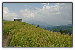
Miao is a sub-division in the Changlang district in the state of Arunachal Pradesh, India. It is located about 25 km from the Assam border. It is one of the 60 constituencies of Arunachal.

Arunachal Pradesh is a state in northeast India. It was formed from the North-East Frontier Agency (NEFA) region, and India declared it as a state on 20 February 1987. Itanagar is its capital and largest town. It borders the Indian states of Assam and Nagaland to the south. It shares international borders with Bhutan in the west, Myanmar in the east, and a disputed 1,129 km border with China's Tibet Autonomous Region in the north at the McMahon Line. Arunachal Pradesh is claimed in its entirety by China as South Tibet as part of the Tibet Autonomous Region; China occupied some regions of Arunachal Pradesh in 1962 but later withdrew its forces.

Ziro is a town in and the district headquarters of the Lower Subansiri district in the Indian state of Arunachal Pradesh. It is included the Tentative List for UNESCO's World Heritage Site for the Apatani cultural landscape. The part of the town which is the centre of economic activities and where the administrative offices are located is called Hapoli, or locally known by the Apatanis as "Hao-Polyang".
The Indian state of Arunachal Pradesh has a total population of roughly 1.4 million on an area of 84,000 km2, amounting to a population density of about 17 pop./km2. The "indigenous groups" account for about two thirds of population, while immigrants, mostly of Bengali/Hindi belt origin, account for the remaining third.

Changlang district (Pron:/tʃæŋˈlæŋ/) is located in the Indian state of Arunachal Pradesh, located south of Lohit district and north of Tirap district. Naga people reside here. As of 2011 it is the second most populous district of Arunachal Pradesh, after Papum Pare. It has become one of the major districts in the area owing to the presence of crude oil, coal and mineral resources in addition to tourism and hydropower.

The Tangshang people or Tangsa , are of Tibeto-Burmese ethnic group of the Arunachal Pradesh and Assam. They also reside in Sagaing Region and parts of Kachin State of Myanmar. In Myanmar they were formerly known as Rangpang, Pangmi, and Haimi. They speak their own language Tangsa.
Tirap district (Pron:/tɪˈɹæp/) is a district located in the southeastern part of the state of Arunachal Pradesh in India. It shares a state border with Assam, an international border with Myanmar and a district border with Changlang and Longding.

Lohit is an administrative district in the state of Arunachal Pradesh in India. The district headquarters is located at Tezu. As of 2011 it is the third most populous district of Arunachal Pradesh, after Papum Pare and Changlang.
Daporijo is a census town in the Upper Subansiri district, Indian state of Arunachal Pradesh in the Northeast of India.

Pangsau Pass or Pan Saung Pass, 3,727 feet (1,136 m) in altitude, lies on the crest of the Patkai Hills on the India–Myanmar border. The pass offers one of the easiest routes into Burma from the Assam plains. The pass lies on the famous Ledo Road and named after the closest village on Myanmar's territory, Pangsau, which lies 2 km east of the pass. India's undisputed easternmost point "Chaukan Pass" - east of Vijaynagar in the Changlang district - lies northeast of Pangsau Pass.
Changlang is a census town and headquarters of the Changlang district in the Indian state of Arunachal Pradesh. It has become one of the major districts in the area owing to the presence of crude oil, coal and mineral resources other than tourism and hydro power.
Bargolai is a village located in Margherita, a sub-district of Tinsukia District in the state of Assam, India.
The Tutsa people, also known as the Tutsa , are a Tibeto-Burmese ethnic group inhabiting the western parts of Changlang and Khimiyong circles and the eastern part of Tirap districts of the Northeast Indian state of Arunachal Pradesh. Ethnically, the Tutsa are closely related to the Tangsa and were classified as members of the Tangsa in all census records until 1981. As of 2001 their population stood at 25,000.

Hawai is the district headquarters of Anjaw District in the state of Arunachal Pradesh in north-east India.

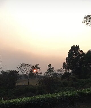
Margherita is a census town in Tinsukia district in the Indian state of Assam. The sub-district town is surrounded by hills, tea gardens, forests and the Dihing River. It has a golf course at the foot of the hills and a small stream running through. Although considered to be a small town, Margherita has several hospitals and educational institutions and is regularly frequented by visitors on account of it being the last proper town of Upper Assam. The name Margherita actually derives from the Italian queen and dates back to the late 19th century as a token appreciation for the Italian Chief Engineer of a rail section Chevalier R Paganini who supervised the construction. Margherita was known for its collieries much developed by the British. Coal India Ltd has the biggest industrial plant here. The town is also known as Coal Queen as it is famous for coal business. Apart from this there are other industrial plants like Kitply and Tata Tea, along with minor plywood industries and tea gardens. Margherita has Tea Estates of the Williamson Magor Group. Namdang Tea Estate, Dirok Tea Estate, Dehing Tea Estate, Bogapani Tea Estate and Margherita Tea Estate are the 5 famous estates of the McLeod Russel India Limited Group situated at the sub division Margherita. McLeod Russel India Limited is one of the largest tea producers in Asia.
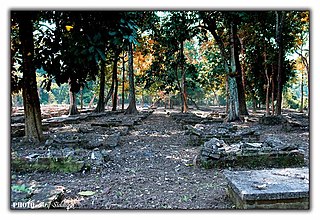
Jairampur cemetery is a World War II cemetery in Arunachal Pradesh, India. It is located 7 km from Jairampur, Changlang district, and 25 km from Pangsau Pass, the Indo-Myanmar Border on the road to Ledo. It was discovered in 1997.
Kharsang is a small town located in the Changlang district of Arunachal Pradesh, India. It serves as an administrative sub-division of the district.

Tangsa, also known as Tase and Tase Naga, is a Sino-Tibetan language or language cluster spoken by the Tangsa people of Burma and north-eastern India. Some varieties, such as Shangge (Shanke), are likely distinct languages. There are about 60,000 speakers in Burma and 40,000 speakers in India. The dialects of Tangsa have disparate levels of lexical similarity, ranging from 35%–97%.
Nampong is a census town of Changlang District in the Indian state of Arunachal Pradesh. It is located close to the Pangsau Pass, being the last town on the Indian side, at an elevation of 308 metres. Nampong is one of the 60 constituencies of Arunachal. Name of current MLA (August-2016) of Nampong constituency is Laisam Simai.