Gomsi

Last updated

Gomsi
Gomsi.jpg
Location Rani Village, East Siang District, Arunachal Pradesh, India
RegionFlag of India.svg  India
Coordinates 28°04′N95°20′E / 28.07°N 95.33°E / 28.07; 95.33
TypeSettlement
History
Builderexpected as Chutia King
Founded13th-14th century
Site notes
ConditionRuined
OwnershipPublic
Management Archaeological Survey of India
Public accessYes
It is now undertaken by the Govt. of India

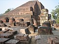
Gomsi is an ancient archaeological site located between Rani Village and Sika Tode [1] in East Siang District, Arunachal Pradesh, India. It is dated to the 13th-14th century by the Directorate of Research, Government of Arunachal Pradesh [2] and is associated with the Chutia Kingdom. It is located at the field of Rani Village, about 15 km from the town of Pasighat.

Contents

It might have acted as a checkpoint of the Chutia kingdom to keep peace in the region as well to control the trade exchanges at that period. There is also an ancient man-made pond(pukhuri) built as a part of the settlement.

Excavation at Gomsi

Report of 1995-96

The Directorate of Research, Government of Arunachal Pradesh, conducted trial-excavation at the main mound and at extreme northwestern corner of the site which comprised 5 acres of land. The site is located at 15 km in the southwestern direction from the district headquarters, Pasighat and 19 km inside from Murkong Salak, nearest Railwayhead in Assam-Arunachal border.

A portion of brick-wall was exposed out of a house structure. Excavation of almost rectangular mound (21x17 m), revealed ten brick courses to the northwestern corner of the wall showing both the base and the floor levels. Above the floor level, a superstructure was raised by using some perishable material.

In all, there were thirteen different sizes and shapes of bricks, used for construction. The excavation also revealed different types of pottery along with a few pieces of stone urn. Black painted pottery, with criss-cross design and a piece of flower vase were recovered from the digging in addition to an iron spear-head, besides one spear-head made of iron from 15 cm below surface level.

From the preliminary study of the findings, the site could be assignable to the Chutia period(pre-Ahom period).

Report of 1996-97

The site is spread in an area of 11.5 acres of land. Excavation revealed that the site represents a large brick mound with L-shaped large earthen mound measuring (23 m x 23 m x 24 m) about 3 m south of it and a rectangular pond measuring 38 m x 28 m about 60 m south of the mound. These are surrounded by nala measuring 3.5 m wide from all corners and both ends meeting in the pond. The nala served a dual purpose of a moat and a source of water supply. A number of small earthen mounds measuring about 14 m x 10 m are also situated in the vicinity at regular intervals.

Related Research Articles

<span class="mw-page-title-main">Arunachal Pradesh</span> State in northeast India

Arunachal Pradesh is a state in northeast India. It was formed from the North-East Frontier Agency (NEFA) region, and India declared it as a state on 20 February 1987. Itanagar is its capital and largest town. It borders the Indian states of Assam and Nagaland to the south. It shares international borders with Bhutan in the west, Myanmar in the east, and a disputed 1,129 km border with China's Tibet Autonomous Region in the north at the McMahon Line. It is disputed by China and claimed as part of Tibet. China occupied some regions of Arunachal Pradesh in 1962 but later withdrew its forces.

<span class="mw-page-title-main">Pinson Mounds</span> Archaeological park

The Pinson Mounds comprise a prehistoric Native American complex located in Madison County, Tennessee, in the region that is known as the Eastern Woodlands. The complex, which includes 17 mounds, an earthen geometric enclosure, and numerous habitation areas, was most likely built during the Middle Woodland period. The complex is the largest group of Middle Woodland mounds in the United States. Sauls' Mound, at 72 feet (22 m), is the second-highest surviving mound in the United States.

<span class="mw-page-title-main">Angel Mounds</span> United States historic place

Angel Mounds State Historic Site, an expression of the Mississippian culture, is an archaeological site managed by the Indiana State Museum and Historic Sites that includes more than 600 acres of land about 8 miles (13 km) southeast of present-day Evansville, in Vanderburgh and Warrick counties in Indiana. The large residential and agricultural community was constructed and inhabited from AD 1100 to AD 1450, and served as the political, cultural, and economic center of the Angel chiefdom. It extended within 120 miles (190 km) of the Ohio River valley to the Green River in present-day Kentucky. The town had as many as 1,000 inhabitants inside the walls at its peak, and included a complex of thirteen earthen mounds, hundreds of home sites, a palisade (stockade), and other structures.

<span class="mw-page-title-main">Pasighat</span> Town in Arunachal Pradesh, India

Pasighat is the headquarters of East Siang district in the Indian state of Arunachal Pradesh. Situated at the eastern foothills of the Himalayas at 155 meters (509 ft) above mean sea level, Pasighat is Arunachal's oldest town. The Government of India included Pasighat in the Smart Cities Mission development scheme in June 2017.

<span class="mw-page-title-main">Mahasthangarh</span> Archaeological site of Bangladesh

Mahasthangarh is one of the earliest urban archaeological sites discovered thus far in Bangladesh. The village Mahasthan in Shibganj upazila of Bogra District contains the remains of an ancient city which was called Pundranagara or Paundravardhanapura in the territory of Pundravardhana. A limestone slab bearing six lines in Prakrit in Brahmi script recording a land grant, discovered in 1931, dates Mahasthangarh to at least the 3rd century BCE. It was an important city under the Maurya Empire. The fortified area was in use until the 8th century CE.

Sadiya is a town in Tinsukia district, Assam. It was the capital of the Chutia Kingdom and after the downfall of the kingdom it became the seat of the Sadiya-khowa-Gohain of the Ahom kingdom. Extensive remains of buildings and fortifications built during the rule of the Chutias near Sadiya still point to the importance of the region in the past. Historically Sadiya referred to the Chutiya kingdom which included at times the districts of Lakhimpur, Dhemaji and Tinsukia. It is claimed to be the center of development of the eastern Assamese dialects, the inscription here are written in a Tai script. Its stands on a grassy plain, almost surrounded by forested Himalayan mountains, on the right bank of Lohit River which is locally considered the main stream of the Brahmaputra River. The deepest point of the Brahmaputra River is located near this village. It is famous for a flower named satphul, which is much like Jasmine.

<span class="mw-page-title-main">Lauria Nandangarh</span> City/town in Bihar, India

Lauria Nandangarh, also Lauriya Navandgarh, is a city or town about 14 km from Narkatiaganj and 28 km from Bettiah in West Champaran district of Bihar state in northern India. It is situated near the banks of the Burhi Gandak River. The village draws its name from a pillar (laur) of Ashoka standing there and the stupa mound Nandangarh about 2 km south-west of the pillar. Lauriya Nandangarh is a historical site located in West Champaran district of Bihar. Remains of Mauryan period have been found here.

Banawali is an archaeological site belonging to Indus Valley civilization period in Fatehabad district, Haryana, India and is located about 120 km northeast of Kalibangan and 16 km from Fatehabad. Banawali, which is earlier called Vanavali, is on the left banks of dried up Sarasvati River. Comparing to Kalibangan, which was a town established in lower middle valley of dried up Sarasvathi River, Banawali was built over upper middle valley of Sarasvati River.

<span class="mw-page-title-main">Barabati fort</span> Fort in Cuttack

Barabati Fort is a 987 CE fort built by Marakata Keshari of Somavanshi (Keshari) dynasty in Cuttack, Odisha. The ruins of the fort remain with its moat, gate, and the earthen mound of the nine-storied palace.

<span class="mw-page-title-main">Tumulus of Bougon</span> Tumulus in Bougon, France

The Tumulus of Bougon or Necropolis of Bougon is a group of five Neolithic barrows located in Bougon, near La-Mothe-Saint-Héray, between Exoudon and Pamproux in Nouvelle-Aquitaine, France.

<span class="mw-page-title-main">Jagjivanpur</span>

Jagajjibanpur or Jagajivanpur is an archaeological site in Habibpur block of Malda district in West Bengal state in eastern India. This site is located at a distance of 41 km east from English Bazar town. The most significant findings from this site include a copper-plate inscription of Pala emperor Mahendrapaladeva and the structural remains of a 9th-century Buddhist Vihara: Nandadirghika-Udranga Mahavihara.

Gilund is a village and an archaeological site located in Rajsamand district of Rajasthan state in western India. It is one of five ancient sites excavated in the Ahar-Banas Complex which also includes the sites of Ahar, Ojiyana, Marmi, and Balathal. Out of the 111 reported sites found in the Ahar-Banas Complex, Gilund is the largest. The archaeological site was named after the present-day village, Gilund, and is locally known as Modiya Magari which means "bald habitation mound".

<span class="mw-page-title-main">Poverty Point</span> Prehistoric site of the Poverty Point culture in northeastern Louisiana, United States

Poverty Point State Historic Site/Poverty Point National Monument is a prehistoric earthwork constructed by the Poverty Point culture, located in present-day northeastern Louisiana. Evidence of the Poverty Point culture extends throughout much of the Southeastern Woodlands of the Southern United States. The culture extended 100 miles (160 km) across the Mississippi Delta and south to the Gulf Coast.

Mitathal is a village and Indus Valley civilization (IVC) Archaeological sites in the Bhiwani tehsil of the Bhiwani district in the Indian state of Haryana. Part of Hisar division, it lies 12 kilometres (7.5 mi) north of the district headquarters Bhiwani and 249 kilometres (155 mi) from the state capital Chandigarh. As of the 2011 Census of India, the village had 1,448 households with a total population of 7,434 of which 4,002 were male and 3,432 female.

Rani Village or Rani is a small village located in the Sille-Oyan circle of East Siang district, Arunachal Pradesh with a total of 924 residing families. It is situated 12 km from the district headquarter Pasighat and the 3rd largest village in the East Siang district, after Riga Village and Mirem Village.

<span class="mw-page-title-main">Malinithan</span> Archaeological site in Arunachal Pradesh, India

Malinithan is an archaeological site containing the ruins of an early medieval period temple on the northern bank of the Brahmaputra River in the Indian state of Arunachal Pradesh. It is assumed to be built by the Chutia kings in the 13th-14th century. Kechai-Khaiti, a tribal goddess found among the Bodo-kachari groups or the Buddhist goddess Tara is considered to be the chief deity worshipped in the ruined temple. The worship of the goddess Kechaikheiti even after coming under Hindu influence was performed according to her old tribal customs.

Boleng is a town in Siang district, lying on the banks of Siang River in the Indian state of Arunachal Pradesh. It is the headquarters of the newly created Siang District, which was bifurcated from West Siang and East Siang. It is located about 100 km from Pasighat, East Siang district of Arunachal Pradesh. The district is named after the Brahmaputra, locally known as Siang.

<span class="mw-page-title-main">Bhismaknagar</span>

Bhismaknagar is an archeological site in Indian state of Arunachal Pradesh. It is located near Roing in Lower Dibang Valley district. The remains are generally ascribed to the rule of the Sutiyas, a Bodo-Kachari (Tibeto-Burmese) ethnic group who ruled over the region of Sadiya from 11th to 16th Century CE.

<span class="mw-page-title-main">Bestansur</span> Neolithic site in Iraq

Bestansur is a Neolithic tell, or archaeological settlement mound, located in Sulaimaniyah province, Kurdistan Regional Government, Iraq in the western Zagros foothills. The site is located on the edge of the Shahrizor Plain, 30 km to the south-east of Sulaimaniyah. It is on the UNESCO World Heritage Tentative List.

<span class="mw-page-title-main">Rajpat</span> Archaeological site in West Bengal, India

Rajpat or Kamtapur Fort is an archaeological site in present-day Gosanimari in the Dinhata I CD block in the Dinhata subdivision of the Cooch Behar district in West Bengal, India.

References

  1. Gomsi (Rani), East Siang, Remains of old settlement,13th to 14th century A.D.

Commons-logo.svg Media related to Gomsi at Wikimedia Commons

Geographical location