
Visakhapatnam, also known as Vizag, Viśākha or Waltair, is the largest and most populous metropolitan city in the Indian state of Andhra Pradesh. It is between the Eastern Ghats and the coast of the Bay of Bengal. It is the second largest city on the east coast of India after Chennai, and the fourth-largest in South India. It is one of the four smart cities of Andhra Pradesh selected under the Smart Cities Mission and is the headquarters of Visakhapatnam district. With an estimated output of $43.5 billion, it is the ninth-largest contributor to India's gross domestic product as of 2016.

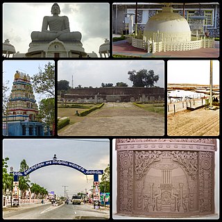
Srikakulam is a city and the headquarters of Srikakulam district in the Indian state of Andhra Pradesh. As of 2011 census, it has a population of 165,735. There are many other places of Buddhist Tourism such as Salihundam, Kalinga Patnam, Dabbaka Vaani Peta, Nagari Peta, Jagati Metta, Singupuram etc. in Srikakulam District. The Buddhist heritage site of Salihundam has some unique features. It has a beautiful star atop a stupa, rock cut massive stupas inside chaitya grihas, brick stupas with wheel pattern plan, votive stupas, inscriptions on the steps leading to the stupas and museum housing over two dozen sculpted statue and figurines of Buddha, Jain Teerthankars and other deities

Coastal Andhra or Kosta Andhra is a geographic region in the Indian state of Andhra Pradesh. Vijayawada is the largest city in this region. Region share borders with Uttarandhra, Rayalaseema and Telangana. It was part of Madras State before 1953 and Andhra State from 1953 to 1956. According to the 2011 census, it has an area of 91,915 square kilometres (35,489 sq mi) which is 57.99% of the total state area and a population of 34,193,868 which is 69.20% of Andhra Pradesh state population. This area includes the coastal districts of Andhra Pradesh on the Circar Coast between the Eastern Ghats and the Bay of Bengal, from the northern border with Odisha to Rayalaseema in the south.
Amaravathi is a village on the banks of the Krishna River, in the Palnadu district of the Indian state of Andhra Pradesh. It is the headquarters of Amaravathi mandal, and forms part of the Andhra Pradesh Capital Region with its headquarters at new Amaravati 35 km (22 mi) east, whose name is also borrowed from that of the older Amaravathi.

Srikakulam district is one of the twenty-six districts of the Indian state of Andhra Pradesh, located in the Uttarandhra region of the state, with its headquarters located at Srikakulam. It is one of the six districts, located in the extreme northeastern direction of the state. It was formerly known as Chicacole, and was under Ganjam district till 1936 April 1, then merged under Vizagapatam district. Srikakulam district forms the core area of Kalinga where most of its historical capitals like Kalinganagari, pithunda, Dantapuram are located.

Bhattiprolu is a village in Bapatla district of the Indian state of Andhra Pradesh. It is the headquarters of Bhattiprolu mandal in Tenali revenue division. The Buddhist stupa in the village is one of the centrally protected monuments of national importance. One of the earliest evidence of Brahmi script in South India comes from Bhattiprolu. The script was written on an urn containing Buddha's relics. The script has been named Bhattiprolu script.
Amadalavalasa is a town in Srikakulam district of the Indian state of Andhra Pradesh. It is a municipality and also the mandal headquarters of Amadalavalasa mandal. The town is spread over an area of 19.65 km2 (7.59 sq mi), which is under the jurisdiction of Visakhapatnam Metropolitan Region Development Authority. Srikakulam Road railway station is situated at Amadalavalasa.

Tuni is a City in Kakinada district of the Indian state of Andhra Pradesh. It is a second biggest city in Kakinada district. Freedom fighter Alluri Sitaramaraju studied here. It is a major commercial marketing centre for more than 200+ surrounding villages in the district. Tuni is a border point for the district of Kakinada. It is known for mango production, with nearly 250 varieties being exported from the area. Tuni City is also known as "Mango City". Tuni is also famous for the production of betel leaves and jute bags. A variety of cashew nuts are also produced in Tuni.

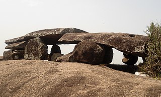
Nagarjunakonda: Nāgārjunikoṇḍa, meaning Nagarjuna Hill) is a historical town, now an island located near Nagarjuna Sagar in Palnadu district of the Indian state of Andhra Pradesh. It is one of India's richest Buddhist sites, and now lies almost entirely under the lake created by the Nagarjuna Sagar Dam. With the construction of the dam, the archaeological relics at Nagarjunakonda were submerged, and had to be excavated and transferred to higher land, which has become an island.

Kalingapatnam is a village in Srikakulam district of the Indian state of Andhra Pradesh. It is located in Gara mandal of Srikakulam revenue division. It has one of the major beach sand deposits of the state. In medieval era it was famous for the ancient port city of Kalinga. Kalingapatnam is located at a distance of 26 km from the district headquarters and 17 km from Singupuram.
Mukhalingam, also known as Srimukhalingam or Mukhalinga, is a village panchayat in Jalumuru mandal of Srikakulam district in the Indian state of Andhra Pradesh. Historically known as Kalinganagari, Mukhalingam served as the capital of Eastern Ganga Dynasty from 6th century AD to 12th century AD. Emperor Sri Ananthavarma Chodaganga Devara conquered Utkala in 1122 AD and shifted the capital from Kalinganagari to Caudwara kataka
In religion and spirituality, a pilgrimage is a long journey or search of great moral significance. Sometimes, it is a journey to a sacred place or to a shrine of importance to a person's beliefs and faith. Members of every major religion participate in pilgrimages. A person who makes such a journey is called a pilgrim.

Pushpagiri was an ancient Indian mahavihara or monastic complex located atop Langudi Hill in Jajpur district of Odisha, India. Pushpagiri was mentioned in the writings of the Chinese traveller Xuanzang and some other ancient sources. Until the 1990s, it was hypothesised to be one or all of the Lalitgiri-Ratnagiri-Udayagiri group of monastic sites, also located in Jajpur district. These sites contain ruins of many buildings, stupas of various sizes, sculptures, and other artifacts.

Andhra Pradesh is a state in India. Andhra Pradesh Tourism Development Corporation (APTDC) is a state government agency which promotes tourism in Andhra Pradesh, describing the state as the Koh-i-Noor of India. Andhra Pradesh has a variety of tourist attractions including beaches, hills, caves, wildlife, forests and temples.

Danthapuri is one of the historical place near Amadalavalasa. It is a village situated on the way from Amadalavalasa to Hiramandalam in Andhra Pradesh, India. It is 10 km (6.2 mi) from Amadalavalasa and 22 km (14 mi) away from Srikakulam Town.

Nelakondapally, also referred to as Nelakondapalli or Nela Kondapalli, is a town and headquarters of a mandal in Khammam district, Telangana, India. It is also an archaeological site important to early Buddhism and Hinduism, where excavations have discovered a major stupa site near an ancient manmade lake, another site where Buddhist and Hindu artwork were carved in pre-3rd century India, both sites also yielding hundreds of ancient rare coins with Shaiva and Vaishnava inscriptions from the dynasties of Andhra Ikshvakus and Vishnukundinas. Nelakondapally is also the birthplace of Bhakta Ramadasu.
Veluri Venkata Krishna Sastry was an archaeologist and historian in Andhra Pradesh, India.
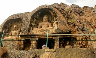
Bojjannakonda and Lingalakonda are two Buddhism rock-cut caves on adjacent hillocks, situated near a village called Sankaram, Anakapalle of ancient Kalinga. in the Indian state of Andhra Pradesh. The sites are believed to date between 4th and 9th Century A.D, when Buddhism is the majority religion of Sankaram. The original name of Bojjannakonda is Buddina Konda.

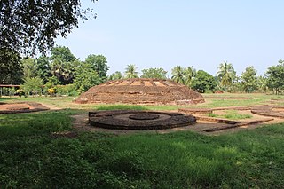
Chandavaram Buddhist site is an ancient Indian Buddhist site in Chandavaram village in Prakasam district in the Indian state of Andhra Pradesh. Situated on the bank of Gundlakamma River, the site is 10 kilometres (6.2 mi) northwest of Donakonda railway station. The Chandavaram Buddhist site was built between the 2nd century BCE and the 2nd century CE during the Satavahana dynasty and was discovered by Veluri Venkata Krishna Sastry in 1964.
Adurru is a village and a 2nd-century CE Buddhist archaeological site in the Dr. B.R. Ambedkar Konaseema district of Andhra Pradesh, India. It is located in the Mamidikuduru Mandal, on the western bank of Vainateya, a distributary of the Godavari river, around 9.5 km from the Bay of Bengal.


