Coastal Andhra, is a region in the state of Andhra Pradesh, India. This region was part of Madras State before 1953 and Andhra State from 1953 to 1956. According to the 2011 census, it has an area of 95,442 square kilometres (36,850 sq mi) which is 57.99% of the total state area and a population of 34,193,868 which is 69.20% of Andhra Pradesh state population. This area includes the coastal districts of Andhra Pradesh on the Coromandel Coast between the Eastern Ghats and the Bay of Bengal, from the northern border with Odisha to Pulicat lake of South.

Ghantasala is a village in Krishna district of the Indian state of Andhra Pradesh. It is 21 km west of Machilipatnam and 11 km east of Krishna River. The largest city of this district, Vijaywada, is around 60 km away. It is a rare and reputed center for Buddhist sculptures.

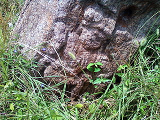
Ramateertham is a village panchayat in Nellimarla mandal of Vizianagaram district in Andhra Pradesh in India.It is about 12 km from Vizianagaram city. It is a famous Pilgrimage and also Ancient Historical Site since 3rd Century BCE There is a post office at Ramateertham. The PIN code is 535 218.

Anakapalle is a suburb of Visakhapatnam in the Indian state of Andhra Pradesh. The municipality was merged with Greater Visakhapatnam Municipal Corporation. It has the second largest jaggery market of the country.
Amadalavalasa is a town in Srikakulam district of the Indian state of Andhra Pradesh. It is a municipality and also the mandal headquarters of Amadalavalasa mandal. The town is spread over an area of 19.65 km2 (7.59 sq mi), which is under the jurisdiction of Visakhapatnam Metropolitan Region Development Authority. Srikakulam Road railway station is situated at Amadalavalasa.

Tuni is a town in East Godavari district of the Indian state of Andhra Pradesh. It is a major commercial marketing center for more than 40 surrounding villages in the district. Tuni is a border point for the district of East Godavari. It is known for mango export, with nearly 250 varieties. It is also famous for betel leaves and jute bags. A variety of cashew nuts are produced in Tuni.

Gosthani River is an east flowing river in Andhra Pradesh, India that flows from the Ananthagiri Hills of the Eastern Ghats into the Bay of Bengal.

Pushpagiri was an ancient Buddhist mahavihara located atop Langudi Hills in Jajpur district of Odisha, India. The complex contains ruins of stupas, rock-cut sculptures and other artifacts.
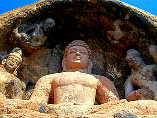
Bojjannakonda and Lingalakonda are two Buddhist rock-cut caves on adjacent hillocks, situated near a village called Sankaram, which is a few kilometres away from Anakapalle, Vishakhapatnam in the Indian state of Andhra Pradesh. The sites are believed to date between 4th and 9th Century A.D, when the 3 phases of Buddhism flourished at Sankaram.

Keesaragutta Temple is a Hindu temple dedicated to Lord Siva and his consorts Bhavani and Sivadurga at Keesaragutta in Medchal-Malkajgiri district. It is about 30 km from Hyderabad and 12 km from ECIL. It is located on a small hillock. The temple draws up to lakhs of devotees on Shivaratri and karthika masam.

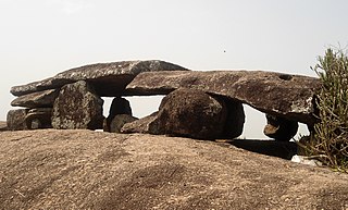
Kotturu Dhanadibbalu & Pandavula Guha is an ancient Buddhist site near Kotturu village of Rambilli mandal Visakhapatnam District of Andhra Pradesh. A post office is located at Kotturu Village with Pincode 531061
Neelavathi is a village and panchayat in Gantyada mandal of Vizianagaram district, Andhra Pradesh, India. The Postal Pincode of Neelavathi village is 535215

Thagarapuvalasa or Tagarapuvalsa is a village on the banks of River Gosthani is a part of Bheemunipatnam Municipality in Andhra Pradesh. It is located on the Kolkata–Chennai National Highway 5.
National Highway 43 diverts from Maharajupeta village north of Thagarapuvalasa.

The Guntupalle or Guntupalli Group of Buddhist Monuments is located near Kamavarapukota, West Godavari district, in the state of Andhra Pradesh in India. It is around 40 km away from Eluru. The rock-cut part of the site has two Buddhist caves, a chaitya hall and a large group of stupas. The chaitya hall has a rare carved stone entrance replicating wooden architecture, a simpler version of that at the Lomas Rishi Cave.
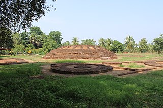
Chandavaram Buddhist site is an ancient Buddhist site in Chandavaram village in Prakasam district in the Indian state of Andhra Pradesh. Situated on the bank of Gundlakamma River, the site is 10 kilometres (6.2 mi) northwest of Donakonda railway station. The Chandavaram Buddhist site was built between the 2nd century BCE and the 2nd century CE during the Satavahana dynasty and was discovered by Dr. Veluri Venkata Krishna Sastry in 1964.
Adurru is a village and a Buddhist archaeological site in the East Godavari district of Andhra Pradesh, India. It is located in the Mamidikuduru mandal, on the western bank of Vainateya, a distributary of the Godavari river, around 9.5 km from the Bay of Bengal.