This article's tone or style may not reflect the encyclopedic tone used on Wikipedia.(August 2022) |
Pavurallakonda Pavurallabodu | |
---|---|
Protected Buddhist Monument | |
Coordinates: 17°53′19″N83°26′14″E / 17.88861°N 83.43722°E | |
Country | India |
State | Andhra Pradesh |
District | Visakhapatnam |
Languages | |
• Official | Telugu |
Time zone | UTC+5:30 (IST) |
Nearest city | Visakhapatnam |
Pavurallakonda or Pavurallabodu is a hill popularly known as Narasimhaswamy Konda. It is located near Bheemunipatnam, about 25km north of Visakhapatnam, in the Indian state of Andhra Pradesh, at a height of about 150 meters above sea level.
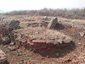
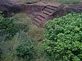
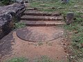
Pavurallakonda consists of a ruined hilltop Buddhist monastic complex that witnessed human habitation anywhere from the 3rd century BCE to the 2nd century CE. It is one of the largest Buddhist monasteries in the North Coastal Andhra Region. Hinayana Buddhism may have been practiced at this hilltop site.[ citation needed ]
The initial excavation of this site yielded many relics. [1] Among the ruins are two Brahmi label inscriptions, foundations of Viharas, circular chaityas, votive stupas, and halls. Coins, polished ware, [2] beads, and other artifacts were recovered from the site by the state archaeology department [3] of Andhra Pradesh. Nearly sixteen rock-cut cisterns were carved on the hill for the storage of rainwater. Excavations and restoration programs are ongoing at Pavurallakonda.[ citation needed ]
The Gosthani River flows close by this site. This site is contemporary with the nearby Buddhist sites in Visakhapatnam district, like Bavikonda and Thotlakonda. [4]
The Indian National Trust for Arts and Cultural Heritage (INTACH) has appealed to the authorities to ensure better protection of Buddhist sites after Bavikonda, Thotlakonda, Pavurallakonda, and Bojjannakonda were designated as heritage sites by UNESCO. [5] [6] This will not only pave the way for a steady flow of funds but also generate employment opportunities for the locals.[ citation needed ]
Pavurallakonda, in general, gives the meaning as 'The Hill of the Pigeons' (pavuralu in Telugu means pigeons and konda means hill). However, some studies conducted at this site suggest that it may be known as Pavurallakonda due to the availability of white stones on the hillock (pavurallu means "white stones" locally). The origin of the name of this site needs clarification.[ citation needed ]
Visakhapatnam is the largest and most populous metropolitan city in the Indian state of Andhra Pradesh. It is between the Eastern Ghats and the coast of the Bay of Bengal. It is the second largest city on the east coast of India after Chennai, and the fourth largest in South India. It is one of the four smart cities of Andhra Pradesh selected under the Smart Cities Mission and is the headquarters of Visakhapatnam district. With an estimated output of $43.5 billion, it is the ninth largest contributor to India's gross domestic product as of 2016.
Coastal Andhra or Kosta Andhra is a geographic region in the Indian state of Andhra Pradesh. Vijayawada is the largest city in this region. The region share borders with Rayalaseema, Uttarandhra and Telangana. It was a part of Madras State before 1953 and Andhra State from 1953 to 1956. According to the 2011 census, it has an area of 91,915 square kilometres (35,489 sq mi) which is 57.99% of the total state area and a population of 34,193,868 which is 69.20% of Andhra Pradesh state population. This area includes the coastal districts of Andhra Pradesh on the Circar Coast between the Eastern Ghats and the Bay of Bengal, from the northern border with Odisha to Rayalaseema in the south.
Ramateertham is a village panchayat in Nellimarla mandal of Vizianagaram district in Andhra Pradesh in India. It is about 12 km from Vizianagaram city. It is a famous Pilgrimage and also Ancient Historical Site since 3rd Century BCE. There is a post office at Ramateertham. The PIN code is 535218.
Amadalavalasa is a town in Srikakulam district of the Indian state of Andhra Pradesh. It is a municipality and also the mandal headquarters of Amadalavalasa mandal. The town is spread over an area of 19.65 km2 (7.59 sq mi), which is under the jurisdiction of Visakhapatnam Metropolitan Region Development Authority. Srikakulam Road railway station is situated at Amadalavalasa.
(MP = Sri Bharat Bheemunipatnam, is a suburb of Visakhapatnam, India. The town was named after Bhima, a character in the Hindu epic Mahabharata. It formerly administered under the Bheemunipatnam municipality, but merged into GVMC in 2017. It is currently under the administration of Bheemunipatnam revenue division and the headquarters is located at Bheemunipatnam.
Nagarjunakonda: Nāgārjunikoṇḍa, meaning Nagarjuna Hill) is a historical town, now an island located near Nagarjuna Sagar in Palnadu district of the Indian state of Andhra Pradesh. It is one of India's richest Buddhist sites, and now lies almost entirely under the lake created by the Nagarjuna Sagar Dam. With the construction of the dam, the archaeological relics at Nagarjunakonda were submerged, and had to be excavated and transferred to higher land, which has become an island.
Indian rock-cut architecture is more various and found in greater abundance in that country than any other form of rock-cut architecture around the world. Rock-cut architecture is the practice of creating a structure by carving it out of solid natural rock. Rock that is not part of the structure is removed until the only rock left makes up the architectural elements of the excavated interior. Indian rock-cut architecture is mostly religious in nature.
Salihundam, is a village and panchayat in Gara Mandal of Srikakulam district in Andhra Pradesh. It is a historically important Buddhist monument of ancient Kalinga and a major tourist attraction It is a village lying on top of the hill on the south bank of the Vamsadhara River. It is at a distance of 5 KM west to Kalingapatnam and 10 KM from Singupuram and 18 KM from Srikakulam town. It was known as Salipetaka.
In religion and spirituality, a pilgrimage is a long journey or search of great moral significance. Sometimes, it is a journey to a sacred place or to a shrine of importance to a person's beliefs and faith. Members of every major religion participate in pilgrimages. A person who makes such a journey is called a pilgrim.
Pushpagiri was an ancient Indian mahavihara or monastic complex located atop Langudi Hill in Jajpur district of Odisha, India. Pushpagiri was mentioned in the writings of the Chinese traveller Xuanzang and some other ancient sources. Until the 1990s, it was hypothesised to be one or all of the Lalitgiri-Ratnagiri-Udayagiri group of monastic sites, also located in Jajpur district. These sites contain ruins of many buildings, stupas of various sizes, sculptures, and other artifacts.
Andhra Pradesh is a state in India. Andhra Pradesh Tourism Development Corporation (APTDC) is a state government agency which promotes tourism in Andhra Pradesh, describing the state as the Koh-i-Noor of India. Andhra Pradesh has a variety of tourist attractions including beaches, hills, caves, wildlife, forests and temples.
Thotlakonda Buddhist Complex is situated on a hill near Bheemunipatnam about 15 kilometres (9.3 mi) from Visakhapatnam in Andhra Pradesh, India. The hill is about 128 metres (420 ft) above sea level and overlooks the sea. The Telugu name Toṭlakoṇḍa derived from the presence of a number of rock-cut cisterns hewn into the bedrock of the hillock. In 2019, the stupa was partially damaged due to monsoons, but it was restored by 2021 at the cost of Rs 42 lakh.
Nelakondapally, also referred to as Nelakondapalli or Nela Kondapalli, is a town and headquarters of a mandal in Khammam district, Telangana, India. It is also an archaeological site important to early Buddhism and Hinduism, where excavations have discovered a major stupa site near an ancient manmade lake, another site where Buddhist and Hindu artwork were carved in pre-3rd century India, both sites also yielding hundreds of ancient rare coins with Shaiva and Vaishnava inscriptions from the dynasties of Andhra Ikshvakus and Vishnukundinas. Nelakondapally is also the birthplace of Bhakta Ramadasu.
Veluri Venkata Krishna Sastry was an archaeologist and historian in Andhra Pradesh, India.
Bojjannakonda and Lingalakonda are two Buddhism rock-cut caves on adjacent hillocks, situated near a village called Sankaram, Anakapalle of ancient Kalinga. in the Indian state of Andhra Pradesh. The sites are believed to date between 4th and 9th Century A.D, when Buddhism is the majority religion of Sankaram. The original name of Bojjannakonda is Buddina Konda.
Kotturu Dhanadibbalu & Pandavula Guha is an ancient Buddhist site near Kotturu village of Rambilli mandal Visakhapatnam District of Andhra Pradesh. A post office is located at Kotturu Village with Pincode 531061
Bavikonda Buddhist Complex lies about 16 km from Visakhapatnam, in the Indian state of Andhra Pradesh, on a hill about 130 metres above mean sea level. The term Bavikonda in Telugu means a hill of wells. As per its name, Bavikonda is a hill which has wells for the collection of rainwater. Bavikonda Monastic ruins dates back to the 3rd century BCE.
Neelavathi is a village and panchayat in Gantyada mandal of Vizianagaram district, Andhra Pradesh, India. The Postal Pincode of Neelavathi village is 535215
Gudiwada Dibba is a small hillock at Gudiwada village in Bhogapuram mandal, Vizianagaram district, Andhra Pradesh. It located on the banks of River Gosthani.
Chandavaram Buddhist site is an ancient Indian Buddhist site in Chandavaram village in Prakasam district in the Indian state of Andhra Pradesh. Situated on the bank of Gundlakamma River, the site is 10 kilometres (6.2 mi) northwest of Donakonda railway station. The Chandavaram Buddhist site was built between the 2nd century BCE and the 2nd century CE during the Satavahana dynasty and was discovered by Veluri Venkata Krishna Sastry in 1964.