
Arunachal Pradesh is a state in Northeast India. It borders the states of Assam and Nagaland to the south. It shares international borders with Bhutan in the west, Myanmar in the east, and a disputed border with China in the north at the McMahon Line. Itanagar is the state capital of Arunachal Pradesh. Arunachal Pradesh is the largest of the Seven Sister States of Northeast India by area.

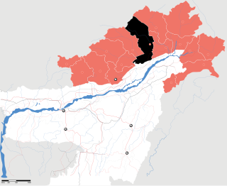
East Siang is an administrative district in the state of Arunachal Pradesh in India.
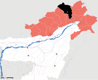
West Siang is an administrative district in the state of Arunachal Pradesh in India.

Pasighat is the headquarters of East Siang district in the Indian state of Arunachal Pradesh. Situated at the eastern foothills of the Himalayas at 155 meters (509 ft) above mean sea level, Pasighat is Arunachal's oldest town. The Government of India included Pasighat in the Smart Cities Mission development scheme in June 2017.

Yingkiong is a town and the administrative headquarters of Upper Siang district in the Northeast Indian state of Arunachal Pradesh. It is a small town located 250 kilometres (160 mi) to the north of Itanagar,which is the capital of Arunachal Pradesh. and around 1 kilometre (0.62 mi) east of the River Siang in Upper Siang district of Arunachal Pradesh. Yingkiong town is located at an elevation of 200 metres (660 ft) above sea level. To the west of Yingkiong flows the Siang River, which is geographically known by different other names based on region where it flows as the Brahmaputra River in the Assam Region and Yarlung Zangbo/Tsangpo in Tibet. According to the 2011 Census, the town has a total population of 8,573 persons.
Mouling National Park is a national park located in the Indian state of Arunachal Pradesh, spread primarily over the Upper Siang district and parts of the West Siang and East Siang district. It was the second national park to be created in the state, after Namdapha National Park in 1972. The Mouling National Park and the Dibang Wildlife Sanctuary are located fully or partly within Dihang-Dibang Biosphere Reserve.

Menchukha is a small town situated 6,000 feet (1,829 m) above sea level in the Mechuka Valley in Shi-Yomi District of Arunachal Pradesh, India. Name of current MLA (June-2019) of Mechuka constituency is Pasang Dorjee Sona. After Menchuka the McMahon border separates Indian territory and Chinese territory.
Upper Siang is an administrative district in the state of Arunachal Pradesh in India. It is the fourth least populous district in the country.
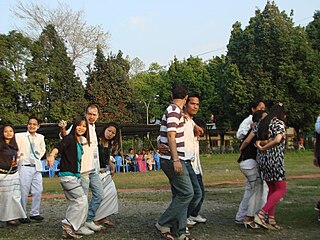
The MopinFestival is an agricultural festival celebrated by the Galo tribe of Arunachal Pradesh, India in particular of the Galo group of tribes which resides in East Siang and West Siang districts. It is a celebration of the harvesting season held in the Galo months of "Lumi" and "Luki", corresponding to March–April and the new year for the Galo tribe. The Galo tribe follow an animist religion called Donyi-Polo.

The Bori are an indigenous tribe of the Adi people living in the districts of East Siang, Upper Siang, Siang and West Siang in the Indian state of Arunachal Pradesh.
Rani Village or Rani is a small village located in the Sille-Oyan circle of East Siang district, Arunachal Pradesh with a total of 924 residing families. It is situated 12 km from the district headquarter Pasighat and the 3rd largest village in the East Siang district, after Riga Village and Mirem Village.
Arunachal Frontier Highway, also Mago-Thingbu–Vijaynagar Border Highway, is a planned border highway in the Indian state of Arunachal Pradesh. The 2,000-kilometre-long (1,200 mi) road follows the McMahon Line, the international border between India and China. The Government of India estimates the cost at ₹40,000 crore.

Gomsi is an ancient archaeological site located between Rani Village and Sika Tode in East Siang District, Arunachal Pradesh, India. It is associated with the 13th-century Chutiya Kingdom, which was located at the field of Rani Village, about 15 km from the town of Pasighat.
Kerang Village is a small village reside at West Siang District, Arunachal Pradesh.
Siang District is the 21st district of Arunachal Pradesh State, India. This district was created by bifurcating West Siang and East Siang districts of Arunachal Pradesh consisting of 32-Rumgong-Kaying and 35-Boleng-Pangin Constituencies. The district was inaugurated on 27 November 2015 by Chief Minister Nabam Tuki.
Sine is a village in the Boleng Circle of East Siang District, Arunachal Pradesh.
Pangin is a town in Siang district, for which it is the headquarters. Prior to the creation of Siang district in 2015 the town had been in East Siang district.
Shi Yomi district is one of the 23 districts of Arunachal Pradesh state in northeastern India. Shi-Yomi district was created on 9 December 2018 by dividing the West Siang district when northern areas along the China border were made into a newly created Shi-Yomi district and the remaining southern areas remains the part truncated West Siang district. It has its headquarters at Tato.