According to a mythological tradition mentioned in the medieval kaifiyat (bureaucratic record), the site of the village was once a hermitage of the sage Mandavya. Rama installed a shivalinga, called Rameshvara, on the local hill after defeating Ravana. A Chola king later built a Shiva temple and tank to the south-west of the present-day town centre, to atone for his sin of killing a Brahmin. A village called Mandavya-palle developed around the temple. It came to be known as Madakasira, because the majority of the inhabitants were potters who manufactured madakas (earthen pots).[5]
In the 17th century, the area was under the suzerainty of the Vijayanagara Empire and the Bijapur Sultanate.[6] The members of the family that established present-day Madakasira, near the former village of Madakapalle, were apparently chiefs of Sira. After defeating Vijayanagara and capturing Sira, the Bijapur rulers granted Madakapalle and the nearby Ratnagiri to these chiefs. The rulers of Bijapur revoked and restored the grant several times.[7]
In various historical records, the name of the village appears as "Marke Sira", "Merg Sera", "Marcassira", and "Madaksira".[9][6]
Geography
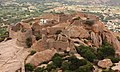
Madakasira is located at 13°56′13″N77°16′10″E / 13.9369°N 77.2694°E / 13.9369; 77.2694.[10] It has an average elevation of 676metres (2221ft). The height of the Madakasira hill is 2936 feet from the Sea Level.Formerly Madakasira is called as SIMHAGIRI because hill from one side looks like a sleeping lion. Around Madakasira there are numerous isolated Peaks and Rocky Clusters which are devoid of any vegetation. Madakasira town is cooler compared to the climate of elsewhere in Sri Sathya Sai District, hence aptly known as Ooty of Sri Sathya Sai District.[citation needed]
There are more than 20 villages in the Madakasira Mandal, they are Halukur, Amidalagondi, Eguva Ramagiri, Maruvapalli, E Achampalli, Kothalam, Chandakacherela, Gowdanahalli, R Anantapuram, Chatram, Mallinayakkanahalli, Cheepuleti, Madakasira, Melavoi, Govindapuram, Jadrahalli, Karesankanahalli, Yerrabommanahalli, Upperlahalli, Haresamudram, Bullasamudram, Manur, Kallumarri, C Kodigapalle and Thirumaladevarahalli. Mandals in this Assembly region are Madakasira, Amarapuram, Rolla, Gudibanda and Agali.[citation needed]
Historical places
Besides the Madakasira Fort, there are many historical places in and around Madakasira, including Shiva temples and inscriptions. The hill on which the fort is located has a temple built during the Vijayanagara rule. The town has recently constructed a large Shirdi Sai Baba Temple.[11]
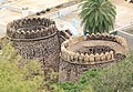
Madakasira Fort
Madakasira Fort -Large bastion
Madakasira Fort - Old gateway
Education
The medium of education is Telugu, Kannada and English, Acharya N. G. Ranga Agricultural University's College of Agricultural Engineering is there in Madakasira town Near Tulasidaama vruddasramam Village, Penukonda Road. There is branch of Karnataka Bank at Madakasira[12]
Demographics
There are 120 Yadav dominated villages in the Madakasira assembly constituency.[13]
Indian census, 2001, the demographic details of Madakasira mandal is as follows:[14]
Total Population: 73,222 in 15,413 Households.
Male Population: 37,344 and Female Population: 35,878
Children Under 6-years of age: 9,709 (Boys - 4,972 and Girls – 4,739)
This page is based on this Wikipedia article Text is available under the CC BY-SA 4.0 license; additional terms may apply. Images, videos and audio are available under their respective licenses.