Telangana is a state in India situated in the southern-central part of the Indian peninsula on the high Deccan Plateau. It was the eleventh largest state and the twelfth most populated state in India as per the 2011 census. On 2 June 2014, the area was separated from the northwestern part of United Andhra Pradesh as the newly formed state of Telangana, with Hyderabad as its capital.

Rayalaseema is a geographic region in the Indian state of Andhra Pradesh. It comprises four southern districts of the State, from prior to the districts reorganisation in 2022, namely Kurnool, Anantapur, YSR, and Chittoor. Four new districts were created from these, namely Sri Sathya Sai, Nandyal, Annamayya, and Tirupati. As of 2011 census of India, the western four districts of the region had a population of 15,184,908 and cover an area of 77,424 km2 (29,894 sq mi).

Madhavrao I was the son of Peshwa Balaji Bajirao and grandson of Peshwa Bajirao I who served as 9th Peshwa of the Maratha Confederacy. During his tenure, the Maratha Confederacy recovered from the losses they suffered during the Third Battle of Panipat, an event known as Maratha Resurrection.

Adoni is a city in the Kurnool district in the Indian state of Andhra Pradesh. It is a municipality and the headquarters of Adoni mandal, administered under the Adoni Revenue Division. In the 2011 census of India, Adoni had a population of 166,344, making it the 16th most populous town in the state with an urban agglomeration population of 184,625.

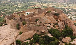
Gooty is a town in Anantapur district of the Indian state of Andhra Pradesh. It is the headquarters of Gooty mandal in Anantapur revenue division. The town is renowned for the Gooty hill fort.

Anantapur district, officially Anantapuramu district, is one of the eight districts in the Rayalaseema region of the Indian state of Andhra Pradesh. The district headquarters is located in Anantapur city. It is one of the driest places in South India. In the year 2022, as part of re-organisation of districts, Sri Sathya Sai district was carved out.

Kadapa district is one of the twenty six districts in the Indian state of Andhra Pradesh. In 2022 reorganisation of Andhra Pradesh districts, the district boundary is largely restricted to Kadapa parliamentary constituency area. It is also one of the eight districts in the Rayalaseema region. Kadapa is the administrative headquarters for this district.

Kurnool district is one of the eight districts in the Rayalaseema region of the Indian state of Andhra Pradesh after the districts are reorganised in April 2022. It is located in the north western part of the state and is bounded by Nandyal district in the east, Anantapur district in the south, Raichur district of Karnataka in the northwest, Bellary district of Karnataka in the west, and Jogulamba Gadwal district of Telangana in the north. It has a population of 2,271,686 based on the 2011 census. The city of Kurnool is the headquarters of the district.

Mahabubnagar district is a district in the Indian state of Telangana. Mahabubnagar is the district headquarters which is popularly known as Palamoor. The district shares boundaries with Narayanapet, Vikarabad, Rangareddy, Nagarkurnool, Wanaparthy and Jogulamba Gadwal districts. The district was formed during the period of the 6th Nizam of Hyderabad State – Nawab Mir Mahbub Ali Khan and hence named after him.

Penukonda also called Penugonda is a town in the Sri Sathya Sai district of Andhra Pradesh, India. It is 70 km away from Anantapur town.
Bankapura is a panchayat town in Haveri district in the state of Karnataka, India. It is in Shiggaon taluk, is just 2.5 km from the Pune-Bangalore national highway NH-4, 22 km from Haveri town. Bankapura is about 45 km from Hubli-Dharwad. An historical site, Bankapura is famous for the Nagareshwara temple, Bankapura fort, The Bankapura Peacock Sanctuary. Baada, the birthplace of Kanakadasa is near to Bankapura.

The Carnatic Sultanate was a kingdom in South India between about 1690 and 1855, and was under the legal purview of the Nizam of Hyderabad, until their demise. They initially had their capital at Arcot in the present-day Indian state of Tamil Nadu. Their rule is an important period in the history of the Carnatic and Coromandel Coast regions, in which the Mughal Empire gave way to the rising influence of the Maratha Empire, and later the emergence of the British Raj.

Jaigad Fort(Marathi: जयगड किल्ला, Jayagaḍa killā) is a coastal fortification that is located at the tip of a peninsula in Jaigad, Ratnagiri District at a distance of 14 km from the temple town of Ganpatipule, in the state of Maharashtra, India. Nestled on a cliff, it overlooks a bay formed where the Shastri river enters the Arabian Sea. It has a commanding view of the bay, the nearby power plant and the open sea. A jetty port Angrey, and a lighthouse is located nearby. Although in ruins, most of the fort's outer wall and ramparts still stand. A deep moat surrounds the fort side not facing the cliff edge. In the middle of the 13 acre fort lies the palace of Kanhoji Angre, a Ganpati temple and wells to store water. It is a protected monument.

North Andhra or Uttara Andhra, also known as Kalinga Andhra, is a geographic region in the Indian state of Andhra Pradesh. It is between the Eastern Ghats and the coast of the Bay of Bengal. It comprises six northern districts of the state, Srikakulam, Parvathipuram Manyam, Vizianagaram, Visakhapatnam, Alluri Sitharama Raju and Anakapalli. As of 2011 census of India, the region with six districts has a population of 9,338,177.

Sirpur (T) is a town and a mandal in Komaram Bheem district of the Indian state of Telangana.
Madakasira is a town with a population 19,432 in 2001 and also a mandal in Sri Satya Sai district in the state of Andhra Pradesh in India. It is located near the state border with Karnataka. The Madakasira Hill Fort in the town is a centrally protected monument of national importance.

The Siege of Trichinopoly was part of an extended series of conflicts between the Nizam of Hyderabad and the Maratha Empire for control of the Carnatic region. On 29 August 1743, after a six-month siege, Murari Rao surrendered, giving Nizam ul Mulk (Nizam) the suzerainty of Trichinopoly. By the end of 1743, the Nizam had regained full control of Deccan. This stopped the Maratha interference in the region and ended their hegemony over the Carnatic. The Nizam resolved the internal conflicts among the regional hereditary nobles (Nawabs) for the seat of governor (Subedar) of Arcot State, and monitored the activities of the British East India company and French East India Company by limiting their access to ports and trading.
Murari Rao Ghorpade (1699-1779), known simply as Murari Rao, was an army general in the Maratha Army from Gooty who administered the fort of Tiruchirappalli and surrounding areas from 1741 to 1743. His administration marks the only period of Maratha occupation in Tiruchirappalli. Murari Rao occupied Tiruchirappalli at the head of a strong Maratha army after defeating and imprisoning the Carnatic general Chanda Sahib. However, he was forced to relinquish the fort by Asaf Jah. The Nizam sieged Trichinopoly for four months, and after receiving no reinforcements, Murari Rao was eventually bought off by the Nizam and handed the fort over to him on 29 August 1743. Murari Rao Ghorpade was the founder of the Ghati Subramanya Temple and the Makalidurga Fort.

The history of Telangana, located on the high Deccan Plateau, includes its being ruled by the Satavahana Dynasty, the Kakatiya Dynasty (1083–1323), the Musunuri Nayaks (1326–1356), the Delhi Sultanate, the Bahmani Sultanate (1347–1512), Golconda Sultanate (1512–1687) and Asaf Jahi dynasty (1724–1950).

Ratnagiri Fort is a hill fort located in the Ratnagiri village near Rolla, in Sri Sathya Sai district of Andhra Pradesh, India. Located near the border of Andhra Pradesh and Karnataka in the Rayalaseema region, it is also known as Seema Golconda. The Government of India has designated it as a Monument of National Importance.