Gurramkonda Fort

Last updated

Gurramkonda Fort
گرمکنڈہ قلعه - గుర్రంకొండ కోట
Gurramkonda in India
Gurramkonda Hill Fort.jpg
Gurramkonda Fort
India Andhra Pradesh location map (current).svg
Red pog.svg
Gurramkonda Fort
India location map.svg
Red pog.svg
Gurramkonda Fort
Coordinates 13°46′36.6″N78°35′10″E / 13.776833°N 78.58611°E / 13.776833; 78.58611
TypeFort
Site information
OwnerArchaeological Survey of India Chittoor
OperatorASI Chittoor
Controlled byASI Chittoor
Open to
the public
Public
Site history
Built14th Century (14th Century)

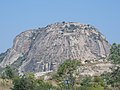
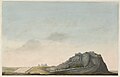
Gurramkonda fort is Hill fort in erstwhile Chittoor district now Annamayya district of the Indian state of Andhra Pradesh. It is located in the village Gurramkonda, the mandal headquarters. It is considered one of the oldest forts in the district.

Contents

According to sources this fort was built during Vijayanagara Empire and later it came in control of Abdul Khan, the Nawab of Kadapa, in the year 1714 CE. [1] [2]

History

There is a strong fort on the hill. It was built by Vijaya Nagar Empire kings in 14th CE. [3] Even today, it is worthy of visit and mentioning. [4]

Places to visit

  1. Rangin Mahal Gurramkonda . [5]
  2. Ananta Padmanabha Temple
  3. Water pond on the peak of the hill.
  4. Syed shah Durgah

Related Research Articles

<span class="mw-page-title-main">Chittoor</span> City in Andhra Pradesh, India

Chittoor is a city and district headquarters in Chittoor district of the Indian state of Andhra Pradesh. It is also the mandal and divisional headquarters of Chittoor mandal and Chittoor revenue division respectively. The city has a population of 153,756 and that of the agglomeration is 175,647.

<span class="mw-page-title-main">Chandragiri</span> Neighborhood of Tirupati in Andhra Pradesh, India

Chandragiri is a suburb and neighbourhood of Tirupati and located in Tirupati district of the Indian state of Andhra Pradesh. It is a part of Tirupati urban agglomeration and a major growing residential area in Tirupati It is the mandal headquarters of Chandragiri mandal in Tirupati revenue division. It also falls in the jurisdictional limit of Tirupati Urban Development Authority. Chandragiri is the southwestern entrance of Tirupati for vehicles coming from Bangalore, Kerala and Tamil Nadu. Kalyana Venkateswara Temple, Srinivasamangapuram is located next to Chandragiri through which well-laid stone footpaths called srivari mettu are available to reach Tirumala on foot

<span class="mw-page-title-main">Gooty</span> Town in Andhra Pradesh, India

Gooty is a town in Anantapur district of the Indian state of Andhra Pradesh. It is the headquarters of Gooty mandal in Anantapur revenue division. The town is renowned for the Gooty hill fort.

<span class="mw-page-title-main">Tirupati</span> City in Andhra Pradesh, India

Tirupati is a city in the Indian state of Andhra Pradesh. It is the administrative headquarters of the Tirupati district. The city is home to the important Hindu shrine of Tirumala Venkateshwara Temple and other historic temples It is located at a distance of 150 km from Chennai, 250 km from Bangalore. It is one of the eight Svayam vyakta kshetras dedicated to Vishnu. Tirupati is a municipal corporation and the headquarters of Tirupati (urban) mandal, Tirupati (rural) mandal, and the Tirupati revenue division.

<span class="mw-page-title-main">Kadapa district</span> District of Andhra Pradesh in India

Kadapa district is one of the twenty six districts in the Indian state of Andhra Pradesh. In 2022 reorganisation of Andhra Pradesh districts, the district boundary is largely restricted to Kadapa parliamentary constituency area. It is also one of the eight districts in the Rayalaseema region. Kadapa is the administrative headquarters for this district.

<span class="mw-page-title-main">Kadapa</span> City Corporation in Andhra Pradesh, India

Kadapa is a city in the southern part of Andhra Pradesh, India. It is located in the Rayalaseema region, and is the district headquarters of YSR Kadapa district. As of the 2022 Census of India, the city had a population of 466,000, a 2.42% increase from 2021. It is located 8 kilometres (5.0 mi) south of the Penna River. The city is surrounded on three sides by the Nallamala and Palkonda Hills lying on the tectonic landscape between the Eastern and Western ghats. Black and Red ferrous soils occupy the region. The city is nicknamed "Gadapa" ('threshold') since it is the gateway from the west to the hills of Tirumala.

<span class="mw-page-title-main">Telugu Chodas</span> Rulers of Andhra Pradesh, 6th-13th century

The Telugu Chodas or Telugu Cholas ruled parts of present-day Andhra Pradesh between the sixth and the thirteenth century as subordinates of Pallavas and later under Chola dynasty. The earliest Choda family in the Telugu area was that of Renati Chodas, which claimed descent from Karikala Chola. Other Choda dynasties include Velanati, Pottapi, Konidena, Nannuru, Nellore etc.

<span class="mw-page-title-main">Gurramkonda</span> Village Gurrumonda in Andhra Pradesh, India

Gurramkonda is a village in Annamayya district of the Indian state of Andhra Pradesh. It is the Mandal headquarters of Gurramkonda Mandal. Gurramkonda Fort is one of the oldest fort in the district. Gurramkonda (village) is a village in the Gurramkonda Mandal of the state of Andhra Pradesh, Annamayya district. It is located at a distance of 0 km from the center of the zones, Horamkonda. It is 35 km from the nearest town, Madanapalle. Is also in the distance. As per the 2011 census of India, the village is spread over 3111 hectares with 2501 houses and a population of 10642. The number of males in the village is 5480, the number of females is 5162. The Scheduled Castes population is 511 and the Scheduled Tribes population is 126. The census location code of the village is 595648. [1]. 13.7833 ° N 78.5833 ° E. on the road to Kadapa, Kadapa, Bangalore [2] The sea can reach 647 meters. The town is a tourist hotspot. It is also historically known as Jaffarabad. Located on Kadapa-Bengaluru Road, this horse-hill is a popular tourist attraction with its historical background. It is a communal harmony with the Hindu and Muslim cultures of the day.

<span class="mw-page-title-main">Gandikota</span> Place in Andhra Pradesh, India

Gandikota is a village and historical fort on the right bank of the Penna river, 15 km from Jammalamadugu in Kadapa district, Andhra Pradesh, India. The fort was the centre of power for various dynasties, such as the Kalyani Chalukyas, Pemmasani Nayakas, and the Golconda Sultanate. A sand fort was constructed by Kaka Raja, Vassals of Kalyani Chalukya rulers. Various additions of Islamic architecture were made during subsequent Muslim rule.

<span class="mw-page-title-main">North Arcot</span>

North Arcot was a former district in Madras Presidency, acquired by the annexation of the Arcot State in 1855 when its Nawab died without issue. It had Chittoor as its headquarters. On 1 April 1911, the Chittoor district was separated from North Arcot. The remaining district, with Vellore as its headquarters, passed intact into the Madras State of independent India. On 30 September 1989 the district was split into Tiruvannamalai-Sambuvarayar district and North Arcot Ambedkar district. It contained the present day districts of Tiruvannamalai, Vellore, Chittoor, Tirupati, Tirupattur and Ranipet.

Rayachoti is a town and District headquarters of Annamayya district which is formed after Rajampet of the Indian state of Andhra Pradesh. It is a municipality in Rayachoti Mandal (Tehsil) of the Rayachoti revenue division. It is one of the oldest towns in Andhra Pradesh.

<span class="mw-page-title-main">Allagadda</span> Town in Andhra Pradesh, India

Allagadda is a town in Nandyal district of the Indian state of Andhra Pradesh. It is located in Nandyal Revenue division. Allagadda Town Council is the 5th largest ULB in the Kurnool district of Andhra Pradesh. It was established as Town Council in the year 2011. It is located at 15°08’00” N 78°31.00 E Coordinates 15°08’00” N 78°31’00” E. It is the Headquarters of the Mandal as well as the Revenue Division and is located at about 40 km, from Allagadda, the district headquarters. It is located 40 km from Allagadda is on National Highway 40 and is the border of the districts Kurnool and Kadapa. It is situated 30 km from Ahobilam is Major Pilgrim Centre in Allagadda Mandal. It has an extent of 62.30 km2.

<span class="mw-page-title-main">Nandalur</span> Village in Andhra Pradesh, India

Nandalur is a village in Annamayya district of the Indian state of Andhra Pradesh. It is located in Nandalur mandal of Rajampeta revenue division. It is 10 km from Rajampet and 42 km from the District headquarters of the Cuddapah district on the State Highway connecting Cuddapah with Tirupati. It is located on the Cuddapah-Chennai highway, 38 km from Cuddapah and 11 km from Rajampeta. It is also close to other pilgrimage centres in Cuddapah district like Ontimitta, Polatala, Attirala and the famed birthplace of Sri Annamacharya, Tallapaka. It has an average elevation of 151 meters.

<span class="mw-page-title-main">Chandragiri Fort, Andhra Pradesh</span>

Chandragiri Fort is an historical fort, built in the 11th century located at Chandragiri suburb in Tirupati. It is situated in Tirupati district of Andhra Pradesh, India. Although mostly associated with the Vijayanagara Emperors, it was built much earlier in 11th century by the Yadava rulers. In 1460 A.D. Odra Gajapati Kapilendra Dev captured the Chandragiri Fort.

<span class="mw-page-title-main">Kadapa railway station</span>

Kadapa Junction railway station is the primary railway station serving the town of Kadapa in YSR Kadapa district, Andhra Pradesh, India. The station comes under the jurisdiction of Guntakal railway division of South Coast Railways. The station has three platforms. The station is situated in Guntakal–Chennai Egmore section of the Mumbai–Chennai line.

<span class="mw-page-title-main">Pushpagiri Temple Complex</span> Religious Complex in Andhra Pradesh, India

Pushpagiri Temple Complex is a temple complex located in Kadapa district in Andhra Pradesh, India. Founded around 7th Century CE, it houses some of the oldest temple congregations in the region.

<span class="mw-page-title-main">Tondaimandalam</span> Historical region in India

Tondaimandalam, also known as Tondai Nadu, is a historical region located in the northernmost part of Tamil Nadu and southernmost part of Andhra Pradesh. The region comprises the districts which formed a part of the legendary kingdom of Athondai Chakravarti. The boundaries of Tondaimandalam are ambiguous – between the river basins of Penna River and Ponnaiyar River. During the reign of Rajaraja I, this region was called as Jayankonda Cholamandalam.

Siddhavatam is a village in Kadapa district of the Indian state of Andhra Pradesh. It is located in Siddavatam mandal of Kadapa revenue division.

<span class="mw-page-title-main">Gudimallam</span> Village

Gudimallam is a village near Tirupati, located in Tirupati district of Andhra Pradesh state of India. It is situated about 15 kilometers southeast of Tirupati city. It is especially famous for the Gudimallam Lingam in the Parasurameswara Swamy Temple.

<span class="mw-page-title-main">Annamayya district</span> District in Andhra Pradesh in India created in 2022

Annamayya district is one of the eight districts in the Rayalaseema region of Andhra Pradesh, established in 2022. Rayachoti is the district administrative headquarters and Madanapalle is the most populated town in the district.

References

  1. "Archaeological Survey of India, Chittoor". Asihyd.ap.nic.in. Archived from the original on 20 May 2016. Retrieved 22 October 2017.
  2. C. F. Brackenbury (2000). District Gazetteer, Cuddapah. Asian Educational Services. p. 41. ISBN   978-81-206-1482-6 . Retrieved 20 October 2018.
  3. Brackenbury, C. F. (20 October 2018). District Gazetteer, Cuddapah. Asian Educational Services. p. 41. ISBN   9788120614826 via Google Books.
  4. "Shodhganga chapter". Shodhganga.inflibnet.ac.in.
  5. "Heavy downpour unearths ancient structure in Gurramkonda fort in Andhra Pradesh - the Times of India". The Times of India . 2 December 2015. Archived from the original on 4 December 2015. Retrieved 17 October 2018.