Gyalshing District or Geyzing District is a district of the Indian state of Sikkim. Its headquarter is Geyzing, also known as Gyalshing. The district is a favourite with trekkers due to the high elevations. Other important towns include Pelling and Yuksom. Local people also call it as Pallo-Sikkim and Sano-Sikkim commonly.
Ramanathapuram, also known as Ramnad, is a city and a municipality in Ramanathapuram district in the Indian state of Tamil Nadu. It is the administrative headquarters of Ramanathapuram district and the second largest town in Ramanathapuram district.

Ayodhya district is one of the 75 districts in the northern Indian state of Uttar Pradesh. The city of Ayodhya is its administrative headquarters. The district occupies an area of 2,522 square kilometres (974 sq mi), and had a population of 2,470,996 in the 2011 census. Ayodhya district shares its borders with 6 districts of Uttar Pradesh. It is bordered by Gonda and Basti districts on the northern side, Amethi and Sultanpur districts on the south, and Ambedkar Nagar and Barabanki districts share the border on the east and west.
Sattur or Saathur is a town in Virudhunagar district in the Indian state of Tamil Nadu. As of 2011, the town had a population of 29,398.

Tirunelveli district is one of the 38 districts of Tamil Nadu state in India. It is the largest district in terms of area with Tirunelveli as its headquarters. The district was formed on 1 September 1790 by the British East India Company and comprised the present Tirunelveli and Thoothukudi, Tenkasi and parts of Virudhunagar and Ramanathapuram district. As of 2011, the undivided district had a population of 30,77,233.
Paramakudi or Paramagudi is the largest town in the district of Ramanathapuram in Tamil Nadu, India, with a population of over 1,33000 as of 2024. It has been the taluk headquarters since the formation of Ramanathapuram District in 1918.
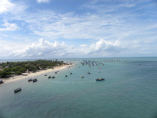
Ramanathapuram District, also known as Ramnad District, is one of the 38 districts an administrative districts of Tamil Nadu state in southern India. The old Ramanathapuram District consists of Present day Virudhunagar and Sivagangai districts, it touches the Western ghats and bordered with the state of Kerala and east by Bay of Bengal. It was the largest district on that time. The town of Ramanathapuram is the district headquarters. Ramanthapuram District has an area of 4,123 km2. It is bounded on the north by Sivaganga District, on the northeast by Pudukkottai District, on the east by the Palk Strait, on the south by the Gulf of Mannar, on the west by Thoothukudi District, and on the northwest by Virudhunagar District. The district contains the Pamban Bridge, an east–west chain of low islands and shallow reefs that extend between India and the island nation of Sri Lanka, and separate the Palk Strait from the Gulf of Mannar. The Palk Strait is navigable only by shallow-draft vessels. As of 2011, Ramanathapuram district had a population of 1,353,445 with a sex-ratio of 983 females for every 1,000 males. The district is home to the pilgrimage centre of Rameswaram and tourist spot Dhanushkodi, an abandoned town.

Indore District is a district of Madhya Pradesh state in central India. It is believed that the city is named after its Indreshwar Mahadev Temple, Where Indra is the presiding deity. The Gupta inscriptions name Indore as "Indrapura". It is also called the administrative capital. This district forms part of the Indore Division.

Imphal West district is one of the sixteen districts of Manipur state in northeastern India. As of 2011, it is the most populous district in the state.

Sivaganga District is one of the 38 districts in Tamil Nadu state, India. This district was formed on 15 March 1985 by trifurcation of Ramanathapuram district into Ramanathapuram, Virudhunagar and Sivaganga districts. Sivaganga is the district headquarters, while Karaikudi is the most populous city in the district, administered by the Karaikudi Municipal Corporation. It is bounded by Pudukkottai district on the Northeast, Tiruchirappalli district on the North, Ramanathapuram district on South East, Virudhunagar district on South West and Madurai district on the West. The area's other larger towns include Sivaganga, Kalayar Kovil, Devakottai, Manamadurai, Ilaiyangudi, Thiruppuvanam, Singampunari and Tiruppattur. As of 2011, the district had a population of 1,339,101 with a sex ratio of 1,003 females for every 1,000 males.

Pudukkottai District is one of the 38 districts of Tamil Nadu state in southern India. The city of Pudukkottai is the district headquarters. It is also known colloquially as Pudhugai. The city is also known as Thondaiman Pudukkottai.
Virudhunagar District is a district of Tamil Nadu state in south India. Virudhunagar is the district headquarters of Virudhunagar district. Virudhunagar district was formed by the separation of Old Ramanathapuram District G.O passed on 08,March 1985 & formed in 15,March 1985 into Ramanathapuram District, Sivagangai District and the west part as Virudhunagar District. Virudhunagar District was formerly called Karmavirer Kamarajar District. As of 2011, Virudhunagar district had a population of 1,942,288 with a sex-ratio of 1,007 females for every 1,000 males. Sivakasi is the most populous and largest city in the district.

Thiruthuraipoondi is a municipality in Tiruvarur district in the Indian state of Tamil Nadu. Thiruthuraipoondi is an agricultural town located south of Thiruvarur district. The town is located at a distance of 28 km (17 mi) from the district headquarters Thiruvarur.

Thiruvarur district is one of the 38 districts in the Tamil Nadu state of India. As of 2011, the district had a population of 1,264,277 with a sex-ratio of 1,017 females for every 1,000 males.
Odaikkarai is a village in Tiruvadanai Taluk, Ramanathapuram District, Tamil Nadu, India. It is located near the southern tip of the Indian subcontinent, about 43 kilometres north of the district seat Ramanathapuram, and 15 kilometres west of the taluk seat Tiruvadanai. As of the year 2011, it had a population of 394.

Khunti district is one of the twenty-four districts in South Chotanagpur division of the Indian state of Jharkhand. The district of Khunti was carved out of Ranchi district on 12 September 2007. As of 2011, it is the second least populous district of Jharkhand, after Lohardaga. Khunti town is the headquarters of the district. It is historically known as the birthplace of Birsa Munda, and being the centre of activity of the Birsa movement. It is the part of State Capital Region (SCR).

Khed taluka is a taluka in the subdivision, near Pune city in Pune district of the state of Maharashtra in India. Rajgurunagar is the headquarter of the taluka. The taluka is known for being the birthplace of Santaji Jagnade.The name of city is Rajgurunagar on the name of Shivram Hari Rajguru.
Pirappan Valasai is a village in Mandapam block in Ramanathapuram District of Tamil Nadu, India.