Related Research Articles

Archaeology and geology continue to reveal the secrets of prehistoric Scotland, uncovering a complex past before the Romans brought Scotland into the scope of recorded history. Successive human cultures tended to be spread across Europe or further afield, but focusing on this particular geographical area sheds light on the origin of the widespread remains and monuments in Scotland, and on the background to the history of Scotland.

Bijnor is a city and a municipal board in Bijnor district in the state of Uttar Pradesh, India.
Kuthannoor is a gram panchayat in the Palakkad district, state of Kerala, India. It is a local government organisation that serves the villages of Kuthannur-I and Kuthannur-II. It is a part of the Tharoor assembly constituency.

In the prehistory of the Indian subcontinent, the Iron Age succeeded Bronze Age India and partly corresponds with the megalithic cultures of India. Other Iron Age archaeological cultures of India were the Painted Grey Ware culture and the Northern Black Polished Ware. This corresponds to the transition of the Janapadas or principalities of the Vedic period to the sixteen Mahajanapadas or region-states of the early historic period, culminating in the emergence of the Maurya Empire towards the end of the period.

The dolmens of Jersey are neolithic sites, including dolmens, in Jersey. They range over a wide period, from around 4800 BC to 2250 BC, these dates covering the periods roughly designated as Neolithic, or “new stone age”, to Chalcolithic, or “copper age”.
The Kupgal petroglyphs are works of rock art found at Kupgal in Bellary district of Karnataka, India. Thousands of petroglyphs have been found at Kupgal, which date to the neolithic or even the old stone age. The site, which includes examples of rock gongs, was discovered first in 1892, but subsequently became lost to researchers until it was rediscovered in the early 21st century. This site features peculiar rock formations with unusual depressions which make musical sounds when struck with boulders.

Chandravalli is an archaeological site located in the Chitradurga district of the state of Karnataka, India. The region is a valley formed by three hills, Chitradurga, Kirabanakallu and Jolagudda. It is a semi-arid region with scrub vegetation with a stream running through it. Excavations at Chandravalli have revealed earthen pots, painted bowls and coins of Indian dynasties like Vijayanagar, Satavahana and Hoysalas as well as denarii of Roman emperor Augustus Caesar and a coin of the Chinese Han dynasty Emperor Wu Ti belonging to 2nd Century BC.
Kallur is an archaeological site and village located in the Manvi taluk of Raichur district in the state of Karnataka, India. It belongs to Gulbarga division. The site came into prominence with the discovery of antennae swords in the 1930s, which was the first instance of the Copper Hoard culture being discovered in South India. The earliest finding here has been dated to the Neolithic period.

Maski is a town and an archaeological site in the Raichur district of the state of Karnataka, India. It lies on the bank of the Maski river which is a tributary of the Tungabhadra. Maski derives its name from Mahasangha or Masangi. The site came into prominence with the discovery of a minor rock edict of Emperor Ashoka by C. Beadon in 1915. It was the first edict of Emperor Ashoka that contained the name Ashoka in it instead of the earlier edicts that referred him as Devanampiye piyadasi. This edict was important to conclude that many edicts found earlier in the Indian sub-continent in the name of Devanampiye piyadasi, all belonged to Emperor Ashoka. The edict is etched on a rock-face of Durgada-gudda, one of the gneissic outcrops that are present in the site.
Alamgirpur is an archaeological site of the Indus Valley civilization that thrived along Yamuna River from the Harappan-Bara period, located in Meerut district, Uttar Pradesh, India. It is the easternmost known site of the civilization.
Daimabad is a deserted village and archaeological site on the left bank of the Pravara River, a tributary of the Godavari River in Shrirampur taluka in Ahmednagar district of Maharashtra state in India. This site was discovered by B. P. Bopardikar in 1958. It has been excavated three times so far by the Archaeological Survey of India teams. The first excavation in 1958-59 was carried out under the direction of M. N. Deshpande. The second excavation in 1974-75 was led by S. R. Rao. Finally, the excavations between 1975-76 and 1978-79 were carried out under the direction of S. A. Sali. Discoveries at Daimabad suggest that Late Harappan culture extended into the Deccan Plateau in India. Daimabad is famous for the recovery of many bronze goods, some of which were influenced by the Harappan culture.
Amalananda Ghosh was an Indian archaeologist, author and editor of numerous works on India's ancient civilizations, and the organizer and director of archaeological expeditions during the mid-1900s.
Loteshwar is a village and an archaeological site belonging to Indus Valley civilisation located at Patan district, Gujarat, India. This site is locally also known as Khari-no-timbo and located on a high sand dune on left bank of Khari river, a tributary of Rupen river.

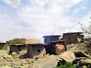
Hirebenakal or Hirébeṇakal or Hirébeṇakallu is a megalithic site in the state of Karnataka, India. It is among the few megalithic sites in India that can be dated to the 800 BCE to 200 BCE period. The site is located in the Koppal district, some 10 kilometres (6.2 mi) west of the town of Gangavati and some 35 kilometres (22 mi) from Hospet city. It contains roughly 400 megalithic funerary monuments, that have been dated to the transition period between Neolithic period and the Iron Age. Known locally as eḷu guḍḍagaḷu, their specific name is moryar guḍḍa. Hirebenakal is reported to be the largest necropolis among the 2000 odd megalithic sites found in South India, most of them in the state of Karnataka. Since 1955, it has been under the management of the Dharwad circle of the Archaeological Survey of India (ASI). On May 19, 2021, it was proposed that Hirebenakal be made a UNESCO World Heritage Site.

The stone circles of Junapani are prehistoric megalithic circles in Junapani, near Nagpur in the Indian state of Maharashtra. There are about 300 such stone circles noted around Junapani. They were first excavated by J. H. Rivett-Carnac in 1879, yielding a variety of iron objects including daggers, flat axes with cross-ring fasteners, hoes, rings, bracelets, horse bits, chisels with long blades, and pointed tongs, possibly covered with a wooden handle. There is also evidence of black and red pottery, such as bowls featuring linear paintings in black. The burial sites were characterized by cairns. About 150 stone circles have been studied and documented. A notable feature is the cup-marked stones in the circles which seem to suggest an astronomical significance. This aspect has been discerned from the fact that the cup-marked stones are fixed at specific locations denoting specific directions.
Sanganakallu is an ancient archaeological site from the Neolithic period. It is approximately 8 km from Bellary in eastern Karnataka. It is a group of hills south of a horseshoe shaped valley, with Kupgal to the north. It is one of the earliest settlements in South India, spread over 1,000 acres. There is a layer of red-brown fossilized soil spread over Sanganakallu and Kupgal that can be dated back to 9000 BC. The site is considered to be a neolithic factory site due to the surface excavation revealing large numbers of pottery, stone axes, and other stone tools. The site was first majorly excavated in 1946, by Bendapudi Subbarao, on Sannarasamma hill. Subbarao divided their culture into 3 phases:

Sidlaphadi near Badami in Karnataka, is a natural rock bridge and prehistoric rock shelter. It is located at about four km. in the middle of a shrub jungle near the historic town of Badami. A bridle and kutcha path through sandstone hills from Badami leads to Sidlaphadi and there is no metal road to the spot. Sidlaphadi literally means in Kannada the Rock of lightning, derived from gaping holes in the natural rock arch, which was formed when a lightning struck. The natural rock bridge structure looks like a wide arch between two sandstone boulders. The rock structure has large, gaping holes in the arch and allows sunlight to enter inside which provides the required light for interiors. It was also a shelter for hunter-gatherer prehistoric people.

The Ibbankatuwa Megalithic Tombs is an ancient burial site located near Ibbankatuwa Wewa in Galewela DS, Sri Lanka. The site is thought to belong to the megalithic prehistoric and protohistoric periods of Sri Lanka and is considered one of the several ancient burial sites that have been found in the country. The site is situated on the Kurunegala - Dambulla road approximately five kilometers southwest of Dambulla town. Currently, the tomb site has been designated an archaeological protected site in Sri Lanka.

Archaeology in India is mainly done under the supervision of the Archaeological Survey of India.
Saridkel is an ancient site located in the khunti district of Jharkhand. There are ancient ruins of burnt brick houses found on the site along with redware pottery, copper tools, coins, gold earrings and iron tools. Well fortified buildings suggest that it was probably a royal house or Monastery belonging to the 1st or 2nd century CE, according to the archeological department.
References
- Arjun. R (1 September 2018. "Archaeological Investigations at the Brhamagiri rock shelter: Prospecting for its context in South India late prehistory and early history". Archaeological Research in Asia. 15: 1-12. doi:10.1016/j.ara.2016.12.003. ISSN 2352-2267.
- Ghosh, Amalananda (1990) [1990]. An Encyclopaedia of Indian Archaeology. BRILL. ISBN 90-04-09262-5.
- Kennedy, Kenneth A. R. (2000) [2000]. God-Apes and Fossil Men: Paleoanthropology of South Asia. University of Michigan Press. ISBN 0-472-11013-6.
- Peter N. Peregrine; Melvin Ember; Human Relations Area Files Inc. (2001) [2001]. Encyclopedia of Prehistory. Springer. ISBN 0-306-46262-1.
- Kipfer, Barbara Ann (2000) [2000]. Encyclopedic Dictionary of Archaeology. Springer. ISBN 0-306-46158-7.
- Ian Shaw; Robert Jameson (1999) [1999]. A Dictionary of Archaeology. Blackwell Publishing. ISBN 0-631-23583-3.