Related Research Articles
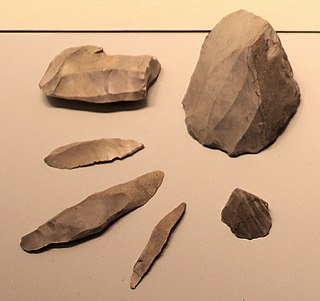
A microlith is a small stone tool usually made of flint or chert and typically a centimetre or so in length and half a centimetre wide. They were made by humans from around 35,000 to 3,000 years ago, across Europe, Africa, Asia and Australia. The microliths were used in spear points and arrowheads.
The 10th millennium BC spanned the years 10,000 BC to 9001 BC. It marks the beginning of the transition from the Palaeolithic to the Neolithic via the interim Mesolithic and Epipaleolithic periods, which together form the first part of the Holocene epoch that is generally reckoned to have begun c. 9700 BC and is the current geological epoch. It is impossible to precisely date events that happened around the time of this millennium and all dates mentioned here are estimates mostly based on geological and anthropological analysis.

In archaeological terms, a projectile point is an object that was hafted to weapon that was capable of being thrown or projected, such as a spear, dart, or arrow, or perhaps used as a knife. They are thus different from weapons presumed to have been kept in the hand, such as axes and maces, and the stone mace or axe-heads often attached to them.
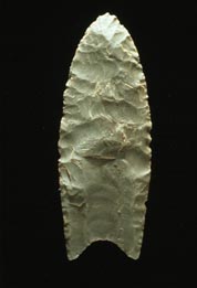
Clovis points are the characteristically-fluted projectile points associated with the New World Clovis culture. They are present in dense concentrations across much of North America; in South America, they are largely restricted to the north of that continent. Clovis points date to the Early Paleoindian period roughly 13,500 to 12,800 calendar years ago. Clovis fluted points are named after the city of Clovis, New Mexico, where examples were first found in 1929 by Ridgely Whiteman.

The Aterian is a Middle Stone Age stone tool industry centered in North Africa, but also possibly found in Oman and the Thar Desert. The earliest Aterian dates to c. 145,000 years ago, at the site of Ifri n'Ammar in Morocco. However, most of the early dates cluster around the beginning of the Last Interglacial, around 150,000 to 130,000 years ago, when the environment of North Africa began to ameliorate. The Aterian disappeared around 20,000 years ago.

The Warner Mountains are an 85-mile (137 km)-long mountain range running north–south through northeastern California and extending into southern Oregon in the United States. The range lies within the northwestern corner of the Basin and Range Province, extending from the northeastern corner of Lassen County, California, through eastern Modoc County, California, and northward into Lake County, Oregon.

Folsom points are a distinct form of knapped stone projectile points associated with the Folsom tradition of North America. The style of tool-making was named after the Folsom Site located in Folsom, New Mexico, where the first sample was found by George McJunkin within the bone structure of a bison, an animal hunted by the Folsom people in New Mexico, in 1908. The Folsom point was identified as a unique style of projectile point in 1926.
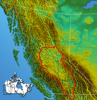
The Interior Plateau comprises a large region of the Interior of British Columbia, and lies between the Cariboo and Monashee Mountains on the east, and the Hazelton Mountains, Coast Mountains and Cascade Range on the west. The continuation of the plateau into the United States is known there as the Columbia Plateau.
The North American Cordillera is the North American portion of the American Cordillera which is a mountain chain (cordillera) along the western side of the Americas. The North American Cordillera covers an extensive area of mountain ranges, intermontane basins, and plateaus in western North America, including much of the territory west of the Great Plains. It is also sometimes called the Western Cordillera, the Western Cordillera of North America, or the Pacific Cordillera.
The Paleo-Arctic Tradition is the name given by archaeologists to the cultural tradition of the earliest well-documented human occupants of the North American Arctic, which date from the period 8000–5000 BC. The tradition covers Alaska and expands far into the east, west, and the Southwest Yukon Territory.
The Old Cordilleran Culture, also known as the Cascade phase, is an ancient culture of Native Americans that settled in the Pacific Northwestern region of North America that existed from 9000 or 10000 BC until about 5500 BC.

Blue Lake Crater is a maar, or a broad, low-relief volcanic crater, in the U.S. state of Oregon. Located in Jefferson County, it consists of three overlapping craters, which hold Blue Lake. The drainage basin for Blue Lake has very steep, forested slopes and is mostly part of the explosion crater left by the volcano's eruption. The volcano lies within the Metolius River basin, which supports a wide array of plant life, large and small mammals, and more than 80 bird species. In 2009, Governor of Oregon Ted Kulongoski signed a bill designating the Metolius River basin as an area of critical concern, preventing large-scale development on the land and protecting its wildlife.
The Oregon high desert is a region of the U.S. state of Oregon located east of the Cascade Range and south of the Blue Mountains, in the central and eastern parts of the state. Divided into a southern region and a northern region, the desert covers most of five Oregon counties and averages 4,000 feet (1,200 m) above sea level. The southwest region is part of the Great Basin and the southeast is the lower Owyhee River watershed. The northern region is part of the Columbia Plateau, where higher levels of rainfall allow the largest industry on private land to be the cultivation of alfalfa and hay. Public land within the region is owned primarily by the Bureau of Land Management, which manages more than 30,000 square miles (78,000 km2) including five rivers designated as Wild and Scenic.
Lake Mojave is an ancient former lake fed by the Mojave River that, through the Holocene, occupied the Silver Lake and Soda Lake basins in the Mojave Desert of San Bernardino County, California. Its outlet may have ultimately emptied into the Colorado River north of Blythe.
Dust Cave is a Paleoindian archaeology site located in northern Alabama. It is in the Highland Rim in the limestone bluffs that overlook Coffee Slough, a tributary of the Tennessee River. The site was occupied during the Pleistocene and early Holocene eras. 1LU496, another name for Dust Cave, was occupied seasonally for 7,000 years. The cave was first discovered in 1984 by Dr. Richard Cobb and first excavated in 1989 under Dr. Boyce Driskell from the University of Alabama.

Franktown Cave is located 25 miles south of Denver, Colorado on the north edge of the Palmer Divide. It is the largest rock shelter documented on the Palmer Divide, which contains artifacts from many prehistoric cultures. Prehistoric hunter-gatherers occupied Franktown Cave intermittently for 8000 years beginning about 6400 B.C. The site held remarkable lithic and ceramic artifacts, but it is better known for its perishable artifacts, including animal hides, wood, fiber and corn. Material goods were produced for their comfort, task-simplification and religious celebration. There is evidence of the site being a campsite or dwelling as recent as AD 1725.

The Archaic–Early Basketmaker Era was an Archaic cultural period of ancestors to the Ancient Pueblo People. They were distinguished from other Archaic people of the Southwest by their basketry which was used to gather and store food. They became reliant on wild seeds, grasses, nuts and fruit for food and changed their movement patterns and lifestyle by maximizing the edible wild food and small game within a geographical region. Manos and metates began to be used to process seeds and nuts. With the extinction of megafauna, hunters adapted their tools, using spears with smaller projectile points and then atlatl and darts. Simple dwellings made of wood, brush and earth provided shelter.
Chipped stone crescents are a class of artifact found mainly associated with surface components of archaeological sites located in the Great Basin, the Columbia Plateau, and throughout California. Although their distribution covers a large portion of the western United States, crescents are often found in similar contexts in close proximity to water sources including playas, lakes, rivers, and mainland and island coast lines. Crescents are generally thought to be diagnostic to the terminal Pleistocene and early Holocene and are representative of assemblages that include fluted and stemmed projectile points.
Neopluvial is a term referring to a phase of wetter and colder climate that occurred during the late Holocene in the Western United States. During the Neopluvial, water levels in a number of now-dry lakes and closed lakes such as the Great Salt Lake rose and vegetation changed in response to increased precipitation. The event was not exactly synchronous everywhere, with neopluvial lake-level rises occurring between 6,000 and 2,000 years ago. It is correlative to the Neoglacial period.
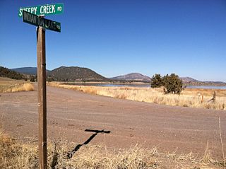
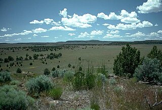
Archeological Site 4-SK-4, in Tulelake, California, near Macdoel, California, is a stratified archeological site that was a hunter-gatherer village on the west shores of the Lower Klamath Lake. The site is located in the heart of the Klamath Basin wetlands, west of Indian Tom Lake. It has also been known as Nightfire Island and as Sheepy Island. Modern Modocs have called the island Shapasheni, meaning "where the sun and moon live", or "home of the sun and the moon.
References
- ↑ Kipfer, B. A., "Encyclopedic Dictionary of Archaeology", Kluwer Academic/Plenum Publishers, NY 2000, p. 403
- ↑ Peregrine, P. N. and M. Ember, "Encyclopedia of Prehistory Volume 6: North America", Human Relations Area Files, Springer Pub., NY 2003, p. 28
- ↑ Cascade Points in the Northern Great Basin: A Radiocarbon-dated Foliate Point Assemblage from Warner Valley, Oregon. By GM Smith ; P Carey ; ES Middleton ; J Kielhofer