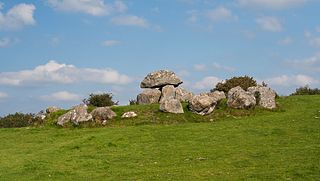
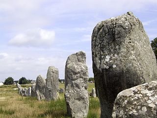
A stone row or stone alignment is a linear arrangement of megalithicstanding stones set at intervals along a common axis or series of axes, usually dating from the later Neolithic or Bronze Age.[1] Rows may be individual or grouped, and three or more aligned stones can constitute a row.
Part of the Kerlescan alignment in Carnac, Brittany
The term alignment is sometimes taken to imply that the rows were placed purposely in relation to other factors such as other monuments or topographical or astronomical features. Archaeologists treat stone rows as discrete features however and alignment refers to the stones being lined up with one another rather than anything else. Their purpose is thought to be religious or ceremonial perhaps marking a processional route. Another theory is that each generation would erect a new stone to contribute to a sequence that demonstrated a people's continual presence.
Stone rows can be few metres or several kilometres in length and made from stones that can be as tall as 2m, although 1m high stones are more common. The terminals of many rows have the largest stones and other megalithic features are sometimes sited at the ends, especially burial cairns. The stones are placed at intervals and may vary in height along the sequence, to provide a graduated appearance, though it is not known whether this was done deliberately. Stone rows were erected by the later Neolithic and Bronze Age peoples in the British Isles, parts of Scandinavia and northern France.
Ó Nualláin, Seán. "Stone Rows in the South of Ireland". Proceedings of the Royal Irish Academy: Archaeology, Culture, History, Literature, volume 88C, 1988. JSTOR25516044
Power, Denis. Archaeological inventory of County Cork, Volume 3: Mid Cork. Stationery Office, 1992. ISBN978-0-7076-4933-7
Lancaster Brown, P. (1976). Megaliths, myths, and men: an introduction to astro-archaeology. New York: Taplinger Pub. Co.
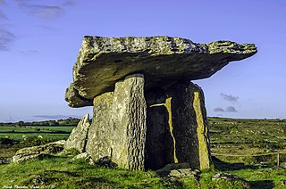
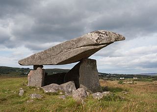
A dolmen or portal tomb is a type of single-chamber megalithic tomb, usually consisting of two or more upright megaliths supporting a large flat horizontal capstone or "table". Most date from the Late Neolithic period and were sometimes covered with earth or smaller stones to form a tumulus. Small pad-stones may be wedged between the cap and supporting stones to achieve a level appearance. In many instances, the covering has eroded away, leaving only the stone "skeleton".
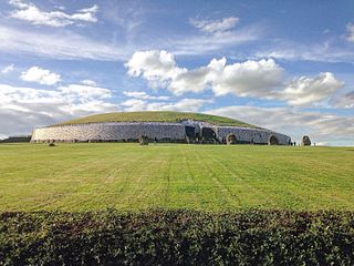
Newgrange is a prehistoric monument in County Meath in Ireland, located on a rise overlooking the River Boyne, 8 kilometres (5.0 mi) west of Drogheda. It is an exceptionally grand passage tomb built during the Neolithic Period, around 3200 BC, making it older than Stonehenge and the Egyptian pyramids. It is aligned on the winter solstice sunrise. Newgrange is the main monument in the Brú na Bóinne complex, a World Heritage Site that also includes the passage tombs of Knowth and Dowth, as well as other henges, burial mounds and standing stones.
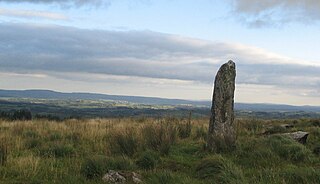
A menhir, standing stone, orthostat, or lith is a large upright stone, emplaced in the ground by humans, typically dating from the European middle Bronze Age. They can be found individually as monoliths, or as part of a group of similar stones. Menhirs' size can vary considerably, but they often taper toward the top.
A megalith is a large stone that has been used to construct a prehistoric structure or monument, either alone or together with other stones. There are over 35,000 in Europe alone, located widely from Sweden to the Mediterranean sea.
There are three related types of Neolithic earthwork that are all sometimes loosely called henges. The essential characteristic of all three is that they feature a ring-shaped bank and ditch, with the ditch inside the bank. Because the internal ditches would have served defensive purposes poorly, henges are not considered to have been defensive constructions. The three henge types are as follows, with the figure in brackets being the approximate diameter of the central flat area:
Henge. The word henge refers to a particular type of earthwork of the Neolithic period, typically consisting of a roughly circular or oval-shaped bank with an internal ditch surrounding a central flat area of more than 20 m (66 ft) in diameter. There is typically little if any evidence of occupation in a henge, although they may contain ritual structures such as stone circles, timber circles and coves. Henge monument is sometimes used as a synonym for henge. Henges sometimes, but by no means always, featured stone or timber circles, and circle henge is sometimes used to describe these structures. The three largest stone circles in Britain are each within a henge. Examples of henges without significant internal monuments are the three henges of Thornborough Henges. Although having given its name to the word henge, Stonehenge is atypical in that the ditch is outside the main earthwork bank.
Hengiform monument. Like an ordinary henge, except the central flat area is between 5 and 20 m (16–66 ft) in diameter, they comprise a modest earthwork with a fairly wide outer bank. The terms Mini henge or Dorchester henge are sometimes used as synonyms for hengiform monument. An example is the Neolithic site at Wormy Hillock Henge.
Henge enclosure. A Neolithic ring earthwork with the ditch inside the bank, with the central flat area having abundant evidence of occupation and usually being more than 300 m (980 ft) in diameter. Some true henges are as large as this, but lack evidence of domestic occupation. Super henge is sometimes used as a synonym for a henge enclosure. However, sometimes Super henge is used to indicate size alone rather than use, e.g. "Marden henge ... is the least understood of the four British 'superhenges' ".
A stone circle is a ring of standing stones. Most are found in Northwestern Europe – especially in Britain, Ireland, and Brittany – and typically date from the Late Neolithic and Early Bronze Age, with most being built from 3000 BC. The best known examples include those at the henge monument at Avebury, the Rollright Stones, and elements within the ring of standing stones at Stonehenge. Scattered examples exist from other parts of Europe. Later, during the Iron Age, stone circles were built in southern Scandinavia.
Beaghmore is a complex of early Bronze Age megalithic features, stone circles and cairns, 8.5 miles north west of Cookstown, County Tyrone in Northern Ireland, on the south-east edge of the Sperrin Mountains.
Carrowmore is a large group of megalithic monuments on the Coolera Peninsula to the west of Sligo, Ireland. They were built in the 4th millennium BC, during the Neolithic. There are thirty surviving tombs, making Carrowmore one of the largest clusters of megalithic tombs in Ireland, and one of the 'big four' along with Carrowkeel, Loughcrew and Brú na Bóinne. Carrowmore is the heart of an ancient ritual landscape which is dominated by the mountain of Knocknarea to the west. It is a protected National Monument.
Brú na Bóinne, also called the Boyne Valley tombs, is an ancient monument complex and ritual landscape in County Meath, Ireland, located in a bend of the River Boyne. It is one of the world's most important Neolithic landscapes, comprising at least ninety monuments including passage tombs, burial mounds, standing stones and enclosures. The site is dominated by the passage tombs of Newgrange, Knowth and Dowth, built during the 32nd century BC. Together these have the largest assemblage of megalithic art in Europe. The associated archaeological culture is called the "Boyne culture".
The Carnac stones are an exceptionally dense collection of megalithic sites near the south coast of Brittany in northwestern France, consisting of stone alignments (rows), dolmens, tumuli and single menhirs. More than 3,000 prehistoric standing stones were hewn from local granite and erected by the pre-Celtic people of Brittany and form the largest such collection in the world. Most of the stones are within the Breton municipality of Carnac, but some to the east are within neighboring La Trinité-sur-Mer. The stones were erected at some stage during the Neolithic period, probably around 3300 BC, but some may date to as early as 4500 BC.
Carrigagulla is a megalithic complex 2.9 km north-east of Ballinagree, County Cork, Ireland.
This article describes several characteristic architectural elements typical of European megalithic structures.
The Uragh Stone Circle is an axial five-stone circle located near Gleninchaquin Park, County Kerry, Ireland. The Bronze Age site includes a multiple stone circle and some boulder burials.
Kilclooney More is a townland in the northwest of Ireland in coastal County Donegal. It is situated halfway between Narin and Ardara at the R261 on the Loughrea Peninsula.
The stone circles in the British Isles and Brittany are a megalithic tradition of monuments consisting of standing stones arranged in rings. These were constructed from 3300 to 900 BCE in Britain, Ireland and Brittany. It has been estimated that around 4,000 of these monuments were originally constructed in this part of north-western Europe during this period. Around 1,300 of them are recorded, the others having been destroyed.
An axial stone circle is a megalithic ring of stones of a particular design found in County Cork and County Kerry in southwest Ireland. Archaeologists have found it convenient to consider the axial five-stone circle and axial multiple-stone circle separately. The circle has an approximate axis of symmetry aligned in a generally northeast–southwest direction. The stone at the southwest side of the circle, rather than being an upright orthostat like all the rest, is a slab lying horizontally with its long thin edge along the circumference of the ring. Because it marks the axis of the circle it is called the axial stone.
Kealkill stone circle is a Bronze Age axial five-stone circle located just outside the village of Kealkill, County Cork in southwest Ireland. When it was excavated in 1938 it was thought the crucial axial stone indicated an alignment to the north, contrary to the general alignment of such stone circles to the southwest. However, later archaeologists have thought it is the comparatively insignificant stone to the southwest that is the axial stone. There are two associated standing stones nearby, one of which had fallen and was re-erected in 1938.
Castlenalacht Stone Row is an alignment of four tall and free-standing stones located on a hilltop in the townland of Castlenalacht, Innishannon parish, 6km north of Bandon, County Cork, Ireland. It dates from the Bronze Age and is the largest of the over 80 stone rows in south-west Ireland.
This page is based on this Wikipedia article Text is available under the CC BY-SA 4.0 license; additional terms may apply. Images, videos and audio are available under their respective licenses.