Britain, Ireland, and the Channel Islands
Aubrey Burl's gazetteer lists 1,303 stone circles in Britain, Ireland and Brittany ( France). Most of these are found in Scotland, with 508 sites recorded. There are 343 on the island of Ireland; 316 in England; 81 in Wales; 49 in Brittany (France); and 6 in the Channel Isles. [1]
Channel Islands

Aubrey Burl records six sites in the Channel Islands, four on Guernsey and two on Jersey. All six are Cist-in-Circle monuments, which are influenced by chambered tomb design. Their relationship with the stone circle tradition of Britain, Ireland and Brittany is unclear. [2]
| Guernsey |  | Le Creux ès Faïes, cist-in-circle, semicircular stone wall supporting a mound containing a passage grave | 49°27′24″N2°39′21″W / 49.4566°N 2.6557°W |
| Photo see Megalith Guernsey [3] | Steinkiste von L’Islet (de), cist-in-circle, stone cist in a circle of irregularly shaped stones | 49°29′19″N2°32′41″W / 49.48865°N 2.5448°W | |
| | Les Fouillages (fr/de), a passage grave in a triangular enclosure of small irregularly shaped stones | 49°29′51″N2°32′16″W / 49.49747°N 2.53775°W | |
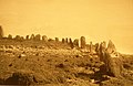
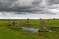
| Jersey |  | Ville-ès-Nouaux | 49°11′47″N2°07′50″W / 49.196389°N 2.130556°W |
England

South East England
There are no ancient stone circles in Kent [4] or Sussex.
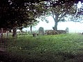
| Essex |  | The stones lying around the church of Alphamstone might be relics of a stone circle, [5] the only one on the peninsula between the Thames estuary and the Wash. [6] | 51°59′09″N0°44′05″E / 51.9858469°N 0.7347047°E |
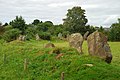
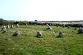
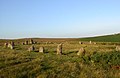
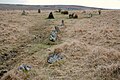
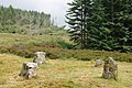
| Oxfordshire |  | The King's Men, one of three monuments that make up the Rollright Stones, found near the village of Long Compton | 51°58′32″N1°34′14″W / 51.97552°N 1.57068°W |
East Midlands
Derbyshire
 | Arbor Low, near Youlgreave | |
 | Barbrook One, on Ramsley Moor in the Peak District | SK27857558 . |
 | Doll Tor, near Birchover | |
 | Hordron Edge, on the edge of Moscar Moor | SK2152486851 . |
 | Nine Ladies, nine stones on Stanton Moor | |
 | Nine Stones Close, between Alport and Winster | SK225626 . |
Yorkshire and the Humber
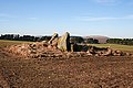
| North Yorkshire | | Fancarl Top stone circle, [7] near River Wharfe, circle of 5 stones and a central stone | HE 1008781 SE0642863048 54°03′48″N1°54′12″W / 54.063359°N 1.903242°W |
| no appropriate photo available | Healey Stone Circle [8] | SE170810 54°13′28″N1°44′27″E / 54.22444°N 1.740756°E | |
| no appropriate photo available | Cairnfield on Standingstones Rigg, including a cup and ring, [9] Cloughton Moor, Harwood Dale | HE 1019799 SE 98047 96859 , SE 98140 96989 54°21′32″N0°29′23″W / 54.358911°N 0.489729°W | |
 | High Bridestones [10] on Sleights Moor, Eskdaleside cum Ugglebarnby | HE 1004892 NZ8499904635 54°25′48″N0°41′29″W / 54.430055°N 0.691259°W | |
 | Yockenthwaite stone circle | HE 1008772 SD8995779376 54°12′36″N2°09′19″W / 54.209911°N 2.155160°W | |
| West Yorkshire |  | Twelve Apostles (of Yorkshire) | SE12614506 |
North East England
| County Durham | | Lune Head Stone Circle [11] | 54°34′44″N2°14′03″W / 54.57876°N 2.234037°W |
| Northumberland |  | Duddo Five Stones, 6 km (4 mi) south of the Scottish border, formerly known as the Four Stones | 55°41′12″N2°06′43″W / 55.68677°N 2.112023°W |
 | The Goatstones, a Bronze-age four-poster near the village of Wark on Tyne | 55°04′03″N2°16′09″W / 55.067372°N 2.269297°W | |
 | Threestoneburn Stone Circle, a circle of 16 stones in Threestoneburn Wood, near the village of Ilderton | 55°28′42″N2°02′49″W / 55.4783°N 2.04692°W |
North West England
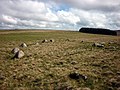
Cumbria
 | Birkrigg, two non-concentric circles, 3 km (2 mi) south of Ulverston | SD 29247396 |
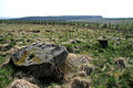
 | Brat's Hill, the largest of the Burnmoor stone circles, 1.6 km (1 mi) south of Boot | |
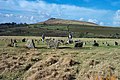
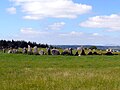
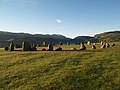 | Castlerigg, a 33-metre-diameter (108 ft) ring consisting of 38 stones | |
 | Gamelands, near Orton, Eden | NY640081 . |
 | Kinniside, a reconstructed stone circle of 11 stones | NY060140 . |
 | Long Meg and Her Daughters, about 51 stones set in an oval shape measuring 100 m (330 ft) on its long axis | |
 | Low Longrigg circles, two of the Burnmoor stone circles, 2 km (1 mi) south of Boot | |
 | Oddendale, part of the Shap Stone Avenue monuments | ( NY59201290 ). |
 | Swinside, a nearly perfect circle in Lake District | |
 | White Moss stone circles, two of the Burnmoor stone circles: 1.6 km (1 mi) south of Boot |
Lancashire
 | Cheetham Close, Bronze Age site on the moors of Egerton, Bolton. |
West Midlands
Shropshire
 | Mitchell's Fold, ring of 30 stones, 15 still standing |
Whetstone Circle , partial circle as stones removed for local building
Hoarstone Circle , utilised for local wedding celebrations
South West England
Cornwall
 | Boscawen-Un, stone circle with a leaning pillar in its interior. |
 | Boskednan, partially restored stone circle near Boskednan, about 6 kilometres (4 miles) northwest of the town of Penzance. |
 | Craddock Moor, near Minions on Bodmin Moor, 800 m (1⁄2 mi) northwest of The Hurlers. |
 | Duloe, in the village of Duloe, 8 km (5 mi) from Looe. |
 | Emblance Downs stone circles, a pair of circles in the parish of St. Breward on Bodmin Moor. |
 | Fernacre, on the slopes of the De Lank River, 2 km (1+1⁄4 mi) northeast of St Breward on Bodmin Moor. |
 | The Hurlers, a group of three stone circles on Bodmin Moor. |
 | The Merry Maidens, near St Buryan in West Penwith. |
 | Nine Stones, Altarnun, 3 km (2 mi) south southeast of Altarnun, 11 km (7 mi) west of Launceston on Bodmin Moor. |
 | Stannon, near St Breward on Bodmin Moor. |
 | Tregeseal East, also known as the Tregeseal Dancing Stones, near St Just in West Penwith. |
 | Trippet stones, Manor Common in Blisland, 9 km (5.6 mi) north northeast of Bodmin on Bodmin Moor. |
Devon
 | Brisworthy stone circle |
 | Grey Wethers stone circles |
 | Ringmoor Down |
 | Scorhill |
 | Shovel Down |
| Tottiford Reservoir | |
 | Yellowmead stone circle |
Dorset
 | Kingston Russell, an 18-stone Bronze Age circle near Abbotsbury. | 50°41′18.7″N2°35′56.2″W / 50.688528°N 2.598944°W |
 | Rempstone stone circle, a damaged stone circle near Corfe Castle in Dorset. It is located next to the B3351 road on the Isle of Purbeck | SY994820 . |
 | The Nine Stones, a small nine stone circle near Winterbourne Abbas |
Somerset
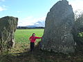
 | Stanton Drew, one of three circles located near the village of Stanton Drew. |
 | Withypool Stone Circle, on the Exmoor moorland, near the village of Withypool. Only the stones present on the two ends of the circle are visible. |
Wiltshire
| | Avebury, large stone circle surround the village of Avebury. |
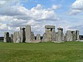 | Stonehenge, World Heritage site. |
Wales


Scotland

Southern Scotland
Argyll and Bute
 | Cultoon stone circle, Islay | NR19565697 . |
 | Ettrick Bay stone circle, Bute | NS0443466794 . |
 | Lochbuie stone circle, Mull | NM6178025117 . |
 | Temple Wood stone circles | NR82639782 . |
Dumfries and Galloway
Aubrey Burl lists 43 stone circles in Dumfries and Galloway: 15 in Dumfriesshire; 19 in Kirkcudbrightshire; and 9 in Wigtonshire. [12] The Royal Commission on the Ancient and Historical Monuments of Scotland records 49 stone circles in the region. Of these 49, 24 are listed as 'possible'; one is an 18th-century construction; and a number have been destroyed. [13]
| Image | Details | Grid Reference |
|---|---|---|
 | Easthill stone circle near Dumfries | NX9192873878 |
 | The Girdle Stanes near Eskdalemuir | NY2535196153 |
 | Glenquicken near Creetown | NX50965821 |
 | Lochmaben Stone just south of Gretna | |
 | The Loupin Stanes near Eskdalemuir | NY25709663 |
 | Seven Brethren near Lockerbie | NY21718269 |
 | Standing Stones of Glenterrow between Stranraer and New Luce | NX14536251 |
 | Twelve Apostles Stone Circle, situated between Holywood and Newbridge, near Dumfries. | |
| | Torhouskie | |
 | Whitcastles stone circle 10.5 km (6+1⁄2 mi) northeast of Lockerbie | NY 2240 8806 |
North Ayrshire
The Royal Commission on the Ancient and Historical Monuments of Scotland records 20 stone circles in North Ayrshire, all on Arran. [14] Five of these are listed as 'possible'. [14] Aubrey Burrel's gazetteer records 19 stone circles on Arran. [12]


Scottish Borders
– The List of stone circles in the Scottish Borders comprises in addition 8 stone circles not yet photographed for WM Commons. –
| The Royal Commission on the Ancient and Historical Monuments of Scotland records 16 stone circles in the Scottish Borders. Of these, three are marked as 'possible'. [15] Aubrey Burl's gazetteer lists the same number: 2 in Berwickshire; 2 in Peebleshire; 10 in Roxburghshire; and 2 in Selkirkshire. [12] | ||
 | Borrowston Rig, near Lauder | 55°45′44″N2°42′24″W / 55.762179°N 2.70658°W |
 | Burg Hill stones, near Teviothead | 55°20′50″N2°50′13″E / 55.347361°N 2.837066°E |
 | Cloyhouse Burn stone circle, classification not sure, between Stobo and Lyne | 55°38′06″N3°17′23″W / 55.63501°N 3.2898°W |
 | Five Stanes | NT75261686 |
 | Harestanes | NT12404432 |
 | Ninestane Rig | 55°16′03″N2°45′39″W / 55.26746°N 2.76091°W |
 | Yadlee stone circle, near Spott | 55°53′52″N2°33′17″E / 55.897796°N 2.554795°E |
North east Scotland
Aberdeen City
 | Tyrebagger stone circle | NJ 85950 13217 . |
Aberdeenshire
 | Aikey Brae stone circle | NJ 95873 47090 |
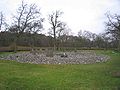
 | Cullerlie stone circle near Echt | |
| | Easter Aquhorthies recumbent stone circle, near Inverurie | |
 | Kirkton of Bourtie recumbent stone circle | NJ 80091 24883 . |
 | Hill of Fiddes recumbent stone circle | NJ 9350 2432 . |
 | Inschfield recumbent stone circle | NJ 6233 2934 . |
 | Loanhead of Daviot recumbent stone circle | |
 | Loudon Wood recumbent stone circle | NJ 96105 49740 . |
 | Midmar Kirk recumbent stone circle | NJ 69940 06493 . |
 | Old Keig stone circle | NJ 5965 1939 . |
 | New Craig recumbent stone circle | NJ 7455 2966 . |
 | The Nine Stanes | NO 7233 9122 . |
 | Potterton recumbent stone circle | NJ95291636 . |
 | South Ley Lodge recumbent stone circle | NJ76671325 . |
 | St Brandan's Stanes | NJ60756105 . |
 | Strichen stone circle | NJ9367454479 . |
 | Stonehead recumbent stone circle | NJ60102869 . |
 | Sunhoney | NJ7159205701 . |
 | Tillyfourie recumbent stone circle | NJ64311350 . |
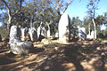
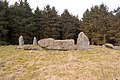
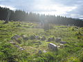
| | Tomnaverie recumbent stone circle, Aberdeenshire | |
Angus
 | Balkemback stone circle, Tealing | NO38183844 . |
 | Colmeallie stone circle | NO56567811 . |
Dundee
 | Balgarthno Stone Circle, Charleston, Dundee | NO3533031613 |
Fife
 | Balbirnie Stone Circle near Glenrothes | 56°12′50″N3°09′11″W / 56.21384°N 3.15293°W |
Perth and Kinros
 | Croft Moraig –6 km (4 mi) southwest of Aberfeldy, Scotland | NN79754726 |
Stirling
 | Killin – at the western end of Loch Tay | NN576327 . |
North West Scotland
Orkney
| There are two stone circles on Orkney, both on the Mainland. [16] The Royal Commission on the Ancient and Historical Monuments of Scotland records a possible third at Stoneyhill, also on the Mainland. [17] | ||
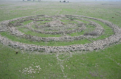
 | Ring of Brodgar – A 60 stone ring (27 still standing) | 59°00′05″N3°13′47″W / 59.0015°N 3.2297°W |
 | Standing Stones of Stenness | 58°59′38″N3°12′29″W / 58.9939°N 3.2081°W |
Shetland
| Aubrey Burl's gazetteer lists seven sites in Shetland, but notes that all are dubious. [18] The Royal Commission on the Ancient and Historical Monuments of Scotland records three stone circles. [19] It does not include Hjaltadans, which is instead categorised as a 'stone setting'. [20] | ||
 | Hjaltadans near Fetlar | 60°36′37″N0°51′56″W / 60.6102°N 0.86555°W |
Western Isles
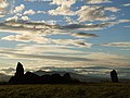
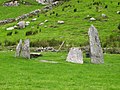
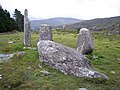
| Lewis |  | Callanish I | |
| | Callanish II Lewis, a smaller stone circle | ||
 | Callanish III Lewis, a smaller stone circle | ||
| | Callanish IV Lewis, a smaller stone circle | ||
 | Callanish VIII Lewis, a smaller stone semicircle | ||
| North Uist |  | Pobull Fhinn | NF8427465010 . |
Northern Ireland

| County | Photo | Notes |
|---|---|---|
| Down | 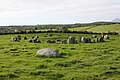 | Ballynoe stone circle |
| Fermanagh | 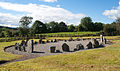 | Drumskinny stone circle |
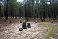
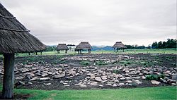
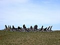
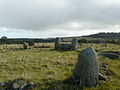
| Tyrone |  | Beaghmore – Located outside Cookstown. Seven circles, along with cairns and stone rows. One circle, known as the Dragon's Teeth, is filled with more than 800 small stones. |
Republic of Ireland

There are 187 stone circles in the Republic of Ireland. The vast majority of these are in County Cork, which has 103 circles. There are 20 circles in County Kerry and 11 in County Mayo. [12] There is also a large fully intact stone circle in Grange in County Limerick, near Lough Gur [21] Grange [22]
County Cork
 | Ardgroom SW –known locally as "Canfea", southwest of the village of Ardgroom on the Beara Peninsula. |
| Breeny More Stone Circle | |
 | Carrigagulla, about 18 stones, to the north of the village of Ballinagree. |
| Carrigaphooca stone circle, 3 stones, next to Carrigaphooca Castle. | |
 | Derreenataggart stone circle |
 | Drombeg stone circle, west of Rosscarbery. |
 | Kealkill stone circle, overlooking Bantry Bay. |
 | Knocknakilla, between Macroom and Millstreet. |
 | Glantane east, between Macroom and Millstreet. |
| | Templebryan Stone Circle, between Bandon and Millstreet. |
Donegal
 | Beltany stone circle |
Kerry
 | Kenmare stone circle |
 | Lissyvigeen stone circle |
 | Shronebirrane stone circle |
 | Uragh Stone Circle |
 | Cashelkeelty Stone Circles |