
A stone circle is a ring of standing stones. Most are found in Northwestern Europe – especially in Britain, Ireland, and Brittany – and typically date from the Late Neolithic and Early Bronze Age, with most being built from 3000 BC. The best known examples include those at the henge monument at Avebury, the Rollright Stones, and elements within the ring of standing stones at Stonehenge. Scattered examples exist from other parts of Europe. Later, during the Iron Age, stone circles were built in southern Scandinavia.
A cromlech is a megalithic construction made of large stone blocks. The word applies to two different megalithic forms in English, the first being an altar tomb, as William Borlase first denoted in 1769. A good example is at Carn Llechart. The second meaning of the name "cromlech" in English refers to large stone circles such as those found among the Carnac stones in Brittany, France.

Durrington Walls is the site of a large Neolithic settlement and later henge enclosure located in the Stonehenge World Heritage Site in England. It lies 2 miles (3.2 km) north-east of Stonehenge in the parish of Durrington, just north of Amesbury in Wiltshire. The henge is the second-largest Late Neolithic palisaded enclosure known in the United Kingdom, after Hindwell in Wales.

Carl Wark is a rocky promontory on Hathersage Moor in the Peak District National Park, just inside the boundary of Sheffield, England. The promontory is faced by vertical cliffs on all but one side, which is protected by a prehistoric embankment. The cliffs and embankment form an enclosure that has been interpreted as an Iron Age hill fort, though the date of construction and purpose of the fortifications remains unknown. The site is a scheduled monument.

The Grianan of Aileach, sometimes anglicised as Greenan Ely or Greenan Fort, is a hillfort atop the 244 metres (801 ft) high Greenan Mountain at Inishowen in County Donegal, Ireland. The main structure is a stone ringfort, thought to have been built by the Northern Uí Néill, in the sixth or seventh century CE; although there is evidence that the site had been in use before the fort was built. It has been identified as the seat of the Kingdom of Ailech and one of the royal sites of Gaelic Ireland. The wall is about 4.5 metres (15 ft) thick and 5 metres (16 ft) high. Inside it has three terraces, which are linked by steps, and two long passages within it. Originally, there would have been buildings inside the ringfort. Just outside it are the remains of a well and a tumulus.

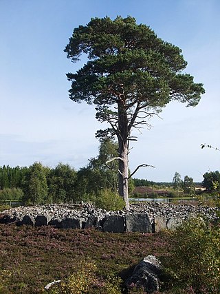
The Callanish Stones are an arrangement of standing stones placed in a cruciform pattern with a central stone circle, located on the Isle of Lewis, Scotland. They were erected in the late Neolithic era, and were a focus for ritual activity during the Bronze Age. They are near the village of Callanish on the west coast of Lewis in the Outer Hebrides, Scotland.

Dolni Glavanak is a village in the municipality of Madzharovo, in Haskovo Province, in southern Bulgaria.
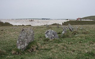
Stannon stone circle is a stone circle located near St. Breward on Bodmin Moor in Cornwall, England.

The Dolmen of Cunha Baixa is a dolmen in the civil parish of Cunha Baixa, in the municipality of Mangualde. It is located in a valley area of the Rio Castelo, between the villages of Cunha Baixa and Espinho.
The stone circles in the British Isles and Brittany are a megalithic tradition of monuments consisting of standing stones arranged in rings. These were constructed from 3300 to 900 BCE in Britain, Ireland and Brittany. It has been estimated that around 4,000 of these monuments were originally constructed in this part of north-western Europe during this period. Around 1,300 of them are recorded, the others having been destroyed.

Nordic megalith architecture is an ancient architectural style found in Northern Europe, especially Scandinavia and North Germany, that involves large slabs of stone arranged to form a structure. It emerged in northern Europe, predominantly between 3500 and 2800 BC. It was primarily a product of the Funnelbeaker culture. Between 1964 and 1974, Ewald Schuldt in Mecklenburg-Western Pomerania excavated over 100 sites of different types: simple dolmens, extended dolmens, passage graves, great dolmens, unchambered long barrows, and stone cists. In addition, there are polygonal dolmens and types that emerged later, for example, the Grabkiste and Röse. This nomenclature, which specifically derives from the German, is not used in Scandinavia where these sites are categorised by other, more general, terms, as dolmens, passage graves and stone cists.
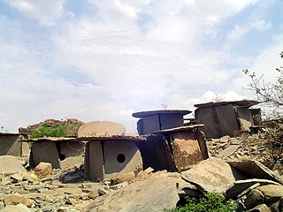
Hirebenakal or Hirébeṇakal or Hirébeṇakallu is a megalithic site in the state of Karnataka, India. It is among the few megalithic sites in India that can be dated to the 800 BCE to 200 BCE period. The site is located in the Koppal district, some 10 kilometres (6.2 mi) west of the town of Gangavati and some 35 kilometres (22 mi) from Hospet city. It contains roughly 400 megalithic funerary monuments, that have been dated to the transition period between Neolithic period and the Iron Age. Known locally as eḷu guḍḍagaḷu, their specific name is moryar guḍḍa. Hirebenakal is reported to be the largest necropolis among the 2000 odd megalithic sites found in South India, most of them in the state of Karnataka. Since 1955, it has been under the management of the Dharwad circle of the Archaeological Survey of India (ASI). On May 19, 2021, it was proposed that Hirebenakal be made a UNESCO World Heritage Site.

A ring cairn is a circular or slightly oval, ring-shaped, low embankment, several metres wide and from 8 to 20 metres in diameter. It is made of stone and earth and was originally empty in the centre. In several cases the middle of the ring was later used. The low profile of these cairns is not always possible to make out without conducting excavations.


Kingston Russell Stone Circle, also known as the Gorwell Circle, is a stone circle located between the villages of Abbotsbury and Littlebredy in the south-western English county of Dorset. Archaeologists believe that it was likely erected during the Bronze Age. The Kingston Russell ring is part of a tradition of stone circle construction that spread throughout much of Britain, Ireland, and Brittany during the Late Neolithic and Early Bronze Age, over a period between 3,300 and 900 BCE. The purpose of such monuments is unknown, although archaeologists speculate that they were likely religious sites, with the stones perhaps having supernatural associations for those who built the circles.

Porlock Stone Circle is a stone circle located on Exmoor, near the village of Porlock in the south-western English county of Somerset. The Porlock ring is part of a tradition of stone circle construction that spread throughout much of Britain, Ireland, and Brittany during the Late Neolithic and Early Bronze Age, over a period between 3300 and 900 BCE. The purpose of such monuments is unknown, although archaeologists speculate that the stones represented supernatural entities for the circles' builders.

The Nuragic sanctuary of Santa Vittoria is an archaeological site located in the municipality of Serri, Sardinia – Italy. The name refers to the Romanesque style church built over a place of Roman worship which rises at the westernmost tip of the site. The Santa Vittoria site was frequented starting from the first phase of the Nuragic civilization corresponding to Middle Bronze Age. Subsequently, from the late Bronze Age to the early Iron Age, the place became one of the most important expressions of the Nuragic civilization and today it constitutes the most important Nuragic complex so far excavated.

Castallack Round or Roundago is a prehistoric site near Castallack in Cornwall, England. It is a scheduled monument.

