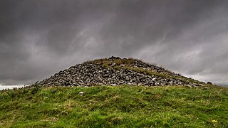
A chambered cairn is a burial monument, usually constructed during the Neolithic, consisting of a sizeable chamber around and over which a cairn of stones was constructed. Some chambered cairns are also passage-graves. They are found throughout Britain and Ireland, with the largest number in Scotland.

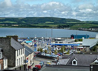
Dumfries and Galloway is one of the 32 unitary council areas of Scotland, located in the western part of the Southern Uplands. It is bordered by East Ayrshire, South Ayrshire, and South Lanarkshire to the north; Scottish Borders to the north-east; the English county of Cumbria, the Solway Firth, and the Irish Sea to the south, and the North Channel to the west. The administrative centre and largest settlement is the town of Dumfries. The second largest town is Stranraer, located 76 miles (122 km) to the west of Dumfries on the North Channel coast.
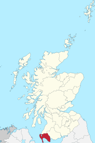
Wigtownshire or the County of Wigtown is one of the historic counties of Scotland, covering an area in the south-west of the country. Until 1975, Wigtownshire was an administrative county used for local government. Since 1975 the area has formed part of Dumfries and Galloway for local government purposes. Wigtownshire continues to be used as a territory for land registration, being a registration county. The historic county is all within the slightly larger Wigtown Area, which is one of the lieutenancy areas of Scotland and was used in local government as the Wigtown District from 1975 to 1996.

The court cairn or court tomb is a megalithic type of chambered cairn or gallery grave. During the period, 3900–3500 BC, more than 390 court cairns were built in Ireland and over 100 in southwest Scotland. The Neolithic monuments are identified by an uncovered courtyard connected to one or more roofed and partitioned burial chambers. Many monuments were built in multiple phases in both Ireland and Scotland and later re-used in the Early Bronze Age.

Glenluce is a small village in the parish of Old Luce in Wigtownshire, Scotland.

The Water of Luce is a river in Dumfries and Galloway, in south west Scotland.

The Standing Stones of Torhouse are a stone circle of nineteen granite boulders on the land of Torhouse, three miles west of Wigtown, Scotland.
Dunragit is a village on the A75, between Stranraer and Glenluce in Dumfries and Galloway, south-west Scotland. Dunragit is within the parish of Old Luce, in the traditional county of Wigtownshire. The modern village grew up around the west gate of Dunragit House, an 18th-century country house, though there is evidence of Neolithic settlement in the area.
Mochrum is a coastal civil and Church of Scotland parish situated to the east of Luce Bay on the Machars peninsula and 8 miles (13 km) southwest of Wigtown and in the historical county of Wigtownshire in Galloway, Scotland. It covers 22,000 acres (8,900 ha) and is approximately 10 miles (16 km) in length and 5 miles (8.0 km) in breadth. The parish contains the eponymous village of Mochrum, as well as Port William and the clachan of Elrig.
Glasserton is a civil parish in Dumfries and Galloway, south-west Scotland. It is on the Machars peninsula, in the traditional county of Wigtownshire. The parish is about 8 miles (13 km) in length, varying in breadth from 1 to 3 miles, and contains 13,477 acres (54.54 km2).

Kirkcowan is an area about 15 miles in length, and from nearly two to nearly seven miles in breadth, comprising 30,580 acres, of which 7000 are arable, 300 woodland and plantations, and the remainder meadow, pasture in Machars, in the historical county of Wigtownshire, in Dumfries and Galloway, Scotland, with the village of Kirkcowan, bounded on the east by the river Bladnoch, on the west by the river Tarff, and is 6 miles W. by S.W. from Newton Stewart.
Stoneykirk is an area and a village in the heart of the Rhins of Galloway, Wigtownshire, in the administrative council area of Dumfries and Galloway, Scotland nearly 10 miles (16 km) in length and 3+1⁄2 miles (5.6 km) in breadth, bounded on the east by the bay of Luce, and on the west by the Irish Channel, 5 miles (8 km) south of Stranraer.
Inch is a civil parish in Dumfries and Galloway, southwest Scotland. It lies on the shore of Loch Ryan, in the traditional county of Wigtownshire.
Old Luce is a civil parish in Dumfries and Galloway, Scotland. It lies in the Machars peninsula, in the traditional county of Wigtownshire. The parish is around 10 miles (16 km) long and 8 miles (13 km) broad, and contains 40,350 acres (16,330 ha).

Cairnholy is the site of two Neolithic chambered tombs of the Clyde type. It is located 4 kilometres east of the village of Carsluith in Dumfries and Galloway, Scotland. The tombs are scheduled monuments in the care of Historic Scotland.
Lagafater is a 7000-acre former sporting estate near New Luce in Dumfries and Galloway, Scotland. Since 1910 it has been in the family of its present owner, Sir Nicholas Spicer, Bt.

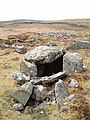
Bargrennan chambered cairns are a class of prehistoric chambered cairns found only in south-west Scotland, in western Dumfries and Galloway and southern Ayrshire. They form a separate group from the Clyde cairns which are found along the coast of western Britain. Unlike Clyde cairns, Bargrennan monuments are passage graves, with one or more chambers set into a round cairn. As well as being structurally different, Bargrennan cairns are separated from Clyde cairns by their siting and distribution; they are found in upland, inland areas of Galloway and Ayrshire. Murray suggests that there are around twelve Bargrennan monuments in south-west Scotland. She also notes that as sheep rees are often built into and over these types of cairns, more are likely to have been lost under shepherd's buildings.
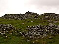
Mid Gleniron is a prehistoric site in Dumfries and Galloway used in the Neolithic and Bronze Age. The site is a scheduled ancient monument that comprises a group of six burial cairns. Two of the cairns, Mid Gleniron I and Mid Gleniron II are chambered cairns of the Clyde tradition. These are of historic importance because of their multi-stage construction which provides evidence for the development of Clyde cairns at the beginning of the Neolithic period.
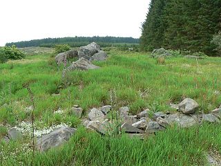
Cairnderry chambered cairn is a chambered cairn in Dumfries and Galloway. It is a Bargrennan cairn, a type of Neolithic or early Bronze Age monument only found in south west Scotland.