Balmaclellan

Last updated

Balmaclellan
'Old Mortality', Balmaclellan - geograph.org.uk - 680186.jpg
Balmaclellan
Dumfries and Galloway UK location map.svg
Red pog.svg
Balmaclellan
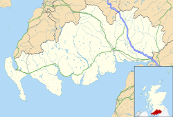
Location within Dumfries and Galloway
OS grid reference NX653791
Council area
Lieutenancy area
Country Scotland
Sovereign state United Kingdom
Post town CASTLE DOUGLAS
Postcode district DG7
Police Scotland
Fire Scottish
Ambulance Scottish
UK Parliament
Scottish Parliament
List of places
UK
Scotland
55°05′18″N04°06′46″W / 55.08833°N 4.11278°W / 55.08833; -4.11278

Balmaclellan (Scottish Gaelic: Baile Mac-a-ghille-dhiolan, [1] meaning town of the MacLellans) is a small hillside village of stone houses with slate roofs in a fold of the Galloway hills in south-west Scotland. To the west, across the Ken River, the larger and more prosperous New Galloway lies below the Rhinns of Kells.

Contents

Location and people

Balmaclellan is one of four parishes in the northern district of the Stewartry of Kirkcudbright. It contains 23,737 acres (96.1 km2), of which about 4,000 acres (16 km2) are cultivated. It includes areas of water, extensive plains of moss and about 300 acres (1.2 km2) of tree plantation, but most of the land is used for sheep or cattle pasture. Many of the cattle are of the Galloway breed. [2] The climate is temperate. Average monthly temperatures range from 1 to 7 °C (34 to 45 °F) in January, and 11 to 18 °C (52 to 64 °F) in July–August, with 984 mm (38.7 in) of rain yearly. [3]

In 1887, John Bartholomew's "Gazetteer of the British Isles" Described the inhabitants as "... of a mixed Gaelic and Germanic origin, and speak Braid Scots, a Northumbrian dialect of English. Those that profess a religion are generally but by no means entirely Calvinist Christians, adhering to the Church of Scotland or the Wee Frees". [4] In 2009, of those who profess a religion in Balmaclellan most are Presbyterians adhering to the Church of Scotland.

The population was 554 in 1801, 634 in 1901 and 550 in 1951. [4]

History

Celtic relics have been found in the area, including a finely decorated mirror and crescent of the Bronze Age that is now in the National Museum of Scotland. The parish of Balmaclellan appears to have had an earlier British name, Treuercarcou, which appears in a thirteenth-century record of ecclesiastical taxes. The treu- part of this name is clearly the old northern British equivalent of modern Welsh tref, 'farmstead, dwelling', and car- is likely derived from caer meaning 'hill-fort', indicating an early settlement when this P-Celtic language was still spoken in the area.

The upper village has a 12th-century motte: the "Bal" of Balmaclellan. Barscobe Castle is just over a mile to the northeast, built in 1648 by William Maclellan, a fine example of the last phase of tower house building in Scotland. [5]

Balmaclellan Parish Church was built in 1753 and added to in 1833 by local architect William McCandlish.

Balmaclellan was once a centre of the Covenanter religious movement. The village has a statue to Robert Paterson, Sir Walter Scott's 'Old Mortality'. His wife Elizabeth Gray established a school in the village, which can still be seen. She died in 1785 and is buried in the churchyard. Amongst other gravestones is that of another Covenanter, Robert Grierson, who was killed for his faith in 1685 (not to be confused with Sir Robert Grierson of Lag, notorious persecutor of the Galloway Covenanters). [6]

The churchyard also contains what is probably the earliest civic war memorial in Scotland. It commemorates five men from Balmaclellan who died in the Crimean War.

They are:

A sixth man John Henry Upton Spalding Lt. RN., an officer who died at Sebastopol, is commemorated on his family's tombstone but not on the memorial itself. [7]

Near the edge of the Balmaclellan churchyard there is a rough uninscribed whinstone pillar that looks like an ancient monument, and is locally said to mark the grave of a witch. [8] Possibly the grave is that of Elspeth McEwen from nearby Dalry, who was found guilty of being a witch on her own confession and on the evidence of witnesses, and burned to death at Kirkcudbright in 1698. She was one of the last "witches" to be executed in Scotland. [9]

To the south of the village, on the north bank of the Shimmers Burn, lies Ironmacannie Mill, a Category A listed watermill, which has been converted into a holiday cottage. [10] [11]

Literary References

The Scots comedy, Torwatletie (1940), by playwright Robert McLellan, set during the Jacobite rising of 1715, depicts the household of a nominally fictional Laird of the district.

William Le Queux's novels The Czar's Spy (1905) and The Place of Dragons (1916) have scenes set in the area. [12]

Notable people

Related Research Articles

<span class="mw-page-title-main">Dumfries and Galloway</span> Council area of Scotland

Dumfries and Galloway is one of the 32 unitary council areas of Scotland, located in the western part of the Southern Uplands. It is bordered by East Ayrshire, South Ayrshire, and South Lanarkshire to the north; Scottish Borders to the north-east; the English ceremonial county of Cumbria, the Solway Firth, and the Irish Sea to the south, and the North Channel to the west. The administrative centre and largest settlement is the town of Dumfries. The second largest town is Stranraer, located 76 miles (122 km) to the west of Dumfries on the North Channel coast.

<span class="mw-page-title-main">Kirkcudbright</span> Human settlement in Scotland

Kirkcudbright is a town, parish and a royal burgh from 1455 in Kirkcudbrightshire, of which it is traditionally the county town, within Dumfries and Galloway, Scotland.

<span class="mw-page-title-main">Kirkcudbrightshire</span> Historic county in Scotland

Kirkcudbrightshire, or the County of Kirkcudbright or the Stewartry of Kirkcudbright is one of the historic counties of Scotland, covering an area in the south-west of the country. Until 1975, Kirkcudbrightshire was an administrative county used for local government. Since 1975, the area has formed part of Dumfries and Galloway for local government purposes. Kirkcudbrightshire continues to be used as a registration county for land registration. A lower-tier district called Stewartry covered the majority of the historic county from 1975 to 1996. The area of Stewartry district is still used as a lieutenancy area. Dumfries and Galloway Council also has a Stewartry area committee.

<span class="mw-page-title-main">Lord Kirkcudbright</span> Scottish peerage

Lord Kirkcudbright was a title in the Peerage of Scotland. It was created for Sir Robert Maclellan of Bombie on a 1633 royal visit to Scotland by King Charles I of England. Maclellan had already been created a baronet of Nova Scotia in 1631.

<span class="mw-page-title-main">New Galloway</span> Human settlement in Scotland

New Galloway is a town in the historical county of Kirkcudbrightshire in Dumfries and Galloway. It lies on the west side of the valley of the Water of Ken, 1 mile north of the end of Loch Ken. Before the local government reform of 1975, it was the smallest Royal Burgh in Scotland.

<span class="mw-page-title-main">Sir Robert Grierson, 1st Baronet</span> Scottish nobleman who persecuted Presbyterians in the 17th century

Sir Robert Grierson, 1st Baronet of Lag was a Scottish baronet from Dumfriesshire.

<span class="mw-page-title-main">Clan MacLellan</span> Lowland Scottish clan

The Clan MacLellan is a Scottish clan of the Scottish Lowlands. The clan does not currently have a chief therefore it is considered an Armigerous clan.

<span class="mw-page-title-main">Carsphairn</span> Village in Dumfries and Galloway, Scotland

Carsphairn is a village in the historic county of Kirkcudbrightshire in Dumfries and Galloway, Scotland. It is located about halfway between Dalmellington and St John's Town of Dalry, on the A713 road. Carsphairn annual sheep show is held in the village. Cairnsmore of Carsphairn is to the north east of the village in the Carsphairn and Scaur Hills. To the west is the ridge of the Rhinns of Kells in the Galloway Hills.

<span class="mw-page-title-main">Borgue, Dumfries and Galloway</span> Human settlement in Scotland

Borgue is a village and parish in the Stewartry of Kirkcudbright in Dumfries and Galloway, Scotland. It lies 5 miles south-west of Kirkcudbright and 6 miles south of Gatehouse of Fleet. The name Borgue is from Old Norse borg 'stronghold'.

<span class="mw-page-title-main">Crossmichael</span> Human settlement in Scotland

Crossmichael is a small village on the east side of Loch Ken in the historical county of Kirkcudbrightshire, about 4 miles (6.4 km) north of Castle Douglas in Scotland.

<span class="mw-page-title-main">Dunscore</span> Human settlement in Scotland

Dunscore is a small village which lies 9 miles (14 km) northwest of Dumfries on the B729, in Dumfriesshire, in the District Council Region of Dumfries and Galloway, southwest Scotland.

<span class="mw-page-title-main">Barscobe Castle</span> Seventeenth-century tower house in Balmaclellan, Kirkcudbrightshire, Scotland

Barscobe Castle is a 17th-century tower house in Balmaclellan, Kirkcudbrightshire, Scotland. It is a typical house of a country laird, and according to a panel above the entrance, was built in 1648. The L-plan tower was constructed using stone taken from Threave Castle. The main block is three storeys high with the stair wing one storey higher. The gables have a modification of crowsteps found only in Galloway. It is a fine example of a mid-17th-century house which was unoccupied for many years until 1971 when it was restored. It has a modern byre (barn) attached, which has been converted into a garage. Barscobe Castle is a category A listed building.

<span class="mw-page-title-main">Dalgarnock</span> Human settlement in Scotland

Dalgarnock, Dalgarno, Dalgarnoc was an ancient parish and a once considerable sized village in the Nithsdale area of Dumfries and Galloway, Scotland, south of Sanquhar and north of Dumfries that enclosed the parish of Closeburn but was annexed to Closeburn in 1606 following the Reformation, separated again in 1648 and finally re-united in 1697, as part of the process that established the Presbyterian Church of Scotland. It was a burgh of regality bordering the River Nith and Cample Water and held a popular market-tryst or fair from medieval times until 1601 when the Earl of Queensberry had them transferred to Thornhill, commemorated in song by Robert Burns, shortly before its demise and now only a remote churchyard remains at a once busy site.

<span class="mw-page-title-main">Kirkbride, Durisdeer</span> Human settlement in Scotland

Kirkbride, previously Kilbride was an ancient parish close to the village of Enterkinfoot, the lands of which lay on both sides of the River Nith in the old Strathnith area of Dumfries and Galloway, Scotland, about 5 miles south of Sanquhar and north of Closeburn. The parish was suppressed and divided between Durisdeer and Sanquhar parishes in 1732. The ruins of the kirk are a scheduled monument and the surrounding graveyard is a Category B listed building with the River Nith in the valley below. The Ha Cleuch Burn flows through the glen that lies to the east of the site with a lane reaching it that runs up from Enterkinfoot, ending at Coshogle Farm.

<span class="mw-page-title-main">Kirkandrews, Dumfries and Galloway</span> Hamlet in Dumfries and Galloway, Scotland

Kirkandrews, sometimes written as Kirkanders in older documents, is a coastal hamlet about 9 kilometres (6 mi) west-southwest of Kirkcudbright in Dumfries and Galloway, Scotland. It sits in farmland at the head of Kirkandrews Bay, an inlet of Wigtown Bay.

<span class="mw-page-title-main">Kirkcudbright Tolbooth</span> Historic municipal building in Scotland

Kirkcudbright Tolbooth is a historic municipal building in Kirkcudbright in Kirkcudbrightshire in the administrative area of Dumfries and Galloway, Scotland. Built between 1627 and 1629 to serve the town as a centre of commercial administration, a meeting place for the council, and a prison, it was used for all these roles until the late eighteenth century when the council moved much of its business to new, larger premises they had constructed across the street; the tolbooth remained in use as a prison until the early nineteenth century, after which it remained in council ownership and was put to a variety of uses.

Elspeth McEwen or McKewan or Elizabeth MacEwan of Balmaclellan was the most famous convicted witch in Galloway and the last to be burnt at the stake there.

<span class="mw-page-title-main">Kirkcudbright war memorial</span> War memorial in Kirkcudbright, Scotland, UK

Kirkcudbright war memorial commemorates the men of the Scottish town of Kirkcudbright killed during the First and Second World Wars. It is situated in front of the 16th-century MacLellan's Castle and shows a seated warrior with sword and shield with a sleeping child on his knee. The memorial was designed by George Henry Paulin and erected in 1921 to commemorate the men lost during the First World War. Additional plaques were added following the Second World War.

References

  1. Lower, Mark Antony (1860). Patronymica Britannica: A Dictionary of The Family Names of The United Kingdom. London and Lewes: John Russell Smith and G. P. Bacon. p.  209 . Retrieved 2 November 2022.
  2. "Gen Uki.org: Balmaclellan". Archived from the original on 6 July 2008. Retrieved 18 November 2008.
  3. "Met Office Auchincruive 1971-2000 averages". Archived from the original on 24 October 2008. Retrieved 19 November 2008.
  4. 1 2 "A vision of Balmaclellan". Archived from the original on 24 October 2012. Retrieved 18 November 2008.
  5. "Overview of Balmaclellan - Dumfries and Galloway". Archived from the original on 22 September 2012. Retrieved 11 November 2010.
  6. "Visit Southern Scotland.com: Balmaclellan". Archived from the original on 25 May 2007. Retrieved 18 November 2008.
  7. "Balmaclellan Crimean War". Archived from the original on 26 October 2018. Retrieved 25 October 2018.
  8. "Balmaclellan Archaeology Notes". Archived from the original on 2 May 2022. Retrieved 18 November 2008.
  9. "A Witch's Execution". Archived from the original on 9 June 2011. Retrieved 18 November 2008.
  10. "About". The Hidden Mill. Archived from the original on 18 April 2022. Retrieved 9 April 2022.
  11. Historic Environment Scotland. "Ironmacannie Mill (Category A Listed Building) (LB3315)" . Retrieved 9 April 2022.
  12. Rimington, Stella (11 January 2011). "John Buchan and The Thirty-Nine Steps". Daily Telegraph. ISSN   0307-1235. Archived from the original on 23 September 2019. Retrieved 4 October 2019.