Dumfries is a market town and former royal burgh in Dumfries and Galloway, Scotland, near the mouth of the River Nith on the Solway Firth, 25 miles (40 km) from the Anglo-Scottish border. Dumfries is the county town of the historic county of Dumfriesshire.

Dumfries and Galloway is one of the 32 unitary council areas of Scotland, located in the western part of the Southern Uplands. It is bordered by East Ayrshire, South Ayrshire, and South Lanarkshire to the north; Scottish Borders to the north-east; the English county of Cumbria, the Solway Firth, and the Irish Sea to the south, and the North Channel to the west. The administrative centre and largest settlement is the town of Dumfries. The second largest town is Stranraer, located 76 miles (122 km) to the west of Dumfries on the North Channel coast.

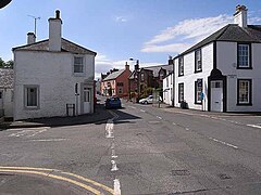
Thornhill is a village in the Mid Nithsdale area of Dumfries and Galloway, Scotland, south of Sanquhar and north of Dumfries on the main A76 road. Thornhill sits in the Nithsdale valley with the Carsphairn and Scaur range to the west and the Lowther hills to the east. It was initially a small village, planned and built in 1717 on the Queensberry Estate on the road linking Dumfries to Glasgow. The Earl of Queensberry initially named the village 'New Dalgarnock' however the name did not achieve popular approval.

Dumfriesshire or the County of Dumfries or Shire of Dumfries is a historic county and registration county in southern Scotland. The Dumfries lieutenancy area covers a similar area to the historic county.

Nithsdale, also known as Strathnith, Stranith or Stranit, is the strath or dale of the River Nith in southern Scotland. Nithsdale was one of the medieval provinces of Scotland. The provinces gradually lost their administrative importance to the shires created from the twelfth century, with Nithsdale forming part of Dumfriesshire. A Nithsdale district covering a similar area to the medieval province was created in 1975, based in the area's main town of Dumfries. The district was abolished in 1996, since when the area has been directly administered by Dumfries and Galloway Council.

Scaur Water is a river which rises near Polskeoch in the Scaur hills in the region of Dumfries and Galloway, Scotland.

Shinnel Water, also spelt Shinnell, is a river in the region of Dumfries and Galloway, Scotland.
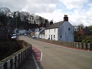
Carronbridge is a village in the parish of Morton in Dumfries and Galloway, Scotland. The village is at the junction of the A76 and A702 roads approximately 1 mile (2 km) north of Thornhill. The hamlet of Enterkinfoot lies slightly to the north. To the west of the village the Carron Water flows into the River Nith. Carronbridge Sawmill is in the village and is a Category B listed building built in the 1850s for the Duke of Buccleuch's Drumlanrig estate.
Mochrum is a coastal civil and Church of Scotland parish situated to the east of Luce Bay on the Machars peninsula and 8 miles (13 km) southwest of Wigtown and in the historical county of Wigtownshire in Galloway, Scotland. It covers 22,000 acres (8,900 ha) and is approximately 10 miles (16 km) in length and 5 miles (8.0 km) in breadth. The parish contains the eponymous village of Mochrum, as well as Port William and the clachan of Elrig.

Dunscore is a small village which lies 9 miles (14 km) northwest of Dumfries on the B729, in Dumfriesshire, in the District Council Region of Dumfries and Galloway, southwest Scotland.
Tynron Doon is a multivallate Iron Age hill fort outside the village of Tynron in Dumfries and Galloway, Scotland. It was occupied on and off from the 1st millennium BC until the 16th century, when an L-shaped tower house stood there. Tynron Doon lies at the southern end of the Scaur hills.

Tynron is a village and civil parish in Dumfries and Galloway, south-west Scotland, lying in a hollow of the Shinnel Water, 2 miles (3.2 km) from Moniaive.

The Lowther Hills, also sometimes known as the Lowthers, are an extensive area of hill country in the Southern Uplands of Scotland, though some sub-ranges of hills in this area also go under their own local names - see "Hillwalking" below. They form a roughly rhomboidal or lozenge shape on the map with the acute angles being to north and south. It has river valleys along its boundaries to north east (Clydesdale) and south west (Nithsdale) which carry the two largest arterial routes northwards into the west side of the Central Belt of Scotland. A string of small towns have long since developed along these routes. Most of the Lowther Hills lie in the Administrative County of Dumfries and Galloway, though part in the administrative county of South Lanarkshire moves into them around the village of Leadhills and the Daer Reservoir.

The Carsphairn and Scaur Hills are the western and eastern hills respectively of a hill range in the Southern Uplands of Scotland. Ordnance Survey maps don't have a general name for the hill area as a whole. Also, Ordnance Survey use "Scar" rather than the local spelling of "Scaur" - the word is pronounced as "Scar" however. In their Landranger Series of maps, it requires four separate sheets to cover the area.
Glencairn is an ecclesiastical and civil parish in Dumfries and Galloway, Scotland.

Cairn Water is a small river in Dumfries and Galloway, Scotland. The river, formed by the confluence of the Castlefern, Craigdarroch and Dalquhat, flows for 11.5 miles (18.5 km) southeast to the Cluden.

Dalgarnock, Dalgarno, Dalgarnoc was an ancient parish and a once considerable sized village in the Nithsdale area of Dumfries and Galloway, Scotland, south of Sanquhar and north of Dumfries that enclosed the parish of Closeburn but was annexed to Closeburn in 1606 following the Reformation, separated again in 1648 and finally re-united in 1697, as part of the process that established the Presbyterian Church of Scotland. It was a burgh of regality bordering the River Nith and Cample Water and held a popular market-tryst or fair from medieval times until 1601 when the Earl of Queensberry had them transferred to Thornhill, commemorated in song by Robert Burns, shortly before its demise and now only a remote churchyard remains at a once busy site.
Barburgh Mill is a hamlet composed of an old lint mill, later extended as a woollen mill and associated buildings which lies north of Auldgirth on the A76 on the route to Closeburn, in Dumfriesshire, Closeburn Parish, in Dumfries and Galloway, south-west Scotland. Its original nucleus was the old mill with associated buildings, the smithy, toll house and the miller's and workers dwellings. The site features the A76 that runs nearby, the River Nith and the Lake Burn that once powered the mill via a lade before joining the Nith. The area is famous for its association with the Covenanters. A Roman fortlet stood opposite the mill and a Roman road is thought to have run through Nithsdale at this point.

Kirkbride, previously Kilbride was an ancient parish close to the village of Enterkinfoot, the lands of which lay on both sides of the River Nith in the old Strathnith area of Dumfries and Galloway, Scotland, about 5 miles south of Sanquhar and north of Closeburn. The parish was suppressed and divided between Durisdeer and Sanquhar parishes in 1732. The ruins of the kirk are a scheduled monument and the surrounding graveyard is a Category B listed building with the River Nith in the valley below. The Ha Cleuch Burn flows through the glen that lies to the east of the site with a lane reaching it that runs up from Enterkinfoot, ending at Coshogle Farm.