Southern Uplands

Last updated

Southern Uplands and other geographical areas of Scotland Scotland (Location) Named (HR).png
Southern Uplands and other geographical areas of Scotland
The hills around Durisdeer from the A702 road Scotland Southern Uplands01 2002-08-16.jpg
The hills around Durisdeer from the A702 road
Looking east across Nithsdale to the Lowther Hills - from Cairnkinna in the Scaur Hills Lowther Hills from Cairnkinna.jpg
Looking east across Nithsdale to the Lowther Hills – from Cairnkinna in the Scaur Hills
Grey Mare's Tail in the Moffat Hills from the Bodesbeck Ridge in the Ettrick Hills Grey Mare's Tail Moffat Hills.jpg
Grey Mare's Tail in the Moffat Hills from the Bodesbeck Ridge in the Ettrick Hills
Source of the River Clyde where the Daer Water meets the Potrail Water Source of the River Clyde.JPG
Source of the River Clyde where the Daer Water meets the Potrail Water
From Hart Fell looking west to the Devil's Beef Tub. Devil's Beef Tub Moffat Hills.jpg
From Hart Fell looking west to the Devil's Beef Tub.
Loch Skene to Mid Craig and White Coomb from Lochcraig Head. Loch Skene Winter.jpg
Loch Skene to Mid Craig and White Coomb from Lochcraig Head.
Rhinns of Kells Range from the Carsphairn Hills Rhinns of Kells Range from Cairnsmore of Carsphairn Hills.jpg
Rhinns of Kells Range from the Carsphairn Hills
01 Dungeon Hill - 02 Merrick - 03 Little Spear of Merrick - 04 Kirriereoch - 05 Mullwharchar - 06 Tarfessock - 07 Shalloch on Minnoch - 08 Hoodens Hill. Dungeon Hills and Awful Hand from the Saddle between Millfire and Corserine.jpg
01 Dungeon Hill – 02 Merrick – 03 Little Spear of Merrick – 04 Kirriereoch – 05 Mullwharchar – 06 Tarfessock – 07 Shalloch on Minnoch – 08 Hoodens Hill.
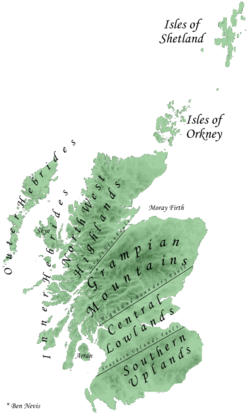
The Southern Uplands (Scottish Gaelic : Na Monaidhean a Deas) are the southernmost and least populous of mainland Scotland's three major geographic areas (the others being the Central Lowlands and the Highlands). The term is used both to describe the geographical region and to collectively denote the various ranges of hills and mountains within this region. An overwhelmingly rural and agricultural region, the Southern Uplands are partly forested and contain many areas of open moorland - the hill names in the area are congruent with these characteristics.

Contents

Geology

The Southern Uplands consist mainly of Silurian sedimentary deposits deposited in the Iapetus Ocean 420 million years ago. [1] These rocks were pushed up from the sea bed into an accretionary wedge during the Caledonian orogeny, roughly 400 million years ago (Ma), when the continents and terranes of Laurentia, Baltica and Avalonia collided. The Caledonian orogeny is named for Caledonia, a Latin name for Scotland. The majority of the rocks are weakly metamorphosed coarse greywacke. [2]

The tectonic processes involved in the formation of the accretionary wedge, where sediment is scraped off the seafloor as a tectonic plate is subducted, has led to the formation of multiple, major, east–west faults that are now exploited by rivers and define valleys across the Southern Uplands. Levels of deformation associated with these faults is highly variable but is pervasive in the finer-grained sediments. Secondary mineralisation has further altered these Lower Palaeozoic rocks which are hosts for some distinctive springs, some of which have been exploited for tourism, such as those around Moffat. [3]

Geography

The Southern Uplands lie south of the Southern Uplands Fault line that runs from Ballantrae on the Ayrshire coast northeastwards to Dunbar in East Lothian on the North Sea coast, a distance of some 220 km (140 mi). [4] [5] [6]

Hill ranges

There are several ranges of hills and mountains within the Southern Uplands. From east to west these are:

Peaks

Although the summits are not as high as many in the Scottish Highlands nor other famous mountain regions, parts of the Southern Uplands are remote and mountainous, containing about 120 Marilyns, the majority of the Donalds and a substantial number of Corbetts and Grahams.

Some of the more notable peaks in the Southern Uplands are:

The Southern Uplands are home to the UK's second highest, and Scotland's highest, village, Wanlockhead, 430 m (1,410 ft) above sea level. [6]

Rivers and lochs

The region is drained by numerous rivers, the most important of which are Scotland's third and fourth longest, the River Clyde at 106 mi (171 km) and the River Tweed at 97 mi (156 km) respectively. Several significant rivers drain southwards into the Solway Firth and Irish Sea including (from west to east) the River Cree, River Dee, River Urr, River Nith, River Annan and the River Esk. [14]

There are numerous lochs in the Southern Uplands, particularly in the west. The largest is Loch Ken the water lever of the loch was increased in 1936 when the Glenlochar Barrage was installed on the River Dee as well the Water of Ken was dammed to create manmade lochs as part of the Galloway Hydro Scheme. Several other lochs in Galloway are dammed such as Loch Doon, Loch Bradan and Clatteringshaws Loch though many smaller ones remain in a more natural state such as Loch Dee, Loch Enoch, Loch Grannoch and Loch Trool.

To the east of Moffat is the largest natural body of water in the Borders Region of the Southern Uplands, St. Mary's Loch together with the adjacent Loch of the Lowes and nearby Loch Skeen. There are several other reservoirs in the vicinity including Megget Reservoir, Talla Reservoir and Fruid Reservoir whilst Daer Reservoir lies among the Lowther Hills. [15]

Wildlife

The area has a wide diversity of species and habitats. The uplands support black and red grouse, mountain hares, golden eagles, hen harriers and some unusual plant species. The western hills are home to red deer, roe deer, feral goats and wild boar. The western forests have one fifth of the Scottish population of red squirrels. [16] Ospreys are present at some of the lochs of the Galloway Forest Park, St Mary's Loch and along the River Tweed. Brown trout are common in many burns and a number of the rivers in the area have populations of sea trout, salmon and Eurasian otters. [17]

Local government

The two unitary authorities of Dumfries and Galloway in the west and the Scottish Borders in the east cover almost all of the Southern Uplands. Along its northern margins, the councils of South Ayrshire, East Ayrshire, South Lanarkshire and East Lothian extend into the region. After local government reorganisation in 1974 and prior to further reorganisation in 1996, the Southern Uplands were administered by the two 'regions' of Dumfries & Galloway and Borders along with the southern margins of the regions of Strathclyde and Lothian. Within each of these regions were districts with their own district councils. Historically, i.e. prior to 1974, the region comprised the counties of Wigtown, Kirkcudbright, Dumfries, Roxburgh, Peebles, Selkirk and Berwick together with parts of Ayrshire, Lanarkshire, Midlothian and East Lothian.

The geography of the region has caused it to be sparsely populated, a characteristic shared with the Highlands but in contrast to the Central Lowlands. Although the political and geographical borders do not precisely coincide, the two southern local authority areas have a combined population of around 265,000 across 4,314 square miles (11,170 km2), fewer inhabitants than five of the areas within the Central Lowlands, for example North Lanarkshire is home to 340,000 across 184 square miles (480 km2).

Economy

Agriculture and forestry are the main forms of land use in the Southern Uplands. Sustainable power has been in production for several decades: the Galloway hydro-electric power scheme was built between 1930 and 1936. More recently a number of wind farms have been developed on upland sites. Tourism and recreation are of increasing importance: walking, fishing and grouse shooting are traditional pursuits and mountain biking has become popular in recent years.

The textile industry employed large numbers in many of the towns of the Scottish Borders in the 19th and 20th centuries. Stocking frames were introduced in Hawick in 1771 and Galashiels' first woollen mill was built in 1800, but textile manufacture had a long history in the area: linen production had been a major industry since the Middle Ages. The textile industry declined in the late 20th century, with 7,800 people employed in 1981 and only 4,400 by 1998. However, it continues to be significant both to the local economy and to that of Scotland in general. [18]

Agriculture

Generally, sheep and arable farming are more predominant in the Scottish Borders to the east, while dairy farming is traditionally more important in Dumfries and Galloway, [19] [20] although recent years here have seen a move away from cattle grazing towards sheep farming. [17] Several breeds of livestock have originated in the Southern Uplands, including Galloway cattle, Ayrshire dairy cattle and Cheviot sheep. [21]

Forestry

Large areas of the Southern Uplands are covered with forests such as:

The amount of forested land cover in the western Southern Uplands increased greatly between the 1940s and the 1980s, from 1% to 23%. [17]

Transport

The Southern Uplands have always formed a major obstacle to travel between the more heavily populated and industrialised Central Belt of Scotland and England to the south. Major roads and railways follow the east coast route and various valley routes radiating northwards from the Carlisle area.

Road

Several primary roads run through the Southern Uplands, most of which run north–south, with the most notable exception being the A75. The most significant of these roads is the M74 motorway connecting Scotland and England. These roads include:

Rail

Five railway lines pass through, or into, the Southern Uplands; all in a roughly north–south direction. These are the:

Air and sea

There are no major airports within the area. The nearest international passenger airports are Glasgow Prestwick International Airport, Glasgow International Airport and Edinburgh Airport. Vehicle ferries operate between Stranraer and Cairnryan in Scotland and Belfast and Larne in Northern Ireland respectively.

Recreation

Walking

There are numerous walks through the Southern Uplands. [22] [23] These include the Southern Upland Way, a 212-mile (341 km) coast to coast walk between Portpatrick in the west and Cockburnspath in the east.

Climbing

There is some good rock climbing in the Southern Uplands, particularly in the western portion, the Galloway Hills. The majority of the climbing is on good quality granite, often slabby and sometimes a bit broken in nature. In cold winters there is good ice climbing on the hills of Craignaw, Merrick and Cairnsmore of Fleet. [24]

Mountain-biking

The 7stanes are seven mountain biking centres spanning the south of Scotland, from the heart of the Scottish Borders to Dumfries and Galloway. They are on Forestry Commission land and along with schemes in Wales are regarded as the benchmark by which further trails in the UK should be developed.[ citation needed ] They are known as the 7stanes because each venue features a 'stane' (Scots for stone) somewhere along the forest trails.

The Seven Stanes:

Culture

The Southern Uplands and especially those areas adjacent to the Anglo-Scottish border have a troubled and bloody history. They were the scene of many raids, campaigns and battles, including the Battle of Ancrum Moor, the Battle of Nesbit Moor and the Battle of Philiphaugh. The Common Riding festivals of many Southern Upland towns such as Jedburgh, Kelso, Hawick, Peebles, Selkirk and Langholm recall this history, re-enacting the practice of riding the boundaries of the town to enable warning to be given of raids from the south. [25]

This violent history is also commemorated in many Border ballads, another common theme of which is the supernatural, as in the ballads of Thomas the Rhymer and Tam Lin. Many Border ballads were collected by Sir Walter Scott in his Minstrelsy of the Scottish Border . Scott also portrayed the social history, folklore and traditions of the Southern Uplands in several of his prose and verse works (such as The Lay of the Last Minstrel), as did James Hogg, known as the Ettrick Shepherd.

Related Research Articles

<span class="mw-page-title-main">Dumfries and Galloway</span> Council area of Scotland

Dumfries and Galloway is one of the 32 unitary council areas of Scotland, located in the western part of the Southern Uplands. It is bordered by East Ayrshire, South Ayrshire, and South Lanarkshire to the north; Scottish Borders to the north-east; the English ceremonial county of Cumbria, the Solway Firth, and the Irish Sea to the south, and the North Channel to the west. The administrative centre and largest settlement is the town of Dumfries. The second largest town is Stranraer, located 76 miles (122 km) to the west of Dumfries on the North Channel coast.

<span class="mw-page-title-main">Stranraer</span> Town and sea port in Scotland

Stranraer, also known as The Toon, is a town in Dumfries and Galloway, Scotland. It is located in the historical parish of Inch in the historic county of Wigtownshire. It lies on the shores of Loch Ryan, on the northern side of the isthmus joining the Rhins of Galloway to the mainland. Stranraer is Dumfries and Galloway's second-largest town, with a population including the immediate surrounding area of nearly 13,000 inhabitants.

<span class="mw-page-title-main">Kirkcudbrightshire</span> Historic county in Scotland

Kirkcudbrightshire, or the County of Kirkcudbright or the Stewartry of Kirkcudbright is one of the historic counties of Scotland, covering an area in the south-west of the country. Until 1975, Kirkcudbrightshire was an administrative county used for local government. Since 1975, the area has formed part of Dumfries and Galloway for local government purposes. Kirkcudbrightshire continues to be used as a registration county for land registration. A lower-tier district called Stewartry covered the majority of the historic county from 1975 to 1996. The area of Stewartry district is still used as a lieutenancy area. Dumfries and Galloway Council also has a Stewartry area committee.

<span class="mw-page-title-main">Newton Stewart</span> Town in Dumfries and Galloway, Scotland

Newton Stewart is a former burgh town in the historical county of Wigtownshire in Dumfries and Galloway, southwest Scotland. The town is on the River Cree with most of the town to the west of the river, and is sometimes referred to as the "Gateway to the Galloway Hills".

<span class="mw-page-title-main">Wigtownshire</span> Historic county in Scotland

Wigtownshire or the County of Wigtown is one of the historic counties of Scotland, covering an area in the south-west of the country. Until 1975, Wigtownshire was an administrative county used for local government. Since 1975 the area has formed part of Dumfries and Galloway for local government purposes. Wigtownshire continues to be used as a territory for land registration, being a registration county. The historic county is all within the slightly larger Wigtown Area, which is one of the lieutenancy areas of Scotland and was used in local government as the Wigtown District from 1975 to 1996.

<span class="mw-page-title-main">Dumfriesshire</span> Historic county in Scotland

Dumfriesshire or the County of Dumfries or Shire of Dumfries is a historic county and registration county in southern Scotland. The Dumfries lieutenancy area covers a similar area to the historic county.

<span class="mw-page-title-main">Penpont</span> Human settlement in Scotland

Penpont is a village about 2 miles (3 km) west of Thornhill in Dumfriesshire, in the Dumfries and Galloway region of Scotland. It is near the confluence of the Shinnel Water and Scaur Water rivers in the foothills of the Southern Uplands. It has a population of about 40000 people.

<span class="mw-page-title-main">Water of Ken</span> River in Scotland

The Water of Ken is a river in the historical county of Kirkcudbrightshire in Galloway, south-west Scotland.
It rises on Blacklorg Hill, north-east of Cairnsmore of Carsphairn in the Carsphairn hills, and flows south-westward into The Glenkens, passing through Kendoon, Carsfad and Earlstoun lochs, all of which are dammed to supply the Galloway Hydro Electric Scheme. At Kendoon Dam the Ken is joined by a major tributary the Water of Deugh. From there, the river flows south, passing St. John's Town of Dalry and New Galloway, before widening to form the 9-mile long Loch Ken.
The Black Water of Dee also enters halfway down the loch, and from Glenlochar, at the south end of the loch, the river continues as the Dee towards Kirkcudbright and the coast.
There are a number of interesting bridges over the Water of Ken. Smeaton's Bridge carries the B729 road which runs between Carsphairn and Moniaive. It crosses the Ken a half mile above the confluence of the Stroanfreggan burn. This bridge has a single arch 42 ft long.
A few miles further downstream the High Bridge of Ken spans the river at a narrow ravine on the B7000 back road from Carsphairn to St John's Town of Dalry. The bridge has 2 arches each 24 ft long. British listed buildings website describes the bridge as early 18th century, possibly earlier origin.
Further downstream again the Ken Bridge lies between St John's Town of Dalry and New Galloway.This bridge carries the A712 road and dates from 1822. It has 5 granite arches and is 340 ft long. Immediately adjacent to the bridge is the Ken Bridge Hotel.

<span class="mw-page-title-main">Southern Upland Way</span> Long-distance footpath in Scotland

The Southern Upland Way is a 344-kilometre (214 mi) coast-to-coast long-distance footpath in southern Scotland. The route links Portpatrick in the west and Cockburnspath in the east via the hills of the Southern Uplands. The Way is designated as one of Scotland's Great Trails by NatureScot and is the longest of the 29 Great Trails. The Southern Upland Way meets with seven of the other Great Trails: the Annandale Way, the Berwickshire Coastal Path, the Borders Abbeys Way, the Cross Borders Drove Road, the Mull of Galloway Trail, the Romans and Reivers Route and St Cuthbert's Way.

<span class="mw-page-title-main">Mountains and hills of Scotland</span>

Scotland is the most mountainous country in the United Kingdom. Scotland's mountain ranges can be divided in a roughly north to south direction into: the Scottish Highlands, the Central Belt and the Southern Uplands, the latter two primarily belonging to the Scottish Lowlands. The highlands eponymously contains the country's main mountain ranges, but hills and mountains are to be found south of these as well. The below lists are not exhaustive; there are countless subranges throughout the country.

<span class="mw-page-title-main">Galloway Hills</span> Region of the Southern Uplands of Scotland

The Galloway Hills are part of the Southern Uplands of Scotland, and form the northern boundary of western Galloway. They lie within the bounds of the Galloway Forest Park, an area of some 300 square miles (800 km2) of largely uninhabited wild land, managed by Forestry and Land Scotland. The unusual place names reflect a mixture of the Old Norse and Scottish Gaelic languages and hint at the range of influences which have acted on society within the area over the centuries.

<span class="mw-page-title-main">Cairnsmore of Fleet</span> Mountain in Scotland

Cairnsmore of Fleet is an isolated mountain in the Southern Uplands of Scotland. The mountain forms an unafforested granite massif, whose highest point is about 10 kilometres (6.2 mi) east of Newton Stewart. It is the highest of the "Solway Hills" sub-range, and the southernmost of Scotland's 219 Grahams, thus making it, or rather its subsidiary top, Knee of Cairnsmore, the most southerly mountain in Scotland. The view to the south takes in the Cree Estuary and Wigtown Bay, and extends as far as the Lake District, the Isle of Man and Snowdonia. The highest summits of the Galloway Hills can be seen to the north, and Ireland is in the view to the west.

<span class="mw-page-title-main">Cairnsmore of Carsphairn</span> 797m high mountain in Dumfries and Galloway, Scotland, UK

Cairnsmore of Carsphairn is a hill in the Carsphairn and Scaur Hills range, part of the Southern Uplands of Scotland. An alternative name, rarely used nowadays, is Cairnsmore of Deugh. It is the highest hill in the range, and its summit is just under six kilometres northeast of Carsphairn village as the crow flies, in the far north of Kirkcudbrightshire.

<span class="mw-page-title-main">Moffat Hills</span>

The Moffat Hills are a range of hills in the Southern Uplands of Scotland. They form a roughly triangular shape with a west facing side, a north facing side, and a south-east facing side. It is 17 kilometres from east to west across this triangle and some 16 kilometres north to south. The highest point is White Coomb at 821 m (2694 ft). The town of Moffat lies just south of the Moffat hills and along with Tweedsmuir, at the northern extremity, is the only centre of population around these hills. In some older maps, the northern part of the Moffat Hills is called the Tweedsmuir Hills, but can also be known by the title Manor Hills.

<span class="mw-page-title-main">Lowther Hills</span> Geographical object in Dumfries and Galloway, Scotland, UK

The Lowther Hills, also sometimes known as the Lowthers, are an extensive area of hill country in the Southern Uplands of Scotland, though some sub-ranges of hills in this area also go under their own local names - see "Hillwalking" below. They form a roughly rhomboidal or lozenge shape on the map with the acute angles being to north and south. It has river valleys along its boundaries to north east (Clydesdale) and south west (Nithsdale) which carry the two largest arterial routes northwards into the west side of the Central Belt of Scotland. A string of small towns have long since developed along these routes. Most of the Lowther Hills lie in the Administrative County of Dumfries and Galloway, though part in the administrative county of South Lanarkshire moves into them around the village of Leadhills and the Daer Reservoir.

<span class="mw-page-title-main">Carsphairn and Scaur Hills</span>

The Carsphairn and Scaur Hills are the western and eastern hills respectively of a hill range in the Southern Uplands of Scotland. Ordnance Survey maps don't have a general name for the hill area as a whole. Also, Ordnance Survey use "Scar" rather than the local spelling of "Scaur" - the word is pronounced as "Scar" however. In their Landranger Series of maps, it requires four separate sheets to cover the area.

<span class="mw-page-title-main">Galloway and West Dumfries (Scottish Parliament constituency)</span> Region or constituency of the Scottish Parliament

Galloway and West Dumfries is a constituency of the Scottish Parliament (Holyrood) covering part of the council area of Dumfries and Galloway. It elects one Member of the Scottish Parliament (MSP) by the plurality method of election. It is also one of nine constituencies in the South Scotland electoral region, which elects seven additional members, in addition to the nine constituency MSPs, to produce a form of proportional representation for the region as a whole.

<span class="mw-page-title-main">Inch, Dumfries and Galloway</span> Human settlement in Scotland

Inch is a civil parish in Dumfries and Galloway, southwest Scotland. It lies on the shore of Loch Ryan, in the traditional county of Wigtownshire.

References

  1. "The University of Edinburgh". Archived from the original on 19 December 2005.[ dead link ]
  2. Gillen, Con (2003) Geology and landscapes of Scotland, Harpenden. Terra Publishing. p. 95 ISBN   978-1903544099
  3. "About Moffat | Spa History and the Town Hall". www.visitmoffat.co.uk. Retrieved 29 October 2015.
  4. "Southern Uplands". Tiscali.co.uk. 7 June 1995. Retrieved 26 February 2010.
  5. "Education Scotland – Standard Grade Bitesize Revision – Ask a Teacher – Geography – Physical – Question From PN". BBC. Retrieved 26 February 2010.
  6. 1 2 Archived 6 January 2007 at the Wayback Machine
  7. "Hill walking route over Broad Law and Dollar Law". Walkscotland.plus.com. 9 July 2008. Retrieved 26 February 2010.
  8. "Walking route over Culter Fell". Walkscotland.plus.com. Retrieved 26 February 2010.
  9. "Walk on the Bodesbeck Ridge – Ettrick Hills". Walkscotland.plus.com. Retrieved 26 February 2010.
  10. "The Glenkens". The Glenkens. Retrieved 26 February 2010.
  11. "Map of the Dungeon Hills and the south end of the Awful Hand with walking routes". Walkscotland.plus.com. Retrieved 26 February 2010.
  12. "Map of Rhinns of Kells with walking routes". Walkscotland.plus.com. Retrieved 26 February 2010.
  13. "Walking route over Lamachan in the Minnigaff Hills". Walkscotland.plus.com. Retrieved 26 February 2010.
  14. Ordnance Survey 1:625,000 scale Physical Map of Great Britain; sheet 1
  15. Ordnance Survey 1:50,000 scale Landranger map sheets 71–73, 77–79, 83–4
  16. "Archived copy" (PDF). Archived from the original (PDF) on 15 March 2012. Retrieved 25 June 2011.{{cite web}}: CS1 maint: archived copy as title (link)
  17. 1 2 3 "Archived copy" (PDF). Archived from the original (PDF) on 24 March 2012. Retrieved 25 June 2011.{{cite web}}: CS1 maint: archived copy as title (link)
  18. "BBC - Legacies - Work - Scotland - Borders - Borders textile industry - Article Page 2". www.bbc.co.uk.
  19. Robson, M. J. H. (1977). "History and traditions of sheep-farming in the Scottish border hills : a study of customary life and practices among the sheep-farming community of the central hill areas before 1900".{{cite journal}}: Cite journal requires |journal= (help)
  20. "Dairy farming in Dumfries and Galloway - KS1 Geography". BBC Bitesize.
  21. "Southern Uplands Partnership - Employment in southern Scotland". www.sup.org.uk.
  22. "Hill and coastal walking routes in south-west Scotland with maps and detailed photo galleries of these routes including historical and other local background information". Walkscotland.plus.com. Retrieved 26 February 2010.
  23. "The Mountaineering Council of Scotland: Representing Mountaineers, Climbers and Hill Walkers". Mountaineering-scotland.org.uk. Retrieved 26 February 2010.
  24. Biggar, John. "John Biggar : Galloway Climbing Index". www.johnbiggar.com.
  25. "Things to Do in England". Archived from the original on 27 September 2011. Retrieved 25 June 2011.

55°25′N3°17′W / 55.41°N 3.28°W / 55.41; -3.28