Mountain biking is a sport of riding bicycles off-road, often over rough terrain, using specially designed mountain bikes. Mountain bikes share similarities with other bikes but incorporate features designed to enhance durability and performance in rough terrain. Mountain biking can generally be broken down into multiple categories: cross country, trail riding, all mountain, downhill, freeride and dirt jumping.
Galloway is a region in southwestern Scotland comprising the historic counties of Wigtownshire and Kirkcudbrightshire.
Scotland is a country that is part of the United Kingdom. Sharing a border with England to the southeast, Scotland is otherwise surrounded by the Atlantic Ocean to the north and west, by the North Sea to the northeast and by the Irish Sea to the south. In addition to the mainland, situated on the northern third of the island of Great Britain, Scotland has over 790 islands, including the Northern Isles and the Hebrides.
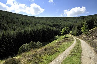
The most famous route at Glentrool is the 'Big Country' trail, based entirely on minor public roads and forest roads. The trail follows 58km (36mi) of road in a loop, starting and finishing at the Glentrool visitor centre. There are areas of off-road biking allowing riders of all experiences and age ranges to have a good time.
Forest roads or forest tracks are roads or tracks intended to carry motorised vehicles or horse-drawn wagons being used mainly or exclusively for forestry purposes, such as conservation or logging. Forest roads may be open to ramblers or mountain bikers depending on local rules.
In early 2007 the Forestry Commission built a blue graded route which is 8km (5mi) long and follows purpose built singletrack in a loop from the visitor centre to Loch Trool and finishes back at the visitor centre.
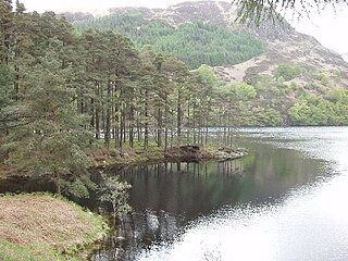
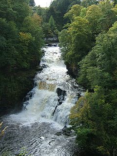
Loch Trool is a narrow, freshwater loch in Galloway, in the Southern Uplands in south-west Scotland. It lies in an elevated position in Glen Trool in the Galloway Forest Park and is approximately 8 miles (13 km) north of the town of Newton Stewart. The loch is the source of the Water of Trool which flows to the Water of Minnoch and the River Cree. There is a walking trail and footpath around the loch's perimeter.
Car parking and toilet facilities are available at the visitor centre also has a cafe with seasonal opening times from April to September.
A geographic coordinate system is a coordinate system that enables every location on Earth to be specified by a set of numbers, letters or symbols. The coordinates are often chosen such that one of the numbers represents a vertical position and two or three of the numbers represent a horizontal position; alternatively, a geographic position may be expressed in a combined three-dimensional Cartesian vector. A common choice of coordinates is latitude, longitude and elevation. To specify a location on a plane requires a map projection.
This page is based on this Wikipedia article Text is available under the CC BY-SA 4.0 license; additional terms may apply. Images, videos and audio are available under their respective licenses.
Related Research Articles
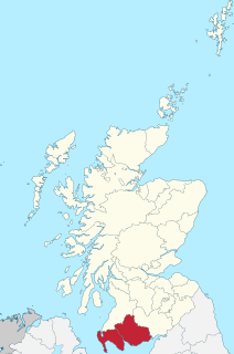
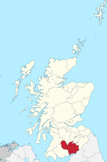
Dumfries and Galloway is one of 32 unitary council areas of Scotland and is located in the western Southern Uplands. It comprises the historic counties of Dumfriesshire, Stewartry of Kirkcudbright and Wigtownshire, the latter two of which are collectively known as Galloway. The administrative centre is the town of Dumfries.
Innerleithen is a civil parish and a small town in the committee area of Tweeddale, in the Scottish Borders. It was formerly in the historic county of Peeblesshire or Tweeddale.
Dumfriesshire or the County of Dumfries is a historic county, registration county and lieutenancy area of Scotland.
The Taff Trail is a popular walking and cycle path that runs for 55 miles (89 km) between Cardiff Bay and Brecon in Wales. It is so named because it follows the course of the River Taff. Along much of its length, it follows the National Cycle Network Route 8 that continues to Holyhead, and is substantially off-road.
The Afan Forest Park is a 48-square-mile (120 km2) forest park in Britain. It is set in the Afan Valley in Neath Port Talbot, in south Wales. It is well known for its mountain biking and hiking or hillwalking trails. It is situated seven miles (11 km) from Junction 40 of the M4.
Ae is a village in Dumfries and Galloway, south west Scotland. The village is located on the edge of a 15,000 acres (61 km2) man-made conifer forest, and is approximately 9 miles (14 km) north of Dumfries.
The Southern Uplands are the southernmost and least populous of mainland Scotland's three major geographic areas. The term is used both to describe the geographical region and to collectively denote the various ranges of hills and mountains within this region.
The Forest of Ae is located between Nithsdale and Annandale in Dumfries and Galloway in south-west Scotland.
Coed y Brenin is a forest in the Snowdonia National Park, North Wales near Dolgellau at grid reference SH7127. It is popular for its mountain bike trails and hiking paths. It has several man-made mountain bike singletrack courses in a woodland setting, varying in length from 12 to 38 km, and one dual slalom course.
The Southern Upland Way is a 338-kilometre (210 mi) long distance coast-to-coast trail in southern Scotland. The route links Portpatrick in the west and Cockburnspath in the east via the hills of the Southern Uplands. It opened in 1984, and was the UK’s first officially recognised coast-to-coast long-distance route. The Way is designated as one of Scotland's Great Trails by Scottish Natural Heritage, and is the longest of the 29 Great Trails. The Southern Upland Way meets with seven of the other Great Trails: the Annandale Way, the Berwickshire Coastal Path, the Borders Abbeys Way, the Cross Borders Drove Road, the Mull of Galloway Trail, the Romans and Reivers Route and St Cuthbert's Way.
The Clyde Walkway is a foot and mountain bike path which runs from Glasgow, Scotland, to just above the UNESCO World Heritage site of New Lanark. The path runs close to the River Clyde for most of its length. It was completed in 2005, and is now designated as one of Scotland's Great Trails by Scottish Natural Heritage. The route is 65 kilometres (40 mi) long, and combines rural sections on the upper Clyde in South Lanarkshire, including the Clyde Valley Woodlands National Nature Reserve and the Falls of Clyde, with urban walking through the centre of Glasgow. About 155,000 people use the path every year, of whom about 7,750 undertake multi-day journeys.
Glentress Forest is located near Peebles in the Scottish Borders, about 30 miles south of Edinburgh. Part of the Tweed Valley Forest Park along with Traquair Forest in Innerleithen, it is the home of a mountain biking centre which is one of the 7stanes mountain bike trails operated throughout southern Scotland by Forestry and Land Scotland.
The 7stanes are seven mountain biking centres spanning the south of Scotland, from the heart of the Scottish Borders to Dumfries and Galloway. They are all in Forestry and Land Scotland forests and are known as the 7stanes because each venue features a 'stane', created by artist Gordon Young, somewhere along the forest trails.
Galloway Forest Park is a forest park operated by Forestry and Land Scotland, principally covering woodland in Dumfries and Galloway. The Scottish Dark Sky Observatory, on the Craigengillan estate in South Ayrshire, at the edge of the Galloway Forest Dark Sky Park, was partly funded by the Scottish Government and opened in 2012. It is claimed to be the largest forest in the UK.
Mabie is a collection of mountain biking routes located in Dumfries and Galloway, southwest Scotland. The mountain bike routes are part of the 7Stanes project by Forestry and Land Scotland throughout the Scottish Borders and Dumfries and Galloway.
National Cycle Route 8 is a route of the National Cycle Network, running from Cardiff to Holyhead. The route passes through the heart of Wales, and is also known by its Welsh name Lôn Las Cymru. It is largely north-south from Holyhead to Cardiff or Chepstow, and in total measures some 400 km (250 mi) in length. Some of its route follows the trackbed of former railway lines, such as Lôn Las Menai, Lôn Eifion, the Mawddach Trail and the Taff Trail; in other places, the route is on public highways. A road bike with racing tyres would struggle on the former surfaces; a hybrid or 'hard tail' mountain bike fitted with wide road tyres would be a better choice.
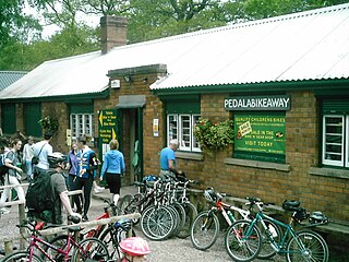
Cannop Cycle Centre is a small woodland cycling centre, comprising mountain bike trails, a visitor centre, car parks and uplift service. It is located on the former site of Cannop Colliery in the Cannop Valley, Forest of Dean, Gloucestershire. The nearest village is Parkend, 3 miles (5 km) away. The cycle centre (Pedalabikeaway) has been an active supporter of the Hands off our Forest campaign and hosted a 'cycle protest rally' in January 2011.
Bargrennan is a village in Dumfries and Galloway, in the south west of Scotland. It is located 9 miles northwest of Newton Stewart by the River Cree and on the A714 road to Girvan. The Southern Upland Way runs through the village and the Glentrool Forest, managed by the Forestry Commission, is to the north-east of the village.
Beecraigs is a country park located in West Lothian, approximately 2 miles (3.2 km) south of the town of Linlithgow and 3 miles (4.8 km) north-east of Bathgate and is a 4 star Visitor Attraction (Visitscotland). The Park comprises around 913 acres (369 ha) of upland forest, woodland and open country, and offers a range of amenities including walks & trails, play area, skills area & mountain bike trails, BBQ hire, caravan & camping site including 2 lodges, Countryside Ranger Service, animal attraction, fly fishery, Visitor Centre and Cafe. In 2010 prehistoric remains were uncovered on the site of the current visitor centre. To the west of the country park is privately owned Cockleroy Hill, which is topped by the remains of a prehistoric hillfort.
Mountain biking in the UK comprises a mix of dedicated mountain bike trail centres and other areas that have become popular with mountain bikers despite lacking dedicated facilities. The main governing body for mountain bike racing in the UK is British Cycling.