
The Aonach Eagach is a large mountain ridge in the Scottish Highlands, marking the northern edge of Glen Coe. It stretches east–west for several miles and includes two Munro summits: Sgùrr nam Fiannaidh at 967 m (3,175 ft) high, and Meall Dearg at 952 m (3,124 ft) high. The ridge is very rocky and the route along it requires scrambling ability. The slopes to each side are extremely dangerous, with steep grass-and-scree slopes hiding even steeper slopes which end in cliffs on both north and south sides of the ridge.

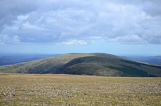
The Merrick, or simply Merrick, is a mountain in the Range of the Awful Hand, a sub-range of the Galloway Hills range, part of the Southern Uplands of Scotland. The summit elevation is 843 metres, making it the highest mountain in the Southern Uplands and southern Scotland.
Ben Vorlich is a mountain in the Southern Highlands of Scotland. It lies south of Loch Earn and Ardvorlich, and a short distance north of the neighbouring mountain Stùc a' Chroin. Ben Vorlich reaches a height of 985 metres (3,232 ft), making it a Munro.

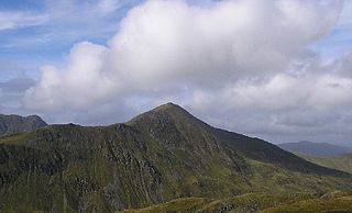
Sgùrr a' Mhàim is a mountain of the Mamores range in the Scottish Highlands. It is directly south of Ben Nevis, on the other side of Glen Nevis. With a height of 1,099 metres (3,605 feet), Sgùrr a' Mhàim is a Munro and the second-highest peak in the Mamores. Its cap of quartzite stones give it a light grey appearance which can be mistaken for a covering of snow.

Bynack More is a Scottish Mountain that is situated in the Cairngorms range, 16 kilometres east-south-east of the town of Aviemore in the Highland region.

Càrn a' Mhàim is a Scottish mountain situated in the inner part of the Cairngorms range, some 15 kilometres west of Braemar in the county of Aberdeenshire.

Gairich, sometimes Sgurr Gairoch, is a mountain in Lochaber in the Northwest Highlands of Scotland. It is on the southern side of Loch Quoich, with Glen Garry to the east and Glen Kingie to the south, 25 kilometres north-northwest of Fort William.

An Caisteal is a mountain in the Breadalbane region of the Scottish Highlands, south of the village of Crianlarich. It is a Munro with a height of 995 metres (3,264 ft).

Càrn Aosda is a Scottish mountain situated 12.5 km south of the town of Braemar, in the county of Aberdeenshire. It stands near the summit of the Cairnwell Pass on the A93 road, in the midst of the Glenshee Ski Centre.

Càrn a' Gheòidh or Càrn Gheòidh is a mountain in the Mounth region of the Scottish Highlands. It lies 15 km south of the town of Braemar. Its summit stands on the border between the council areas of Perth and Kinross and Aberdeenshire.

The Range of the Awful Hand is a range of hills in the Galloway Hills range, part of the Southern Uplands of Scotland. The most westerly of three parallel ridges, the range is neighboured to the east by the Dungeon Hills and the Rhinns of Kells. The Minnigaff Hills also lie southeast. In total, these four ranges are part of the Galloway Forest Park. The ridge is split between South Ayrshire and Dumfries and Galloway.

Lamachan Hill is a hill in the Minnigaff Hills, a sub-range of the Galloway Hills range, part of the Southern Uplands of Scotland. It is the highest hill of the range, lying 11 kilometres (7 mi) north of Newton Stewart in Dumfries and Galloway.

Under Saddle Yoke is a hill in the Moffat Hills range, part of the Southern Uplands of Scotland. Despite its name, it is 10m higher than its neighbouring top, Saddle Yoke. Located in a dramatic position on a small, grassy ridge in between two deep glens, Blackhope and Carrifran, it awards excellent views into the rest of the Moffat Hills and the Ettrick Hills opposite. Although incomparable to the Scottish Highlands and not particularly precipitous, the ridge between and atop the Yokes is the narrowest summit ridge in the Southern Uplands. The electric fence that comes out of Blackshope and crosses the ridge to the north of Saddle Yoke and then continues down into Carrifran hasn't worked in 40 years. A popular round known as the Hart Fell Horseshoe begins near Blackshope and normally ascends Nether Coomb Craig first, then passing over Swatte Fell, Hart Fell and looping round Hartfell Rig to the Saddle Yokes before the descent.

Millfore is a hill in the Minnigaff Hills, a sub-range of the Galloway Hills range, part of the Southern Uplands of Scotland. It lies northeast of Newton Stewart in Galloway Forest Park, Dumfries and Galloway. One of the less-visited of the Galloway Hills, it nonetheless provides excellent views from its summit over its neighbours and Loch Dee. Isolated from its westerly neighbours by the White Laggan glen, it is frequently climbed on its own from Clatteringshaws Loch to the east.
Meikle Millyea is a hill in the Rhinns of Kells, a sub-range of the Galloway Hills range, part of the Southern Uplands of Scotland. The true summit of the hill has been disputed over the years; a 2015 survey concluded that the southwest top, around 400m southwest from the trig point and cairn is approximately 2m higher.

Larg Hill is a hill in the Minnigaff Hills, a sub-range of the Galloway Hills range, part of the Southern Uplands of Scotland. The second highest and most westerly of the range, it is normally ascended with Lamachan Hill as part of a round normally starting from the north or south. Historically it was covered by woodland consisting of ash, oak, fir and beech.

Curleywee is a hill in the Minnigaff Hills, a sub-range of the Galloway Hills range, part of the Southern Uplands of Scotland. It is normally ascended with Lamachan Hill as part of a round normally starting from the north or south.
The Dungeon Hills are a range of hills in the Galloway Hills range, part of the Southern Uplands of Scotland. The central of three parallel ridges, they are neighboured by the Range of the Awful Hand to the west and the Rhinns of Kells to the east. The range is also perpendicular to the Minnigaff Hills range, immediately south. In total, these four ranges are part of the Galloway Forest Park.

The Rhinns of Kells are a range of hills in the Galloway Hills range, part of the Southern Uplands of Scotland. The most easterly of three parallel ridges, they are neighboured to the west by the Range of the Awful Hand and the Dungeon Hills. The eastern portion of the Minnigaff Hills range lies immediately southwest of the range. In total, these four ranges are part of the Galloway Forest Park. The ridge is located entirely within Dumfries and Galloway, with the base of the western flanks being a northwestern boundary of the county.

The Culter Hills, Coulter Fells or variations thereof, are a range of hills, part of the Southern Uplands of Scotland. They are neighboured to the east by the Manor Hills and are split roughly in half by the border between South Lanarkshire and the Scottish Borders.
