
Trail riding is riding outdoors on trails, bridle paths, and forest roads, but not on roads regularly used by motorised traffic. A trail ride can be of any length, including a long distance, multi-day trip. It originated with horse riding, and in North America, the equestrian form is usually called "trail riding," or, less often "hacking." In the UK and Europe, the practice is usually called horse or pony trekking.
Dumfriesshire or the County of Dumfries is a historic county, registration county and lieutenancy area of Scotland.

Nithsdale, also known by its anglicised Gaelic name Strathnith, Stranith or Stranit, is the strath of the River Nith in Scotland, and the name of the region. It is possible that Strath Nid actually represents the Cumbric Ystrad Nidd as Cumbric was the dominant language in this area from before Roman times until the 11th or 12th Century whereas Gaelic influence here was late and transient. The River Nith flows north to south through the Southern Uplands in south-west Scotland, separating the Lowther hills from the Scaur hills. Nithsdale has historically been a strategic area as it forms an invasion route from England into central Scotland.

Annandale is a strath in Dumfries and Galloway, Scotland, named after the River Annan. It runs north–south through the Southern Uplands from Annanhead to Annan on the Solway Firth, and in its higher reaches it separates the Moffat hills on the east from the Lowther hills to the west. A 53-mile (85 km) long-distance walking route called Annandale Way running through Annandale was opened in September 2009.
The Afan Forest Park is a 48-square-mile (120 km2) forest park in Britain. It is set in the Afan Valley in Neath Port Talbot, in south Wales. It is well known for its mountain biking and hiking or hillwalking trails. It is situated seven miles (11 km) from Junction 40 of the M4.

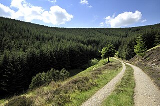
Ae is a village in Dumfries and Galloway, south west Scotland. The village is located on the edge of a 15,000 acres (61 km2) man-made conifer forest, and is approximately 9 miles (14 km) north of Dumfries.

The Southern Uplands are the southernmost and least populous of mainland Scotland's three major geographic areas. The term is used both to describe the geographical region and to collectively denote the various ranges of hills and mountains within this region.

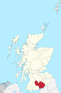
The Forest of Ae is located between Nithsdale and Annandale in Dumfries and Galloway in south-west Scotland.

The Southern Upland Way is a 338-kilometre (210 mi) long distance coast-to-coast trail in southern Scotland. The route links Portpatrick in the west and Cockburnspath in the east via the hills of the Southern Uplands. It opened in 1984, and was the UK’s first officially recognised coast-to-coast long-distance route. The Way is designated as one of Scotland's Great Trails by Scottish Natural Heritage, and is the longest of the 29 Great Trails. The Southern Upland Way meets with seven of the other Great Trails: the Annandale Way, the Berwickshire Coastal Path, the Borders Abbeys Way, the Cross Borders Drove Road, the Mull of Galloway Trail, the Romans and Reivers Route and St Cuthbert's Way.
Glentress Forest is located near Peebles in the Scottish Borders, about 30 miles south of Edinburgh. Part of the Tweed Valley Forest Park along with Traquair Forest in Innerleithen, it is the home of a mountain biking centre which is one of the 7stanes mountain bike trails operated throughout southern Scotland by Forestry and Land Scotland.

The 7stanes are seven mountain biking centres spanning the south of Scotland, from the heart of the Scottish Borders to Dumfries and Galloway. They are all in Forestry and Land Scotland forests and are known as the 7stanes because each venue features a 'stane', created by artist Gordon Young, somewhere along the forest trails.

Galloway Forest Park is a forest park operated by Forestry and Land Scotland, principally covering woodland in Dumfries and Galloway. The Scottish Dark Sky Observatory, on the Craigengillan estate in South Ayrshire, at the edge of the Galloway Forest Dark Sky Park, was partly funded by the Scottish Government and opened in 2012. It is claimed to be the largest forest in the UK.
Glentrool is a collection of mountain biking routes through the heart of Galloway in southwest Scotland. The mountain bike routes are part of the 7Stanes project by Forestry and Land Scotland throughout the Scottish Borders and Dumfries and Galloway.
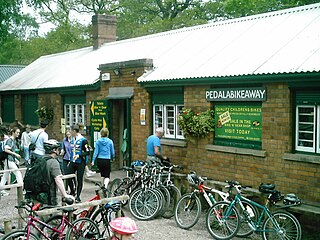
Cannop Cycle Centre is a small woodland cycling centre, comprising mountain bike trails, a visitor centre, car parks and uplift service. It is located on the former site of Cannop Colliery in the Cannop Valley, Forest of Dean, Gloucestershire. The nearest village is Parkend, 3 miles (5 km) away. The cycle centre (Pedalabikeaway) has been an active supporter of the Hands off our Forest campaign and hosted a 'cycle protest rally' in January 2011.

The Mull of Galloway Trail is a coastal long-distance path in Dumfries and Galloway, Scotland. The route, which is 59 km (37 mi) long, runs along the coast from Glenapp near Ballantrae to the Mull of Galloway. The path was developed by the Rotary Club of Stranraer, who maintain the route on a voluntary basis. It opened in 2012, and is now designated as one of Scotland's Great Trails by Scottish Natural Heritage. It also forms part of the International Appalachian Trail.
The Romans and Reivers Route is a long-distance path in southern Scotland, linking the Forest of Ae in Dumfries and Galloway with Hawick in the Scottish Borders. The route, which is 84 km long, uses forest tracks, drovers' roads and some sections of public road to link Roman roads across the border country of Scotland. It takes its name from these roads, and the fact that it passes through areas associated with the Border Reivers, the name given to cattle raiders along the Anglo-Scottish border between late 13th century to the beginning of the 17th century. The route is intended to be suitable for walkers, cyclists and horseriders, having been specifically developed to include features such as self-closing gates.

Forestry and Land Scotland (FLS) is responsible for managing and promoting Scotland's national forest estate: land, predominantly covered in forest, that is owned by the Scottish Government on behalf of the nation. It was formed on 1 April 2019, to take over some of the responsibilities of Forestry Commission Scotland, which was dissolved. Forestry and Land Scotland exists alongside Scottish Forestry, also established on 1 April 2019, which is responsible for regulation, policy and support to landowners. The organisation's key functions are to look after the national forest estate, including unforested land within this portfolio, and to produce and supply timber. Within this remit they are expected to enhance biodiversity, increase public access to the outdoors, encourage tourism and support the rural economy.
Tweed Valley Forest Park is forest park in the border region of Scotland. It consists of a network of eight forests managed by Forestry and Land Scotland (FLS) spread along the valley of the River Tweed, and which are managed with an emphasis on recreational facilities for visitors.


