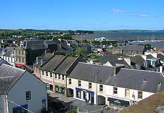
Stranraer, also known as The Toon, is a town in Dumfries and Galloway, Scotland. It is located in the historical parish of Inch in the historic county of Wigtownshire. It lies on the shores of Loch Ryan, on the northern side of the isthmus joining the Rhins of Galloway to the mainland. Stranraer is Dumfries and Galloway's second-largest town, with a population including the immediate surrounding area of nearly 13,000 inhabitants.

Newton Stewart is a former burgh town in the historical county of Wigtownshire in Dumfries and Galloway, southwest Scotland. The town is on the River Cree with most of the town to the west of the river, and is sometimes referred to as the "Gateway to the Galloway Hills".

Loch Lomond and The Trossachs National Park is a national park in Scotland centred on Loch Lomond and the hills and glens of the Trossachs, along with several other ranges of hills. It was the first of the two national parks established by the Scottish Parliament in 2002, the second being the Cairngorms National Park. The park extends to cover much of the western part of the southern highlands, lying to the north of the Glasgow conurbation, and contains many mountains and lochs. It is the fourth-largest national park in the British Isles, with a total area of 1,865 km2 (720 sq mi) and a boundary of some 350 km (220 mi) in length. It features 21 Munros and 20 Corbetts.
The Afan Forest Park is a 48-square-mile (120 km2) forest park in Britain. It is set in the Afan Valley in Neath Port Talbot, in south Wales. It is well known for its mountain biking and hiking or hillwalking trails. It is situated seven miles (11 km) from Junction 40 of the M4.

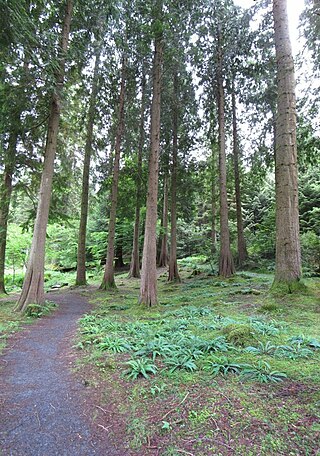
Ae is a village in Dumfries and Galloway, south west Scotland. The village is located on the edge of a 15,000-acre (61 km2) man-made conifer forest, and is approximately 9 miles (14 km) north of Dumfries.

The Southern Uplands are the southernmost and least populous of mainland Scotland's three major geographic areas. The term is used both to describe the geographical region and to collectively denote the various ranges of hills and mountains within this region. An overwhelmingly rural and agricultural region, the Southern Uplands are partly forested and contain many areas of open moorland - the hill names in the area are congruent with these characteristics.

The Forest of Ae is located between Nithsdale and Annandale in Dumfries and Galloway in south-west Scotland.
Coed y Brenin is a forest in the Snowdonia National Park, North Wales near Dolgellau at grid reference SH7127. It is popular for its mountain bike trails and hiking paths. It has several man-made mountain bike singletrack courses in a woodland setting, varying in length from 12 to 38 km, and one dual slalom course.

Clatteringshaws Loch is a freshwater reservoir in the historical county of The Stewartry of Kirkcudbright in Dumfries and Galloway, Scotland. It was created by damming the Galloway River Dee as part of the Galloway Hydro Electric Scheme.
Glentress Forest is located near Peebles in the Scottish Borders, about 30 miles south of Edinburgh. Part of the Tweed Valley Forest Park along with Traquair Forest in Innerleithen, it is the home of a mountain biking centre which is one of the 7stanes mountain bike trails operated throughout southern Scotland by Forestry and Land Scotland. It is at the southern end of the Moorfoot Hills and is accessed from the A72 road.

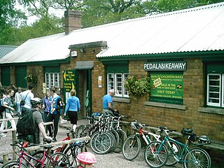
The 7stanes are seven mountain biking centres spanning the south of Scotland, from the heart of the Scottish Borders to Dumfries and Galloway. They are all in Forestry and Land Scotland forests and are known as the 7stanes because each venue features a 'stane', created by artist Gordon Young, somewhere along the forest trails.
Alafia River State Park is a Florida State Park, located near Picnic in Hillsborough County in central Florida, 17 miles southeast of Tampa on County Road 39. Even before it became a park, the area, and particularly Hurrah Lake, was the center of leisure activities since the early 1880s.

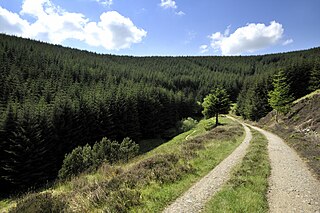
Galloway Forest Park is a forest park operated by Forestry and Land Scotland, principally covering woodland in Dumfries and Galloway. It is claimed to be the largest forest in the UK. The park was granted Dark Sky Park status in November 2009, being the first area in the UK to be so designated.
Glentrool is a collection of mountain biking routes through the heart of Galloway in southwest Scotland. The mountain bike routes are part of the 7Stanes project by Forestry and Land Scotland throughout the Scottish Borders and Dumfries and Galloway.
Mabie is a collection of mountain biking routes located in Dumfries and Galloway, southwest Scotland. The mountain bike routes are part of the 7Stanes project by Forestry and Land Scotland throughout the Scottish Borders and Dumfries and Galloway.

Beecraigs is a country park in West Lothian, approximately 2 miles (3.2 km) south of the town of Linlithgow and 3 miles (4.8 km) north-east of Bathgate and is a 4 star Visitor Attraction (Visitscotland). The Park comprises around 913 acres (369 ha) of upland forest, woodland and open country, and offers a range of amenities including walks & trails, play area, skills area & mountain bike trails, BBQ hire, caravan & camping site including 2 lodges, Countryside Ranger Service, animal attraction, fly fishery, Visitor Centre and Cafe. In 2010 prehistoric remains were uncovered on the site of the current visitor centre. To the west of the country park is privately owned Cockleroy Hill, which is topped by the remains of a prehistoric hillfort.
Mountain biking in the UK comprises a mix of dedicated mountain bike trail centres and other areas that have become popular with mountain bikers despite lacking dedicated facilities. The main governing body for mountain bike racing in the UK is British Cycling.

Forestry and Land Scotland (FLS) is responsible for managing and promoting Scotland's national forest estate: land, predominantly covered in forest, owned by the Scottish Government on behalf of the nation. It was formed on 1 April 2019, to take over some of the responsibilities of Forestry Commission Scotland, which was dissolved. The organisation exists alongside Scottish Forestry, also established on 1 April 2019, which is responsible for regulation, policy and support to landowners. Forestry and Land Scotland's key functions are to look after the national forest estate, including unforested land within this portfolio, and to produce and supply timber. Within this remit they are expected to enhance biodiversity, increase public access to the outdoors, encourage tourism and support the rural economy.
Tweed Valley Forest Park is forest park in the border region of Scotland. It consists of a network of eight forests managed by Forestry and Land Scotland (FLS) spread along the valley of the River Tweed, and which are managed with an emphasis on recreational facilities for visitors.


