Inch, Dumfries and Galloway

Last updated

Inch
Castle of St John, Stranraer.jpg
View east from the top of the Castle of St. John, Stranraer, looking over Loch Ryan towards Inch.
Dumfries and Galloway UK location map.svg
Red pog.svg
Inch
Location within Dumfries and Galloway
Council area
Lieutenancy area
Country Scotland
Sovereign state United Kingdom
Police Scotland
Fire Scottish
Ambulance Scottish
UK Parliament
Scottish Parliament
List of places
UK
Scotland
54°57′N4°57′W / 54.95°N 4.95°W / 54.95; -4.95 Coordinates: 54°57′N4°57′W / 54.95°N 4.95°W / 54.95; -4.95

Inch is a civil parish in Dumfries and Galloway, southwest Scotland. It lies on the shore of Loch Ryan, in the traditional county of Wigtownshire. [1]

Contents

The parish is 10 miles (16 km) in length, and in one part nearly of the same breadth, comprising 30,600 acres (12,400 ha). [2] [3]

Location

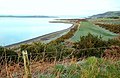
The northern section of the parish lies between Loch Ryan and the Water of Luce and consists of hills and heath. The southern section lies chiefly in the isthmus between Loch Ryan and Luce Bay, and is low and gently undulating. The principal town is Stranraer, which is partly within the parish. The Water of Luce, which flows south into Luce Bay, divides the parish from New Luce to the east. [4]

Settlements

At Lochans Village there is a Community Centre and Primary School. Nearby is Kilhilt (also spelt Kinhilt), which gave its name to the Barony of Killhelt. The village of Castle Kennedy, 3 miles (4.8 km) east of Stranraer, is named after the castle which was built in 1607, and burned down in 1716. Stranraer remains the largest settlement in the parish, although the Northern Ireland ferries which called there now sail from Cairnryan. The European Union is partly financing a project to enhance the Stranraer and Loch Ryan waterfront. [5]

History

The name "Inch" is of Gaelic origin, and means an island or a meadow. It is found quite commonly in Scottish place names.

On 9–10 February 1307 the Battle of Loch Ryan was fought during the Scottish Wars of Independence near Stranraer.

This area has been known as, and has been recorded in deeds and charters, as Inch and Insche from about the 15th century, when it was part of the Sheriffdom of Wigtown. In the 16th and 17th centuries, Wigtownshire was composed of baronies which were controlled and defended by the hereditary barons. For example, in 1608 William Adair, Commendator of Soulseat Abbey, was served heir to his father, Ninian Adair of Kinhilt, to the 4 merklands of Stranraver, to the port and burgh of the Barony of Stranraer, Inch, together with many lands in the Barony of Kinhilt, Inch. [6] Inche baronia is referred to in a deed 16 December 1528. [7]

From the 15th century, the Kennedy family were baillies of Inch Parish, collecting taxes and owning and leasing property. [8] Gilbert Kennedy, Earl of Cassillis, a powerful man in Galloway, was granted Ochterlour, south of Stranraer in Inch Parish. [9] [10]

On 25 March 1516 there was a commission to Gilbert Kennedy, 2nd Earl of Cassilis, to be captain and keeper of the manor place and loch of Inch. [11] On 20 June 1605 at the New Castle of Inch was feued by the Crown to John Kennedy, 5th Earl of Cassilis. [12] [13]

On 25 June 1942 during World War II, when making his second visit to the USA, Winston Churchill flew out of Loch Ryan on a flying boat to meet President Roosevelt. During the war Cairnryan became an important No. 2 Military port for England and Scotland. Two large piers were built and the harbour was used for troops coming from the USA after 1942. The area became an important centre for anti-U-boat operations. Flying boats operated from the loch to protect allied shipping making its way to Liverpool or Glasgow. With easy access to the North Atlantic, Loch Ryan was used as the surrender destination for the U-boats which were out in the Atlantic in 1945, and the U-boats and their crews were held at Cairnryan, before the boats were towed out to sea and sunk.

Places of interest

The chief antiquities include Innermessan Motte, Craigcaffie Broch (Teroy Broch), [14] [15] Craigcaffie Castle, the remains of Larg Castle, the standing stones of Glenterra, and numerous cairns. [16] The remains of the 12th-century Soulseat Abbey are situated by the herb garden on the south side of Soulseat Loch. [17] [18]

The old House of Croach north-east of Meikle Laight farmhouse, was probably built c. 1460 after the lands were detached from the Agnew family estate in favour of William Agnew, 2nd son of Sir Andrew Agnew, and it was occupied by members of that family until 1701 when they built Lochryan House. [19] [20] The ruined walls of Croach, east of Cairn Point, are about 4 feet (1.2 m) wide. [21] Craig Caffie Tower was built around 1580 near Innermessan. In 1847 a lighthouse was built at Cairn Point at the northern end of the village of Cairnryan.

Ferries for Northern Ireland leave from Loch Ryan, on the western border of Inch. This is the shortest crossing between Britain and Ireland. There are four conventional RORO ferries and two fast ferries from Cairnryan. [22]

Brochs, forts and other monuments

A fortified town was located at Shinraggie or Shinriggie at the head of Beoch Glen. [23] [24] A broch is located at Craigcaffie, [15] while a motte is shown at Cults on old Ordnance Survey maps. [25] [26] There is a hut circle at Little Laight on the western flank of Laight Moor, 350 metres (1,150 ft) from the summit. [27] White Cairn is located near the Shinriggie fortified town. [28] There are crannogs at Cults Loch and Black Loch. [26] [29] [30] [31] [32]

Parish church

The parish church is located on the shore of Loch Inch, and before the Scottish Reformation it belonged to the Bishop of Galloway. Within the parish there existed two chapels, that of St John in Stranraer, and the chapel of St Patrick in Portpatrick. The latter was called the Black Quarter of the Inch, but became a separate parish in 1628. The church was located at the now-nonexistent village of Inch. [33] Opposite the church, within the Loch, is an island, from which the area derives its name: inch is a Scots and Irish word for island, derived from the Gaelic innis. This island is about 550 metres (1,800 ft) in circumference, and formerly held a place of worship, vestiges of which are still remaining. It communicated with the land by a causeway and drawbridge. About 1130 St Malachy visited Galloway on three occasions and on one visit beside the Green Lake, he decided to plant a community, being influenced that it lay within a mile or so of the manor of Inch which was the seat of the Bishop of Galloway. [34]

In 1931, following the union of the Church of Scotland and the United Free Church in 1929, the parish church of Inch was united with the former United Free Church congregation of Inch at Castle Kennedy. After the union the former Castle Kennedy Church was converted for use as a church hall. [35]

In 1982 Inch was linked with Stranraer St Andrew's and a union later followed between Inch and Loch Ryan in 1985. After the union the parish, which continued under the name of Inch, remained linked to Stranraer St Andrew's. The kirk session sat within the Presbytery of Stranraer until 1963 when, by Act of Assembly, the Presbytery of Wigtown and the Presbytery of Stranraer were united under the name of the Presbytery of Wigtown and Stranraer. [36]

Cairnryan Free Church began as an extension charge before the disruption of 1843. It was separately sanctioned in 1844, with a church opened in the following year. It transferred to the United Free Church in 1900, but the minister retired in the same year and it was served by probationers and missionaries, and did not transfer to the Church of Scotland. The UFC charge was in the presbytery of Wigtown and Stranraer and the synod of Dumfries and Galloway. In 1858 the Parish of Loch Ryan was disjoined from that of Inch, and erected quoad sacra ; the church of this parish had been built at Cairnryan a number of years prior in 1841. In 1941 the charge of Loch Ryan was united to Glenapp, Ballantrae to form the session of Lochryan and Glenapp, and following the local union both parish churches remained in use for public worship. In 1985 the union between Glenapp and Lochryan was dissolved in favour of a union between Loch Ryan and Inch under the name of Inch. The kirk session sat within the Presbytery of Stranraer until 1963 when, by Act of Assembly, the Presbytery of Wigtown and the Presbytery of Stranraer were united together under the name of the Presbytery of Wigtown and Stranraer.

University of Glasgow's archaeology project in Inch

The Local History and Archaeology Group are taking part in the University of Glasgow's community archaeology project in Inch – Discovering Dumfries and Galloway's Past. From September 11–15, 2012 there will be a group working with Giles Carey doing a geo-physics survey of the area to the north of the motte at Innermessan between Stranraer and Cairnryan. It is a site with a very long history – from early mesolithic ancestors, about 10,000 years ago to a medieval town, now disappeared, which in its time was more important than Stranraer. The funding for the first phase of the study is until February 2013, but it is hoped that once the geo-physics investigations have taken place, further funding will enable a more thorough investigation over a three-year period. [37] [38]

Innermessan

Innermessan was a medieval town in the parish of Inch [39] [40] [41] which now no longer exists. [42] Innermessan was the most considerable place in the Rhins and the greatest town thereabout till Stranraer was built. [43] [44] [45] "Innermeason" is recorded in a charter by King David II of Scotland (reigned 1329 – 1371) to the Bishop of Galloway, "of the lands of Dermore, in the Rins Rhins within the town of Innermeasan. [46] David II was son of King Robert the Bruce. The barony and ville of Invermessan (baronia ville de Invermassan) was in a deed of 14 October 1426. [47] Another deed of 25 March 1566 noted the Baronia of Invermessene. [48] A mound at Balyett is thought to be the site of a Norman timber-built castle. Later in Innermessan's history the town grew around a substantial estate with power over the imports and exports in Loch Ryan and eventually became Loch Ryan's largest settlement. [39] Finds indicate that a Roman road passed through Innermessan. [42]

See also

Related Research Articles

<span class="mw-page-title-main">Dumfries and Galloway</span> Council area of Scotland

Dumfries and Galloway is one of 32 unitary council areas of Scotland and is located in the western Southern Uplands. It covers the historic counties of Dumfriesshire, Kirkcudbrightshire, and Wigtownshire, the latter two of which are collectively known as Galloway. The administrative centre and largest settlement is the town of Dumfries. The second largest town is Stranraer, on the North Channel coast, some 57 miles (92 km) to the west of Dumfries.

<span class="mw-page-title-main">Stranraer</span> Town and sea port in Scotland

Stranraer, also known as The Toon, is a town in Dumfries and Galloway, Scotland. It is located in the historical parish of Inch in the historic county of Wigtownshire. It lies on the shores of Loch Ryan, on the northern side of the isthmus joining the Rhins of Galloway to the mainland. Stranraer is Dumfries and Galloway's second-largest town, with a population including the immediate surrounding area of nearly 13,000 inhabitants.

<span class="mw-page-title-main">Kirkcudbrightshire</span> Historic county in Scotland

Kirkcudbrightshire, or the County of Kirkcudbright or the Stewartry of Kirkcudbright is one of the historic counties of Scotland, covering an area in the south-west of the country. Until 1975, Kirkcudbrightshire was an administrative county used for local government. Since 1975, the area has formed part of Dumfries and Galloway for local government purposes. Kirkcudbrightshire continues to be used as a registration county for land registration. A lower-tier district called Stewartry covered the majority of the historic county from 1975 to 1996. The area of Stewartry district is still used as a lieutenancy area. Dumfries and Galloway Council also has a Stewartry area committee.

<span class="mw-page-title-main">Wigtownshire</span> Historic county in Scotland

Wigtownshire or the County of Wigtown is one of the historic counties of Scotland, covering an area in the south-west of the country. Until 1975, Wigtownshire was an administrative county used for local government. Since 1975 the area has formed part of Dumfries and Galloway for local government purposes. Wigtownshire continues to be used as a territory for land registration, being a registration county. The historic county is all within the slightly larger Wigtown Area, which is one of the lieutenancy areas of Scotland and was used in local government as the Wigtown District from 1975 to 1996.

<span class="mw-page-title-main">Rhins of Galloway</span> Peninsula in Scotland

The Rhins of Galloway, otherwise known as the Rhins of Wigtownshire, is a hammer-head peninsula in Dumfries and Galloway, Scotland. Stretching more than 25 miles from north to south, its southern tip is the Mull of Galloway, the southernmost point of Scotland.

<span class="mw-page-title-main">Glenluce</span> Human settlement in Scotland

Glenluce is a small village in the parish of Old Luce in Wigtownshire, Scotland.

<span class="mw-page-title-main">New Luce</span> Civil parish in south-west Scotland

New Luce is a civil parish in Dumfries and Galloway, south-west Scotland. It lies in the traditional county of Wigtownshire, and is about 10 miles (16 km) in length and 5 miles (8.0 km) in breath, being the upper part of the original Glenluce Parish. New Luce is shown as a civil parish on John Ainslie's county map of 1782.

<span class="mw-page-title-main">Wigtown Area</span> Scottish lieutenancy area and former local government district

Wigtown is a lieutenancy area in south-west Scotland and a committee area of Dumfries and Galloway Council. From 1975 until 1996 it was also a local government district. It closely resembles the historic county of Wigtownshire, covering the whole area of that county but also including the two parishes of Kirkmabreck and Minnigaff from the historic county of Kirkcudbrightshire.

Sorbie is a small village in Wigtownshire, Machars, within the Administration area of Dumfries and Galloway Council, Scotland.

<span class="mw-page-title-main">Dunskey Castle</span>

Dunskey Castle is a ruined, 12th-century tower house or castle, located 0.5 miles (0.80 km) south of the village of Portpatrick, Rhinns, Wigtownshire, on the south-west coast of Scotland.

Mochrum is a coastal civil and Church of Scotland parish situated to the east of Luce Bay on the Machars peninsula and 8 miles (13 km) southwest of Wigtown and in the historical county of Wigtownshire in Galloway, Scotland. It covers 22,000 acres (8,900 ha) and is approximately 10 miles (16 km) in length and 5 miles (8.0 km) in breadth. The parish contains the eponymous village of Mochrum, as well as Port William and the clachan of Elrig.

Kirkcowan is an area about 15 miles in length, and from nearly two to nearly seven miles in breadth, comprising 30,580 acres, of which 7000 are arable, 300 woodland and plantations, and the remainder meadow, pasture in Machars, in the historical county of Wigtownshire, in Dumfries and Galloway, Scotland, with the village of Kirkcowan, bounded on the east by the river Bladnoch, on the west by the river Tarff, and is 6 miles W. by S.W. from Newton Stewart.

Stoneykirk is an area and a village in the heart of the Rhins of Galloway, Wigtownshire, in the administrative council area of Dumfries and Galloway, Scotland nearly 10 miles (16 km) in length and 3+12 miles (5.6 km) in breadth, bounded on the east by the bay of Luce, and on the west by the Irish Channel, 5 miles (8 km) south of Stranraer.

<span class="mw-page-title-main">Castle Kennedy</span> Human settlement in Scotland

Castle Kennedy is a small village 3 miles (4.8 km) east of Stranraer in Dumfries and Galloway, south-west Scotland. It is on the A75 road, and is within the civil parish of Inch. The village is to the south of the Lochinch Castle estate, which includes the ruins of the 17th-century Castle Kennedy, as well as Castle Kennedy Gardens which are open to the public.

<span class="mw-page-title-main">Galloway and West Dumfries (Scottish Parliament constituency)</span> Region or constituency of the Scottish Parliament

Galloway and West Dumfries is a constituency of the Scottish Parliament (Holyrood) covering part of the council area of Dumfries and Galloway. It elects one Member of the Scottish Parliament (MSP) by the plurality method of election. It is also one of nine constituencies in the South Scotland electoral region, which elects seven additional members, in addition to the nine constituency MSPs, to produce a form of proportional representation for the region as a whole.

<span class="mw-page-title-main">Kirkcolm</span> Human settlement in Scotland

Kirkcolm is a village and civil parish on the northern tip of the Rhinns of Galloway peninsula, south-west Scotland. It is in Dumfries and Galloway, and is part of the former county of Wigtownshire. The parish is bounded on the north and west by the sea, on the east by the bay of Loch Ryan and on the south by Leswalt parish.

Penninghame in Wigtownshire, Dumfries and Galloway, Scotland, is a civil parish area, 8 miles from Wigtown. The area is approx 16 miles in length, and from 5 to 6 miles' width, bounded on the north and east by the River Cree, and on the west by the Bladnoch; comprising nearly 38,000 acres, of which 12,000 were arable, 600 woodland and plantations, 1600 meadow, and the remainder hill pasture, moorland, moss, etc.

Old Luce is a civil parish in Dumfries and Galloway, Scotland. It lies in the Machars peninsula, in the traditional county of Wigtownshire. The parish is around 10 miles (16 km) long and 8 miles (13 km) broad, and contains 40,350 acres (16,330 ha).

<span class="mw-page-title-main">Stranraer and the Rhins (ward)</span>

Stranraer and the Rhins(Ward 1) is one of the twelve wards used to elect members of Dumfries and Galloway Council in Scotland. It elects four Councillors under the Single Transferable Vote system.

References

  1. The Imperial gazetteer of Scotland. 1854. Vol.II. (GORDON-ZETLAND) by Rev. John Marius Wilson. pp.101–102. https://archive.org/stream/imperialgazettee02wilsuoft#page/101/mode/1up
  2. "Parish of Inch from The Gazetteer for Scotland". www.scottish-places.info. Archived from the original on 14 September 2021. Retrieved 14 September 2021.
  3. "View map: A map of the county of Wigton. – Counties of Scotland, 1580–1928". maps.nls.uk. Archived from the original on 14 September 2021. Retrieved 14 September 2021.
  4. "The Old Statistical Account of Scotland (1791–99)". Stat-acc-scot.edina.ac.uk. pp. 134–135. Archived from the original on 22 February 2022. Retrieved 2 September 2012.
  5. "Archived copy". Archived from the original on 4 March 2012. Retrieved 3 September 2012.{{cite web}}: CS1 maint: archived copy as title (link)
  6. Caledonia. by George Chalmers. Vol.3. p.407. https://archive.org/stream/caledoniaoraccou03chal#page/407/mode/1up
  7. Registrum magni sigilli regum Scotorum AD1513-1546. p.157 no.719 https://archive.org/stream/registrummagnisi03scot#page/157/mode/1up
  8. The Exchequer Rolls of Scotland, edited by George Burnett, Lyon King of Arms, pub.AD1878+
  9. Parish Lists of Wigtownshire AD1684. p.15 Parish of Inch. https://archive.org/stream/parishlistsofwig72scot#page/15/mode/1up
  10. Wigtownshire Charters. https://books.google.com/books?id=QvdAAAAAYAAJ&q=Inch
  11. Culzean Charters. No.239
  12. "History of Soulseat, in Dumfries and Galloway and Wigtownshire | Map and description". Visionofbritain.org.uk. Archived from the original on 21 September 2013. Retrieved 21 February 2022.
  13. Register of the Great Seal of Scotland. vol.VI. p.592 no.1633 https://archive.org/stream/registrummagnisi06scot#page/592/mode/2up
  14. "Teroy Broch – The Modern Antiquarian.com". Themodernantiquarian.com. Archived from the original on 2 April 2015. Retrieved 21 February 2022.
  15. 1 2 "Teroy Fort [Craigcaffie] Broch or Nuraghe : The Megalithic Portal and Megalith Map". Archived from the original on 14 November 2012. Retrieved 18 October 2012.
  16. The Gazetteer of Scotland by Rev. John M. Wilson. https://archive.org/stream/gazetteerofscotl00wilsuoft#page/237/mode/1up
  17. History of Saulseat o'wise Soulseat Abbey. "Copyright and Intellectual Property Cover Sheet". Archived from the original on 9 February 2012. Retrieved 18 September 2012.
  18. RCAHMS Remains of Soulseat Abbey. http://canmore.rcahms.gov.uk/en/site/61217/details/soulseat+abbey/ Archived 2 April 2015 at the Wayback Machine
  19. "High Croach, Fairy Knowes | Canmore". canmore.org.uk. Archived from the original on 14 September 2021. Retrieved 14 September 2021.
  20. A Agnew 1893; P H M'Kerlie 1870; 1877.
  21. 1782 Ainslie map
  22. "UK | Scotland | South of Scotland | Ferry terminal plan makes headway". BBC News. 8 January 2009. Archived from the original on 20 December 2014. Retrieved 2 September 2012.
  23. map of Shinriggie fortified town https://www.geograph.org.uk/mapper/?t=tolJ5oOXXJ0oOXJFoOXXJfoONNJqoMbXJL5405oab4atblahN4Valut&gridref_from=NX0865 Archived 24 September 2015 at the Wayback Machine
  24. Archaeological and Historical Collections relating to Ayrshire and Galloway. vol.V. pp.62–73 https://archive.org/stream/cu31924092901606#page/n115/mode/2up
  25. Sweet, Andy. "Cults Mote (site of) | Castle in Inch parish, Wigtownshire | Stravaiging around Scotland". www.stravaiging.com. Archived from the original on 14 September 2021. Retrieved 14 September 2021.
  26. 1 2 "Lochs of the Luce Basin". maps.nls.uk. Archived from the original on 14 September 2021. Retrieved 14 September 2021.
  27. "Little Laight | ScotlandsPlaces". scotlandsplaces.gov.uk. Archived from the original on 14 September 2021. Retrieved 14 September 2021.
  28. map showing White Cairn & Shinriggie http://www.scotlandsplaces.gov.uk/search_item/index.php?service=RCAHMS&id=60695 Archived 4 March 2016 at the Wayback Machine
  29. "| Project Diary: 2010 Excavations at Cults Loch | AOC Archaeology Group". Archived from the original on 2 April 2015. Retrieved 13 November 2012.
  30. "Cults Loch - University of Hull". Archived from the original on 2 April 2015. Retrieved 13 November 2012.
  31. P.S.A.S. IX, 391. Three cords
  32. "Megalith Map square NX : The Megalithic Portal and Megalith Map". Archived from the original on 31 October 2012. Retrieved 13 November 2012.
  33. Inch Parish Archived 31 March 2013 at the Wayback Machine , The Wigtownshire Pages (Rootsweb). Retrieved 2012-09-14.
  34. Scot. Hist. Review XVIII, 69 & 319
  35. "ScotlandsPlaces – Inch Parish". scotlandsplaces.gov.uk. Archived from the original on 24 September 2015. Retrieved 2 September 2012.
  36. National Archives of Scotland – Church Records. http://www.gla.ac.uk/services/archives/news/dunaskinnews200207/sourcesforscottishchurchhistoryinthenas/ Archived 14 May 2013 at the Wayback Machine
  37. "What is geophysical survey". 26 June 2012. Archived from the original on 14 September 2021. Retrieved 14 September 2021.
  38. "Stranraer and District Local History Trust - Publications". Archived from the original on 21 December 2012. Retrieved 19 October 2012.
  39. 1 2 Innermessan Wigtownshire Archived 5 August 2012 at the Wayback Machine , Visionofbritain.org.uk.
  40. Ordnance Gazetteer of Scotland. volume IV, by Francis H. Groome. pub. 1885
  41. "Ordnance Gazetteer of Scotland" . Retrieved 2 September 2012.
  42. 1 2 "Cairnryan". Visitstranraerandtherhins.co.uk. Archived from the original on 23 July 2012. Retrieved 2 September 2012.
  43. In Index of Charters, &c. by King Robert I Robert the Bruce p.25 no. 4 Ferguffi do Mondawilla, the half of the lands of Stranrever, in vic. de Wigtoun. https://archive.org/stream/indexdrawnupabou00grea#page/25/mode/1up
  44. Symson, Andrew "A Large Description of Galloway", 1684. https://books.google.com/books?id=4mYLAAAAYAAJ&q=Innermessan Archived 18 October 2017 at the Wayback Machine
  45. Petr Pridal – Klokan Technologies GmbH. "Roy Military Survey of Scotland – 1747–55 – National Library of Scotland". Geo.nls.uk. Archived from the original on 28 August 2012. Retrieved 2 September 2012.
  46. An Index drawn up in the year 1629. p.41 no.35 https://archive.org/stream/indexdrawnupabou00grea#page/41/mode/1up
  47. Registrum magni sigilli regum Scotorum. AD1424-1513. p.41. no.185. https://archive.org/stream/registrummagnisi02scot#page/41/mode/1up
  48. Registrum magni sigilli regum Scotorum. p.736 no.2694 https://archive.org/stream/registrummagnisi04scot#page/736/mode/1up

Further reading