History and description
Kells parish is supposed by some to derive its name from its elevated situation, of which, in the Gaelic language, the word is descriptive; others deduce it from the British Cell, on account of the extensive woods formerly existing here, and of which considerable remains are still found embedded in the various mosses. The parish, which is one of the largest in the county, is bounded on the west and south by the river Dee, which separates it from the parishes of Minnigaff, Girthon, and Balmaghie; and on the east by the river Ken, which divides it from Dalry, Balmaclellan, and Parton. It is about sixteen miles in length and eight miles in breadth, comprising an area of 47,500 acres, of which most is mountain pasture, and, with the exception of about 400 acres of woodland and plantations, the remainder is arable and in good cultivation. The surface is irregularly broken, rising towards the north into a range of lofty mountains, including the heights of Galloway, of which some have an elevation of 2700 feet above the sea. The arable lands, which are chiefly along the banks of the Ken, and interspersed with copses of oak and birch. The lower grounds are watered by numerous rivulets, which intersect the parish in various directions, and form tributaries to the Dee and to the Ken. The Ken has its source on the confines of Dumfriesshire, and, after entering the parish on the north-east, receives the waters of the Deuch, and at the southern extremity unites with the Dee. There are also many lakes, of which those of Loch Dungeon and Loch Harrow, in the north, are of considerable extent, but both inferior to Loch Ken, on the eastern border of the parish, which is about five miles in length and three quarters of a mile in breadth.
The soil of the lands along the Ken is a rich clay, producing good crops of oats. The hills in the parish are chiefly of granite: there are neither mines nor quarries of any description. The remains of ancient wood are principally copses of oak and birch, both of which are indigenous, and appear well adapted to the soil; and the plantations, which are of recent formation, consist of oak, intermixed with Scotch fir and larch, and are well managed. Kenmure Castle, the seat of Lord Viscount Kenmure, the principal landed proprietor, is a very ancient structure, is seated on a circular mount, at the head of Loch Ken, within a mile of the town of New Galloway, and is supposed to have been the residence of John Balliol. It suffered frequent assaults during the wars with England in the time of Edward I; and was burnt in the reign of Mary, Queen of Scots, and again during the usurpation of Cromwell. The estate subsequently belonged to the Gordons, of Lochinvar, of whom Sir John was created Lord of Lochinvar and Viscount Kenmure, in 1633; but it became forfeited to the crown in the time of William, the sixth viscount, who was attainted for his participation in the rebellion of 1715, and beheaded on Tower Hill, London, in the following year. The property was, however, purchased from the crown by a member of his family; and the title was restored by act of parliament, in 1824, to his grandson, the late viscount and proprietor. The grounds are embellished with stately timber and thriving plantations, and the approach to the castle is by an avenue of lime trees.
Glenlee is a mansion, which has been greatly enlarged, and is situated on the banks of the Ken, in a park embellished with many large oak trees. [1]
The church, erected in 1822, is a structure in the early English style of architecture, with a square embattled tower; it contains 560 sittings, and can be made to hold a greater number. The Glenkens Society annually award prizes to the most deserving of the scholars. A school-house was erected in the early 19th century in the northern part of the parish, by Mr. Kennedy, of Knocknalling, who paid the salary of the master; and there was also a Sabbath school, to which had attached a good library. The poor were partly supported by the interest of £522 bequeathed by various individuals, in the hands of the Kirk Session. There are several chalybeate springs in the parish, of which one, on Cairn-Edward, about two miles from New Galloway, was formerly in great repute, and is still used by the inhabitants in its neighbourhood.
Kirkcudbrightshire, or the County of Kirkcudbright or the Stewartry of Kirkcudbright is one of the historic counties of Scotland, covering an area in the south-west of the country. Until 1975, Kirkcudbrightshire was an administrative county used for local government. Since 1975, the area has formed part of Dumfries and Galloway for local government purposes. Kirkcudbrightshire continues to be used as a registration county for land registration. A lower-tier district called Stewartry covered the majority of the historic county from 1975 to 1996. The area of Stewartry district is still used as a lieutenancy area. Dumfries and Galloway Council also has a Stewartry area committee.

The River Dee, in south-west Scotland, flows from its source in Loch Dee amongst the Galloway Hills, firstly to Clatteringshaws Loch, then into Loch Ken, where it joins the Water of Ken. From there, the Dee flows 15 miles (24 km) southwards to Kirkcudbright, and into Kirkcudbright Bay to reach the Solway Firth. The distance is just over 38 miles (61 km) in total. Together with its tributaries, the Dee's total catchment area is over 400 square miles (1,000 km2).

New Galloway is a town in the historical county of Kirkcudbrightshire in Dumfries and Galloway. It lies on the west side of the valley of the Water of Ken, 1 mile north of the end of Loch Ken. Before the local government reform of 1975, it was the smallest Royal Burgh in Scotland.

Lochinvar is a loch in the civil parish of Dalry in the historic county of Kirkcudbrightshire, Dumfries and Galloway Scotland. It is located in the Galloway Hills, around 3.5 miles (5.6 km) north-east of St. John's Town of Dalry. The loch formerly had an island on which stood Lochinvar Castle, seat of the Gordon family. In the 20th century the loch was dammed to form a reservoir, raising the water level and submerging the island with the ruins of the castle. The loch is used for trout fishing.
Viscount of Kenmure was a title in the Peerage of Scotland. It was created by Charles I in 1633 for the prominent Presbyterian Sir John Gordon, 2nd Baronet. He was made Lord Lochinvar at the same time, also in the Peerage of Scotland. Both titles were created with remainder to "heirs male whatsoever bearing the arms and name of Gordon"
John Gordon, 1st Viscount of Kenmure (1599–1634) was a Scottish nobleman, renowned Presbyterian, and founder of the town of New Galloway.
Airds of Kells is a farm and small estate in the historical county of Kirkcudbrightshire in the parish of Kells, Dumfries and Galloway, Scotland. The Category B listed farmhouse dates from the late 18th century but possibly incorporates parts of an older building. The estate was associated with the Gordons of Lochinvar from the 15th century.

Balmaghie, from the Scottish Gaelic Baile Mhic Aoidh, is an ecclesiastical and civil parish in the historical county of Kirkcudbrightshire in Dumfries and Galloway, Scotland and was the seat of the McGhee family. It is bordered by the River Dee to the north and east. Threave Castle stands on an island in the river. The River Dee is commonly known as the Black Water of Dee on the northern border, the name changes with the meeting of the Water of Ken to the north west and is then known as Loch Ken along the eastern border. Balmaghie parish borders Girthon to the west and Tongland and Twynholm to the south. The closest market town is Castle Douglas about 6 miles from Balmaghie Kirk.
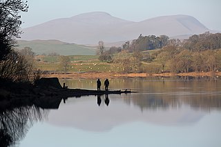
Loch Ken is a 9 miles (14 km) long freshwater loch in the historic county of Kirkcudbrightshire in Dumfries and Galloway, Scotland. It lies in the Glenkens, where it is fed from the north by the Water of Ken and from the west by the Dee. It continues as the Dee south from Glenlochar, where the water is held back by the Glenlochar Barrage. Part of the Galloway hydro-electric power scheme, the barrage regulates the river's flow.
Sorbie is a small village in Wigtownshire, Machars, within the Administration area of Dumfries and Galloway Council, Scotland.

Borgue is a village and parish in the Stewartry of Kirkcudbright in Dumfries and Galloway, Scotland. It lies 5 miles south-west of Kirkcudbright and 6 miles south of Gatehouse of Fleet. The name Borgue is from Old Norse borg 'stronghold'.

Crossmichael is a small village on the east side of Loch Ken in the historical county of Kirkcudbrightshire, about 4 miles (6.4 km) north of Castle Douglas in Scotland.
Penninghame in Wigtownshire, Dumfries and Galloway, Scotland, is a civil parish area, 8 miles from Wigtown. The area is approx 16 miles in length, and from 5 to 6 miles' width, bounded on the north and east by the River Cree, and on the west by the Bladnoch; comprising nearly 38,000 acres, of which 12,000 were arable, 600 woodland and plantations, 1600 meadow, and the remainder hill pasture, moorland, moss, etc.

Colvend and Southwick is a community council area and civil parish within the Stewartry area of Dumfries and Galloway, Scotland. It is also part of the Church of Scotland parish of Colvend, Southwick and Kirkbean. It is in the historic county of Kirkcudbrightshire.

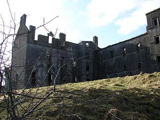
Kenmure Castle is a fortified house or castle in The Glenkens, 1 mile (1.6 km) south of the town of New Galloway in Kirkcudbrightshire, Galloway, south-west Scotland. The site was occupied from the Middle Ages, and the house incorporates part of a 17th-century castle. This was remodelled in the 19th century, but the house has been derelict since the mid-20th century. It was the seat of the Gordon family of Lochinvar, later raised to the peerage as Viscounts of Kenmure. The ruin is a scheduled monument.
Sir John Gordon of Lochinvar and Kenmure, was a Scottish courtier, landowner, and supporter of Mary, Queen of Scots.
James Maitland (1797–1872) was a minister of the Church of Scotland, who served as Moderator of the General Assembly in 1860.


