Kirkcolm

Last updated

Kirkcolm
Blue Peter Hotel, Main Street Kirkcolm - geograph.org.uk - 877791.jpg
Blue Peter Hotel, Main Street, Kirkcolm
Dumfries and Galloway UK location map.svg
Red pog.svg
Kirkcolm
Location within Dumfries and Galloway
OS grid reference NX027686
Council area
Lieutenancy area
Country Scotland
Sovereign state United Kingdom
Post town STRANRAER
Postcode district DG9
Police Scotland
Fire Scottish
Ambulance Scottish
UK Parliament
Scottish Parliament
List of places
UK
Scotland
54°58′26″N5°04′52″W / 54.974°N 5.081°W / 54.974; -5.081

Kirkcolm is a village and civil parish on the northern tip of the Rhinns of Galloway peninsula, south-west Scotland. It is in Dumfries and Galloway, and is part of the former county of Wigtownshire. The parish is bounded on the north and west by the sea, on the east by the bay of Loch Ryan and on the south by Leswalt parish.

Contents

History

The name Kirkcolm is often said – even by local people – to mean the Church of St. Columba. However, the early spellings of the name as Kyrcum (1276), Kirkcum (1397) and Kirkcum (1525) cast doubt on that interpretation, as does the modern local pronunciation which is not Colm with a long 'o', but Cum with a short 'u'. The saint who is actually referred to by the name is mentioned by a papal letter of 1397 as 'St Cummin'. This is the name of more than one Gaelic saint of the early Middle Ages, but the most likely to be commemorated here is Cumméne Find, the seventh abbot of Iona who died in AD 669. The parish has a spring known as the Crosswell, or St. Columba's Well, but this designation first appears after the misunderstanding of the name Kilcolm, so is quite likely to be itself a mistake.

Historically Kirkcolm has seen human activity since ancient times. Sheltered from the rough seas of the North Channel and the North Atlantic, Loch Ryan has long been an important safe harbour for vessels. An Iron Age fort is located at Dunskirkloch on the north coast.

In the spring of 1307, at the beginning of Robert the Bruce's campaign in the Wars of Independence, he sent two forces to attempt to gain control of south-west Scotland. One force, led by his two brothers and consisting of eighteen galleys, landed in Loch Ryan. [1] They were immediately overwhelmed by local forces, led by Dougal MacDougal of Clan MacDowall, a supporter of the Comyns.

The barony of Corsewall was held by Alexander Stewart, Lord Garlies from 1622. [2] It was formerly called Stewarton. [3]

Features of interest

Kilmorie Stone

The Kilmorie cross-slab Kilmorie stone1.jpg
The Kilmorie cross-slab

An Early Medieval cross-slab is located in Kirkcolm churchyard. The cross was removed from the site of Kilmorie Chapel, which was next to St Mary's Well, in the 18th century and built into Kirkcolm church. It was later moved to the grounds of Corsewall House, but re-erected in Kirkcolm churchyard in the 1980s. [4] [5] The designs on cross-slab combine Christian and Norse imagery, reflecting Galloway's Viking and Celtic past. One face of the stone has an elaborately carved cross above a design of intertwined snake-like animals. On the reverse-side is a representation of the Crucifixion. Below is a figure of a man with a pair of tongs and a bird on his shoulder; this may represent Odin or Sigurd. It is thought the carvings on the Kilmorie Stone show the triumph of Christianity over paganism. [6]

Ervie-Kirkcolm Church

The old Parish Church of Kirkcolm, which was in the grounds of Corsewall House, was demolished in 1821 and a new church was built in Kirkcolm, up the hill from the old Kirk. In 1950 Kirkcolm Church of Scotland was united with Ervie Free Church, and in 1985 the church was linked with Leswalt Parish Church. [7] The Kirk session, held in the court of the parish, was made up of the minister and the land owners and business men of the parish and dealt with moral issues, minor criminal cases, matters of the poor and education, matters of discipline, and the general concerns of the parish.

Marian Tower

Marian Hill Monument on Craigengerroch Hill The Marian Hill Monument - geograph.org.uk - 1708623.jpg
Marian Hill Monument on Craigengerroch Hill

Marian Tower is a 19th-century monument on Craigengerroch Hill, around 3 kilometres (1.9 mi) west of Kirkcolm village. There are panoramic views across the Firth of Clyde from this location. [8]

Corsewall Lighthouse

Corsewall Lighthouse stands on the north-west coast of the Rhins, and marks the approach to Loch Ryan. Opened in 1817, the light was automated in 1994 and the rest of the building now operates as a hotel. [9] The lighthouse was built by Robert Stevenson, engineer grandfather of Robert Louis Stevenson, and is a category A listed building. [10]

Corsewall Castle

Remains of Corsewall Castle Remains of Corsewall Castle - geograph.org.uk - 862643.jpg
Remains of Corsewall Castle

Corsewall Castle is a ruined 15th-century tower house to the south-east of the lighthouse. It was owned by Alexander Campbell, a son of Sir Duncan Campbell of Loudoun, whose elder brother Andrew was Sheriff of Ayr. The oblong keep once rose to three storeys and lay on a mound which was protected by a ditch. Now all that remains are the stumps of the four walls, which do not rise beyond a tunnel-vaulted basement. The wall still contains the lower section of a turnpike stair. A small cannon was discovered here in 1791, while a cache of gold coins, silver-plate and jewellery was uncovered in 1802. [11] The castle was forsaken in favour of Corsewall House, near to Kirkcolm village, by the 18th century. A legend recorded in the 19th century states that the castle had a spring of such power that, by raising its lid, the owners could at pleasure flood the moat and approaches to the castle. [12]

Notable people

Admiral Sir John Ross (1777–1856), Arctic explorer, was born in Kirkcolm, the son of the Rev. Andrew Ross of Balsarroch. He joined the Royal Navy aged nine, and served in the Swedish Navy. Between 1818 and 1850 he led three expeditions to explore the North West Passage. He built the North West Castle in Stranraer, where he spent his retirement years. [13] His nephew Admiral Sir James Clark Ross joined him on Arctic expeditions and became the first explorer to reach the North Magnetic Pole in 1831. [14]

David James Speirs (born 15 December 1984) is an Australian politician. He has been a Liberal member of the South Australian House of Assembly since the 2014 state election and leader of the Liberal Party since 19 April 2022. Speirs was born in Galloway, Scotland and raised in Kirkcolm. He was schooled at Kirkcolm Primary School and Stranraer Academy. [15] He emigrated to Australia with his parents and two younger brothers at the age of 17 in 2002. [16]

See also

Related Research Articles

<span class="mw-page-title-main">Dumfries and Galloway</span> Council area of Scotland

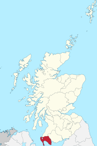
Dumfries and Galloway is one of the 32 unitary council areas of Scotland, located in the western part of the Southern Uplands. It is bordered by East Ayrshire, South Ayrshire, and South Lanarkshire to the north; Scottish Borders to the north-east; the English ceremonial county of Cumbria, the Solway Firth, and the Irish Sea to the south, and the North Channel to the west. The administrative centre and largest settlement is the town of Dumfries. The second largest town is Stranraer, located 76 miles (122 km) to the west of Dumfries on the North Channel coast.

<span class="mw-page-title-main">Stranraer</span> Town and sea port in Scotland

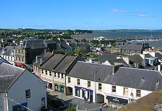
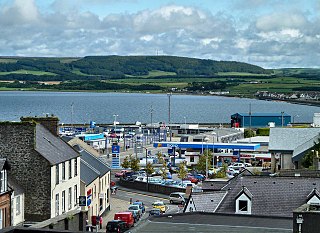
Stranraer, also known as The Toon, is a town in Dumfries and Galloway, Scotland. It is located in the historical parish of Inch in the historic county of Wigtownshire. It lies on the shores of Loch Ryan, on the northern side of the isthmus joining the Rhins of Galloway to the mainland. Stranraer is Dumfries and Galloway's second-largest town, with a population including the immediate surrounding area of nearly 13,000 inhabitants.

<span class="mw-page-title-main">Corsewall Lighthouse</span> Lighthouse in Scotland

Corsewall Lighthouse is a lighthouse at Corsewall Point, Kirkcolm near Stranraer in the region of Dumfries and Galloway in Scotland. First lit in 1817, it overlooks the North Channel of the Irish Sea. The definition of the name Corsewall is the place or well of the Cross.

<span class="mw-page-title-main">Kirkcudbrightshire</span> Historic county in Scotland

Kirkcudbrightshire, or the County of Kirkcudbright or the Stewartry of Kirkcudbright is one of the historic counties of Scotland, covering an area in the south-west of the country. Until 1975, Kirkcudbrightshire was an administrative county used for local government. Since 1975, the area has formed part of Dumfries and Galloway for local government purposes. Kirkcudbrightshire continues to be used as a registration county for land registration. A lower-tier district called Stewartry covered the majority of the historic county from 1975 to 1996. The area of Stewartry district is still used as a lieutenancy area. Dumfries and Galloway Council also has a Stewartry area committee.

<span class="mw-page-title-main">Wigtownshire</span> Historic county in Scotland

Wigtownshire or the County of Wigtown is one of the historic counties of Scotland, covering an area in the south-west of the country. Until 1975, Wigtownshire was an administrative county used for local government. Since 1975 the area has formed part of Dumfries and Galloway for local government purposes. Wigtownshire continues to be used as a territory for land registration, being a registration county. The historic county is all within the slightly larger Wigtown Area, which is one of the lieutenancy areas of Scotland and was used in local government as the Wigtown District from 1975 to 1996.

<span class="mw-page-title-main">Rhins of Galloway</span> Peninsula in Scotland

The Rhinsof Galloway is a double-headed peninsula in southwestern Scotland. It takes the form of a hammerhead projecting into the Irish Sea, terminating in the north at Corsewall and Milleur Points and in the south at the Mull of Galloway. It is connected to the rest of Wigtownshire by an isthmus, washed on the north by Loch Ryan and on the south by Luce Bay. From end to end, the peninsula measures 28 miles. It takes its name from the Gaelic word rinn, meaning "point".

<span class="mw-page-title-main">Dumfries and Galloway (UK Parliament constituency)</span> Parliamentary constituency in the United Kingdom, 2005 onwards

Dumfries and Galloway is a county constituency in the House of Commons of the Parliament of the United Kingdom. It was first used in the 2005 general election, and replaced Galloway and Upper Nithsdale and part of Dumfries. It elects one Member of Parliament (MP) by the first past the post system of election however despite its name, It does not cover the whole of the Dumfries and Galloway Council Area

<span class="mw-page-title-main">Loch Ryan</span> Sea loch in Scottish Lowlands, Scotland

Loch Ryan is a Scottish sea loch that acts as an important natural harbour for shipping, providing calm waters for ferries operating between Scotland and Northern Ireland. The town of Stranraer is the largest settlement on its shores, with ferries to and from Northern Ireland operating from Cairnryan further north on the loch.

Sorbie is a small village in Wigtownshire, Machars, within the Administration area of Dumfries and Galloway Council, Scotland.

<span class="mw-page-title-main">Roman Catholic Diocese of Galloway</span> Roman Catholic diocese in Scotland

The Diocese of Galloway is a Latin Church ecclesiastical territory or diocese of the Catholic Church in Scotland. The pre-Reformation Diocese of Galloway, founded by Ninian in the fifth century, had broken allegiance with Rome in 1560, and disappeared in 1689 in the (official) Church of Scotland but continued in the Episcopal Church of Scotland. The modern Roman Catholic diocese incorporates the local authority areas of Dumfries and Galloway, South Ayrshire, East Ayrshire and parts of North Ayrshire, (Cumbrae). The bishop's cathedra is at St Margaret's Cathedral, Ayr.

Kirkcowan is an area about 15 miles in length, and from nearly two to nearly seven miles in breadth, comprising 30,580 acres, of which 7000 are arable, 300 woodland and plantations, and the remainder meadow, pasture in Machars, in the historical county of Wigtownshire, in Dumfries and Galloway, Scotland, with the village of Kirkcowan, bounded on the east by the river Bladnoch, on the west by the river Tarff, and is 6 miles W. by S.W. from Newton Stewart.

Stoneykirk is an area and a village in the heart of the Rhins of Galloway, Wigtownshire, in the administrative council area of Dumfries and Galloway, Scotland nearly 10 miles (16 km) in length and 3+12 miles (5.6 km) in breadth, bounded on the east by the bay of Luce, and on the west by the Irish Channel, 5 miles (8 km) south of Stranraer.

<span class="mw-page-title-main">Kinneddar</span> Castle in Scotland, United Kingdom

Kinneddar is a small settlement on the outskirts of Lossiemouth in Moray, Scotland, near the main entrance to RAF Lossiemouth. Long predating the modern town of Lossiemouth, Kinneddar was a major monastic centre for the Pictish kingdom of Fortriu from the 6th or 7th centuries, and the source of the important collection of Pictish stones called the Drainie Carved Stones. The Kirk of Kinneddar was the cathedral of the Diocese of Moray between 1187 and 1208, and remained an important centre of diocesan administration and residence of the Bishop of Moray through the 13th and 14th centuries.

<span class="mw-page-title-main">Castle Kennedy</span> Human settlement in Scotland

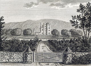
Castle Kennedy is a small village 3 miles (4.8 km) east of Stranraer in Dumfries and Galloway, south-west Scotland. It is on the A75 road, and is within the civil parish of Inch. The village is to the south of the Lochinch Castle estate, which includes the ruins of the 17th-century Castle Kennedy, as well as Castle Kennedy Gardens which are open to the public.

Leswalt is a village and civil parish in Dumfries and Galloway, south-west Scotland. It lies between Portpatrick and Stranraer in the Rhins of Galloway, part of the traditional county of Wigtownshire. The parish covers around 8 square miles (21 km2).

<span class="mw-page-title-main">Inch, Dumfries and Galloway</span> Human settlement in Scotland

Inch is a civil parish in Dumfries and Galloway, southwest Scotland. It lies on the shore of Loch Ryan, in the traditional county of Wigtownshire.

Penninghame in Wigtownshire, Dumfries and Galloway, Scotland, is a civil parish area, 8 miles from Wigtown. The area is approx 16 miles in length, and from 5 to 6 miles' width, bounded on the north and east by the River Cree, and on the west by the Bladnoch; comprising nearly 38,000 acres, of which 12,000 were arable, 600 woodland and plantations, 1600 meadow, and the remainder hill pasture, moorland, moss, etc.

Old Luce is a civil parish in Dumfries and Galloway, Scotland. It lies in the Machars peninsula, in the traditional county of Wigtownshire. The parish is around 10 miles (16 km) long and 8 miles (13 km) broad, and contains 40,350 acres (16,330 ha).

<span class="mw-page-title-main">Stranraer and the Rhins (ward)</span>

Stranraer and the Rhins(Ward 1) is one of the twelve wards used to elect members of Dumfries and Galloway Council in Scotland. It elects four Councillors under the Single Transferable Vote system.

References

  1. "News".
  2. "Stewarton | Canmore".
  3. "Kirkcolm". Gazetteer for Scotland . Retrieved 29 August 2020.
  4. "Kilmorie, Chapel". Canmore. Historic Environment Scotland. Retrieved 7 April 2017.
  5. "Kirkholm, Corsewall House, Cross-slab". Canmore. Historic Environment Scotland. Retrieved 7 April 2017.
  6. "History of the Kilmorie Stone". Ervie-Kirkcolm Church. Archived from the original on 7 April 2017. Retrieved 7 April 2017.
  7. "History of the Kilmorie Stone". Ervie-Kirkcolm Church. Archived from the original on 23 May 2019. Retrieved 7 April 2017.
  8. "Marian Tower". VisitScotland. Retrieved 7 April 2017.
  9. "Corsewall". Northern Lighthouse Board. Retrieved 7 April 2017.
  10. "Corsewall Lighthouse. LB 9923". Historic Environment Scotland. Retrieved 7 April 2017.
  11. "Parish of Kirkcolm from the Gazetteer for Scotland".
  12. The Hereditary Sheriffs of Galloway, by Andrew Agnew. vol. I, p.218 https://archive.org/stream/hereditarysherif01agne#page/218/mode/1up
  13. "Kirkcolm".
  14. Tribute paid to Scots Arctic trio, BBC Scotland News, 12 October 2007.
  15. Speirs, David. "Maiden speech". Archived from the original on 15 July 2014. Retrieved 20 June 2014.
  16. Speirs on election shambles, The Advertiser, 4 February 2023.