An azimuth is the horizontal angle from a cardinal direction, most commonly north, in a local or observer-centric spherical coordinate system.

North is one of the four compass points or cardinal directions. It is the opposite of south and is perpendicular to east and west. North is a noun, adjective, or adverb indicating direction or geography.

The Guardians of the Directions are the deities who rule the specific directions of space according to Hinduism, Jainism and Vajrayāna Buddhism—especially Kālacakra. As a group of eight deities, they are called Aṣṭa-Dikpāla (अष्ट-दिक्पाल), literally meaning guardians of eight directions. They are often augmented with two extra deities for the ten directions, when they are known as the Daśa-Dikpāla. In Hinduism it is traditional to represent their images on the walls and ceilings of Hindu temples. They are also often portrayed in Jain temples, with the exception that Nāga usually takes the place of Vishnu in the nadir. Ancient Java and Bali Hinduism recognize Nava-Dikpāla, literally meaning guardians of nine directions, that consist of eight directions with one addition in the center. The nine guardian gods of directions is called Dewata Nawa Sanga. The diagram of these guardian gods of directions is featured in Surya Majapahit, the emblem of Majapahit empire.

In navigation, bearing or azimuth is the horizontal angle between the direction of an object and north or another object. The angle value can be specified in various angular units, such as degrees, mils, or grad. More specifically:

A compass rose or compass star, sometimes called a wind rose or rose of the winds, is a polar diagram displaying the orientation of the cardinal directions and their intermediate points. It is used on compasses, maps, or monuments. It is particularly common in navigation systems, including nautical charts, non-directional beacons (NDB), VHF omnidirectional range (VOR) systems, satellite navigation devices ("GPS").

The Earthly Branches are a system of twelve ordered symbols used throughout East Asia. They are indigenous to China, and are themselves Chinese characters, corresponding to words with no concrete meaning other than the associated branch's ordinal position in the list. Cultural applications of the Branches include a dating system known as the sexagenary cycle, as well as astrology. They are associated with the ten Heavenly Stems in Chinese calendars, and in Taoist practice.
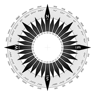
The points of the compass are a set of horizontal, radially arrayed compass directions used in navigation and cartography. A compass rose is primarily composed of four cardinal directions—north, east, south, and west—each separated by 90 degrees, and secondarily divided by four ordinal (intercardinal) directions—northeast, southeast, southwest, and northwest—each located halfway between two cardinal directions. Some disciplines such as meteorology and navigation further divide the compass with additional azimuths. Within European tradition, a fully defined compass has 32 "points".
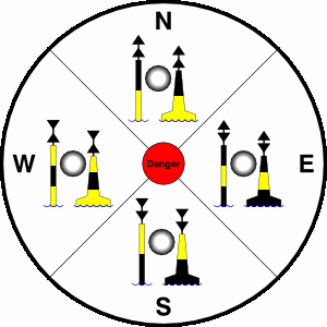
A cardinal mark is a sea mark commonly used in maritime pilotage to indicate the position of a hazard and the direction of safe water.
Northeast is a compass point.
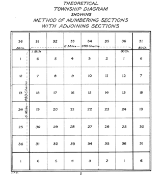
In U.S. land surveying under the Public Land Survey System (PLSS), a section is an area nominally one square mile, containing 640 acres, with 36 sections making up one survey township on a rectangular grid.

A day beacon is an unlighted nautical sea mark. A signboard identifying it is called a day mark. Day beacons typically mark channels whose key points are marked by lighted buoys. They may also mark smaller navigable routes in their entirety. They are the most common navigation aid in shallow water, as they are relatively inexpensive to install and maintain. Navigation around them is similar to that around other navigation aids.
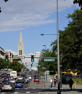
The oldest part of Denver, Colorado, now the neighborhoods of Auraria Campus, LoDo, much of downtown, and Five Points, is laid out on a grid plan that is oriented diagonal to the four cardinal directions. The rest of the city, including the eastern part of downtown, is laid out primarily on a grid oriented to the cardinal directions. In this larger grid, from east to west, there are generally 16 city blocks per mile, except between Zuni Street and Lowell Boulevard in west Denver. From north to south, there are typically eight blocks per mile, although there are many areas with more blocks per mile. Addresses follow a decimal system, with addresses advancing by one hundred at each cross street.

Pennsylvania Route 819 is a 46.6-mile-long (75.0 km) state highway located in Fayette and Westmoreland counties in Pennsylvania, United States. The southern terminus is at PA 201 in Vanderbilt. The northern terminus is at PA 66 in Oklahoma.

Sun path, sometimes also called day arc, refers to the daily and seasonal arc-like path that the Sun appears to follow across the sky as the Earth rotates and orbits the Sun. The Sun's path affects the length of daytime experienced and amount of daylight received along a certain latitude during a given season.

Astrolabe Island is an island 3 nautical miles long, lying in the Bransfield Strait 14 nautical miles northwest of Cape Ducorps, Trinity Peninsula in Antarctica.

The Rayleigh sky model describes the observed polarization pattern of the daytime sky. Within the atmosphere, Rayleigh scattering of light by air molecules, water, dust, and aerosols causes the sky's light to have a defined polarization pattern. The same elastic scattering processes cause the sky to be blue. The polarization is characterized at each wavelength by its degree of polarization, and orientation.

In the ancient Mediterranean world, the classical compass winds were names for the points of geographic direction and orientation, in association with the winds as conceived of by the ancient Greeks and Romans. Ancient wind roses typically had twelve winds and thus twelve points of orientation, sometimes reduced to eight or increased to twenty-four.
There are four seas in the world that are named in English after common color names, although most look blue. The names are: The Red Sea, White Sea, Black Sea, and Yellow Sea. Their names are given by the color of the water. Sometimes a system of color symbolism was used as the following method green or light blue for east, black or dark for north, white for west, and red for south. This method is called cardinal directions. There are other theories but these two methods of colors are also used.
Direction determination refers to the ways in which a cardinal direction or compass point can be determined in navigation and wayfinding. The most direct method is using a compass, but indirect methods exist, based on the Sun path, the stars, and satellite navigation.