
Mounted orienteering is the practice of orienteering while riding a horse or other riding animal.
Mounted orienteering is the practice of orienteering while riding a horse or other riding animal.
Mounted orienteering was an important function of cavalry units and today remains an important skill for mounted search and rescue.
Mounted orienteering can be completed competitively, either as a discipline in its own right, or as part of a multi-discipline sport such as Trec. The rules between governing bodies vary widely, although all require horsemanship and the ability to read a map and use a compass.
There are significant differences between mounted orienteering rules and those set down for foot orienteering by the International Orienteering Federation. Differences concern the map, course, route choice, and control points. Both sports use available maps, usually but not necessarily topographic maps. These maps generally are not appropriate for teaching beginning competitors to use the more advanced skills of field navigation. Hence, the required navigational skills are kept simple. [1]
American (NACMO) mounted orienteering competitions resemble rogaining in that courses are long and competitors choose the order in which to seek control points, and resemble treasure hunting or fox Oring in that once in the vicinity of a control point the task is to search for (rather than navigate to) a landmark and from there follow a compass heading to the control point. The landmark is described on a clue sheet, and often is not a feature on the map; e.g., the landmark might be a tree of a noted species and size, perhaps marked in some way for the competition. There will be several landmarks in the vicinity of the control point, usually on trails. The intent is to permit competitors who find more than one landmark to use them to triangulate the location of the control point on their map, then ride by the most efficient route directly to the control point.
In Europe, there is little mounted orienteering as a stand-alone sport, although there are significant elements present in endurance riding and as a specific event in the multi-discipline sport of Trec.
Motorcycle sport is a broad field that encompasses all sporting aspects of motorcycling. The disciplines are not all races or timed-speed events, as several disciplines test a competitor's various riding skills.

Orienteering is a group of sports that involve using a map and compass to navigate from point to point in diverse and usually unfamiliar terrain whilst moving at speed. Participants are given a topographical map, usually a specially prepared orienteering map, which they use to find control points. Originally a training exercise in land navigation for military officers, orienteering has developed many variations. Among these, the oldest and the most popular is foot orienteering. For the purposes of this article, foot orienteering serves as a point of departure for discussion of all other variations, but almost any sport that involves racing against a clock and requires navigation with a map is a type of orienteering.

Equestrianism, commonly known as horse riding or horseback riding, includes the disciplines of riding, driving, and vaulting. This broad description includes the use of horses for practical working purposes, transportation, recreational activities, artistic or cultural exercises, and competitive sport.

Adventure racing is typically a multidisciplinary team sport involving navigation over an unmarked wilderness course with races extending anywhere from two hours up to two weeks in length. Some races offer solo competitions as well. The principal disciplines in adventure racing include trekking, mountain biking, and paddling although races can incorporate a multitude of other disciplines including climbing, abseiling, horse riding, skiing and white water rafting. Teams generally vary in gender mix and in size from two to five competitors, however, the premier format is considered to be mixed-gender teams of four racers. There is typically no suspension of the clock during races, irrespective of length; elapsed competition time runs concurrently with real-time, and competitors must choose if or when to rest.

TREC, short for the French Techniques de Randonnée Équestre de Compétition is an equestrian discipline designed to test horse and rider. With origins in France, the sport has spread through Europe, and was introduced to the UK by the British Horse Society (BHS) in 1998. The sport is now known as British TREC and is run by TREC GB. TREC competitions consist of three separate events (phases) - mounted orienteering, a demonstration of control of the horse's paces and an obstacle course - all completed over the course of one or two days, and points scored, with the highest scoring being declared the overall event winner.

Mountain bike racing is the competitive cycle sport discipline of mountain biking held on off-road terrain. The Union Cycliste Internationale (UCI) recognised the discipline relatively late in 1990, when it sanctioned the world championships in Durango, Colorado. The first UCI Mountain Bike World Cup series took place in 1988. Its nine-race circuit covered two continents—Europe and North America—and was sponsored by Grundig. Cross-country racing was the only World Cup sport at this time. In 1993, a six-event downhill World Cup was introduced. In 1996, cross-country mountain biking events were added to the Olympic Games. In 2006, cross-country mountain biking events became part of the World Deaf Cycling Championships for the first time in San Francisco, USA.

Amateur radio direction finding is an amateur racing sport that combines radio direction finding with the map and compass skills of orienteering. It is a timed race in which individual competitors use a topographic map, a magnetic compass and radio direction finding apparatus to navigate through diverse wooded terrain while searching for radio transmitters. The rules of the sport and international competitions are organized by the International Amateur Radio Union. The sport has been most popular in Eastern Europe, Russia, and China, where it was often used in the physical education programs in schools.

Diver navigation, termed "underwater navigation" by scuba divers, is a set of techniques—including observing natural features, the use of a compass, and surface observations—that divers use to navigate underwater. Free-divers do not spend enough time underwater for navigation to be important, and surface supplied divers are limited in the distance they can travel by the length of their umbilicals and are usually directed from the surface control point. On those occasions when they need to navigate they can use the same methods used by scuba divers.

Land navigation is the discipline of following a route through unfamiliar terrain on foot or by vehicle, using maps with reference to terrain, a compass, and other navigational tools. It is distinguished from travel by traditional groups, such as the Tuareg across the Sahara and the Inuit across the Arctic, who use subtle cues to travel across familiar, yet minimally differentiated terrain.
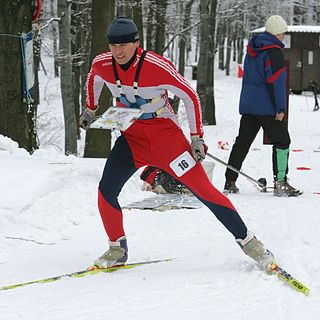
Ski orienteering (SkiO) is a cross-country skiing endurance winter racing sport and one of the four orienteering disciplines recognized by the IOF. A successful ski orienteer combines high physical endurance, strength and excellent technical skiing skills with the ability to navigate and make the best route choices while skiing at a high speed.
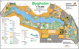
An orienteering map is a map specially prepared for use in orienteering events. It is a large-scale topographic map with extra markings to help the participant navigate through the course.

Trail orienteering (TrailO) is an orienteering sport that involves precise reading of an orienteering map and the corresponding terrain. Trail orienteers must identify, in the terrain and in the presence of decoys, control points shown on the map. TrailO involves navigation skills but unlike most other forms of orienteering, it involves no point to point racing and little or no route choice. It is conducted usually on trails and because the objective is accuracy, not the speed of physical movement, the sport is accessible to physically disabled competitors on equal terms as able-bodied.
Underwater sports is a group of competitive sports using one or a combination of the following underwater diving techniques - breath-hold, snorkelling or scuba, usually including the use of equipment such as diving masks and fins. These sports are conducted in the natural environment at sites such as open water and sheltered or confined water such as lakes and in artificial aquatic environments such as swimming pools. Underwater sports include the following - aquathlon, finswimming, freediving, spearfishing, sport diving, underwater football, underwater hockey, underwater ice hockey, underwater orienteering, underwater photography, underwater rugby, underwater target shooting and underwater video.
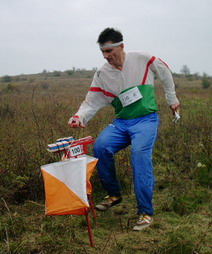
A control point is a marked waypoint used in orienteering and related sports such as rogaining and adventure racing. It is located in the competition area; marked both on an orienteering map and in the terrain, and described on a control description sheet. The control point must be identifiable on the map and on the ground. A control point has three components: a high visibility item, known as a flag or kite; an identifier, known as a control code; and a recording mechanism for contestants to record proof that they visited the control point. The control point is usually temporary, except on a permanent orienteering course.
Route choice is a tactic in orienteering and related sports such as rogaining and adventure racing. These sports involve navigation from one control point to the next and, in most cases, the choice of route is left to the competitor. This is provided the rules permit route choice and the course is designed so that a choice exists. In trail orienteering and European style mounted orienteering route choice is not permitted. In United States style foot orienteering, route choice is absent from White courses, limited in Yellow courses, and a crucial element in the design of more advanced courses. Given a choice of route, the competitor evaluates trade-offs among such factors as distance, amount of "climb", degree and extent of "fight", mode of travel, technical difficulty, and the competitor's own preferences.

Mountain bike orienteering is an orienteering endurance racing sport on a mountain bike where navigation is done along trails and tracks. Compared with foot orienteering, competitors usually are not permitted to leave the trail and track network. Navigation tactics are similar to ski-orienteering, where the major focus is route choice while navigating. The main difference compared to ski-orienteering is that navigation is done at a higher pace, because the bike can reach higher speeds. As the biker reaches higher speeds, map reading becomes more challenging.

An orienteering course is composed of a start point, a series of control points, and a finish point. Controls are marked with a white and orange flag in the terrain, and corresponding purple symbols on an orienteering map. The challenge is to complete the course by visiting all control points in the shortest possible time, aided only by the map and a compass.

Canoe orienteering (canoe-O) is an orienteering sport using a canoe, kayak, or other small boat. Usually, a canoe-O is a timed race in which one- or two-person boats start at staggered intervals, are timed, and are expected to perform all navigation on their own. Portages are allowed. The control points, shown on an orienteering map, may be visited in any order. Standings are determined first by successful completion of the course, then by shortest time on course.
Foot orienteering is the oldest formal orienteering sport, and the one with the most "starts" per year. Usually, a FootO is a timed race in which participants start at staggered intervals, are individually timed, and are expected to perform all navigation on their own. The control points are shown on the orienteering map and must be visited in the specified order. Standings are determined first by successful completion of the course, then by shortest time on course.
Underwater orienteering is an underwater sport that uses recreational open circuit scuba diving equipment and consists of a set of individual and team events conducted in both sheltered and open water testing the competitors' competency in underwater navigation. The competition is principally concerned with the effectiveness of navigation technique used by competitors to swim an underwater course following a route marked on a map prepared by the competition organisers, a compass and a counter meter to measure the distance covered. The sport was developed in the Soviet Union during the late 1950s and is played mainly in Europe. It is known as Orientation Sub in French and as La Orientación Subacuática in Spanish. Historically, the sport has also been known as Technical Disciplines.
| Sport disciplines |
| ||||||||
|---|---|---|---|---|---|---|---|---|---|
| Equipment |
| ||||||||
| Software |
| ||||||||
| Video games | |||||||||
| Fundamentals | |||||||||
| Organisations / lists | |||||||||
| Non-sport related | |||||||||
| Competitions |
| ||||||||
 | This article about equestrian sports or equestrianism is a stub. You can help Wikipedia by expanding it. |