Before 1400

- Anaximander, Greek Anatolia (610 BC–546 BC), first to attempt making a map of the known world
- Hecataeus of Miletus, Greek Anatolia (550 BC–476 BC), geographer, cartographer, and early ethnographer
- Dicaearchus, Magna Graecia (c. 350 BC–285 BC), philosopher, cartographer, geographer, mathematician, author
- Ende, Spain (c. 1000 AD), illustrator, cartographer, nun
- Eratosthenes, Ptolemaic Egypt (276 BC–194 BC), Greek scientist, mathematician, geographer, and cartographer
- Gyōki, Japan (668–749), Buddhist monk, cartographer, surveyor, and civil engineer,
- Hipparchus, Greek Anatolia (190 BC–120 BC), astronomer, cartographer, geographer
- Liu An, China (179 BC–122 BC), geographer, cartographer, author of the Huainanzi
- Marinus of Tyre, Roman Syria (c. AD 70–130), Greek [1] geographer, cartographer and mathematician, who founded mathematical geography
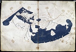
- Ptolemy, Ptolemaic Egypt (c. 85–165), Greek astronomer, cartographer, and geographer
- Pei Xiu (224–271), Chinese geographer and cartographer
- Isidore of Seville, Hispania (560–636)
- al-Khwārazmī, Caliphate (9th century), Persian cartographer, geographer, and polymath.
- Su Song, China (1020–1101), horologist and engineer; as a Song dynasty diplomat, he used his knowledge of cartography and map-making to solve territorial border disputes with the rival Liao dynasty
- Shen Kuo, China (1031–1095), polymath scientist and statesman, author of the Dream Pool Essays , which included a large atlas of China and foreign regions, and also made a three-dimensional raised-relief map
- al-Idrisi, Sicily (1100–1166), Arab cartographer, geographer and traveller
- Maximus Planudes, Byzantine Empire (13th century), a monk credited with restoring the texts and maps of Ptolemy
- Petrus Vesconte, Genoese cartographer, author of the oldest signed Portolan chart (1311)
- Angelino Dulcert (14th century), author of the earliest known Majorcan portolan charts of the Mediterranean


