
The history of the Kingdom of Portugal from the Illustrious Generation of the early 15th century to the fall of the House of Aviz in the late 16th century has been named the "Portuguese golden age" and the "Portuguese Renaissance". During this period, Portugal was the first European power to begin building a colonial empire as during the Age of Exploration Portuguese sailors and explorers discovered an eastern route to India as well as several Atlantic archipelagos and colonized the African coast and Brazil. They also explored the Indian Ocean and established trading routes throughout most of southern Asia, sending the first direct European maritime trade and diplomatic missions to Ming China and to Japan, at the same time installing trading posts and the most important colony: Portuguese Macau. The Portuguese Renaissance produced a plethora of poets, historians, critics, theologians, and moralists. The Cancioneiro Geral by Garcia de Resende is taken to mark the transition from Old Portuguese to the modern Portuguese language.

Terra Australis was a hypothetical continent first posited in antiquity and which appeared on maps between the 15th and 18th centuries. Its existence was not based on any survey or direct observation, but rather on the idea that continental land in the Northern Hemisphere should be balanced by land in the Southern Hemisphere. This theory of balancing land has been documented as early as the 5th century on maps by Macrobius, who uses the term Australis on his maps.
This article presents lists of the literary events and publications in 1519.

Conquistadors or conquistadores was a term used to refer to Spanish and Portuguese colonialists of the early modern period. During the Age of Discovery, conquistadors sailed beyond Iberian Peninsula to the Americas, Oceania, Africa and Asia, establishing new colonies and trade routes. They brought much of the "New World" under the dominion of Spain and Portugal.

The Cantino planisphere or Cantino world map is a manuscript Portuguese world map preserved at the Biblioteca Estense in Modena, Italy. It is named after Alberto Cantino, an agent for the Duke of Ferrara, who successfully smuggled it from Portugal to Italy in 1502. It measures 220 x 105 cm.

Duarte Barbosa was a Portuguese writer and officer from Portuguese India. He was a scrivener in a feitoria in Kochi, and an interpreter of the local language, Malayalam. Barbosa wrote the Book of Duarte Barbosa c. 1516, making it one of the earliest examples of Portuguese travel literature.

Duarte Pacheco Pereira, called the Portuguese Achilles by the poet Camões, was a Portuguese sea captain, soldier, explorer and cartographer. He travelled particularly in the central Atlantic Ocean west of the Cape Verde islands, along the coast of West Africa and to India. His accomplishments in strategic warfare, exploration, mathematics and astronomy were of an exceptional level.

The Dieppe maps are a series of world maps and atlases produced in Dieppe, France, in the 1540s, 1550s, and 1560s. They are large hand-produced works, commissioned for wealthy and royal patrons, including Kings Henry II of France and Henry VIII of England. The Dieppe school of cartographers included Pierre Desceliers, Jean Rotz, Guillaume Le Testu, Guillaume Brouscon and Nicolas Desliens.
Jorge Reinel born in Lisbon was a Portuguese cartographer and instructor in cartography, son of the well-known cartographer Pedro Reinel. In 1519 in Seville he participated in the maps designed for the trip of his countryman Ferdinand Magellan, and his depiction of the Maluku Islands served as a basis for Spanish claims to the islands. He had trained many pupils in the art of cartography such as Portuguese Diogo Ribeiro.

Pedro Reinel was a Portuguese cartographer. Between 1485 and 1519 Reinel served three Portuguese kings: João II, Manuel I and João III. He and his son, Jorge Reinel, were among the most renowned cartographers of their era, a period when European knowledge of geography and cartography were expanding rapidly. There is some evidence he was of African descent. Historian Rafael Moreira believes Reinel's father was an ivory carver brought from West Africa to serve in the royal workshops.
The Johannes Schöner globes are a series of globes made by Johannes Schöner (1477–1547), the first being made in 1515. Schöner's globes are some of the oldest still in existence. Some of them are said by some authors to show parts of the world that were not yet known to Europeans, such as the Magellan Strait and the Antarctic.

Portuguese maritime exploration resulted in the numerous territories and maritime routes recorded by the Portuguese as a result of their intensive maritime journeys during the 15th and 16th centuries. Portuguese sailors were at the vanguard of European exploration, chronicling and mapping the coasts of Africa and Asia, then known as the East Indies, and Canada and Brazil, in what came to be known as the Age of Discovery.
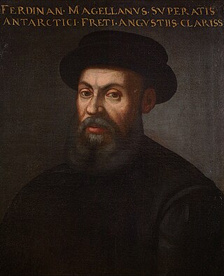
Ferdinand Magellan was a Portuguese explorer best known for having planned and led the 1519 Spanish expedition to the East Indies across the Pacific Ocean to open a maritime trade route, during which he discovered the interoceanic passage thereafter bearing his name and achieved the first European navigation to Asia via the Pacific. After his death, this expedition was the first to circumnavigate the globe in 1519–22 in the service of Spain.

The Treaty of Zaragoza or Saragossa, also called the Capitulation of Zaragoza or Saragossa, was a peace treaty between Castile and Portugal, signed on 22 April 1529 by King John III of Portugal and the Habsburg emperor Charles V in the Aragonese city of Zaragoza. The treaty defined the areas of Castilian and Portuguese influence in Asia in order to resolve the "Moluccas issue", which had arisen because both kingdoms claimed the lucrative Spice Islands for themselves, asserting that they were within their area of influence as specified in 1494 by the Treaty of Tordesillas. The conflict began in 1520, when expeditions from both kingdoms reached the Pacific Ocean, because no agreed meridian of longitude had been established in the far east.

Lopo Homem was a 16th-century Portuguese cartographer and cosmographer based in Lisbon and best known for his work on the Miller Atlas.

The Seventh India Armada was assembled in 1505 on the order of King Manuel I of Portugal and placed under the command of D. Francisco de Almeida, the first Portuguese Viceroy of the Indies. The 7th Armada set out to secure the dominance of the Portuguese navy over the Indian Ocean by establishing a series of coastal fortresses at critical points – Sofala, Kilwa, Anjediva, Cannanore – and reducing cities perceived to be local threats.
The high office of Admiral of the Kingdom of Portugal as the head of the Portuguese navy was created by King Denis of Portugal in 1317 for the Genoese nobleman and naval officer Manuel Pessanha. Although there is evidence that such a title existed before, it seems to have been of only a temporary character, for fleets assembled in times of war. The exception was perhaps Nuno Fernandes Cogominho who seems to have been appointed admiral by King Denis in 1307, and still had that title at his death in 1316, although the conditions are unclear. Nonetheless, Manuel Pessanha was the first person known to hold the title of Almirante-mor as a permanent office for a permanent fleet. All the king's galleys were under his jurisdiction. The conditions of the Pessanha's title stipulated that he must maintain a corps of at least 20 Genoese naval officers at all times and was obliged to serve the king in military service on land as well as sea.

The Portuguese Renaissance refers to the cultural and artistic movement in Portugal during the 15th and 16th centuries. Though the movement coincided with the Spanish and Italian Renaissances, the Portuguese Renaissance was largely separate from other European Renaissances and instead was extremely important in opening Europe to the unknown and bringing a more worldly view to those European Renaissances, as at the time the Portuguese Empire spanned the globe.
Portuguese nautical science evolved from the successive expeditions and experience of the Portuguese pilots. It led to a fairly rapid evolution, creating an elite of astronomers, navigators, mathematicians and cartographers. Among them stood Pedro Nunes with studies on how to determine latitude by the stars, and João de Castro, who made important observations of magnetic declination over the entire route around Africa.

