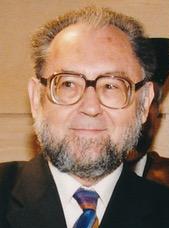
Roger Brunet (born March 30, 1931) [1] is a French geographer.
Roger Brunet (born March 30, 1931) [1] is a French geographer.
Born in Toulouse, Brunet attended the University of Toulouse, where he earned his PhD in 1965. He was subsequently professor at the University of Reims from 1966 to 1976, where he founded IATEUR. He was a director of research at CNRS from 1976 to 1981, and from 1981 to 1984 served advisory and research roles in various French government ministries. In 1984, he founded the public interest group RECLUS, which he headed until 1991. [2]
In the early 1970s, Brunet emerged as a leader in a movement to give academic geography a bigger role in practical issues, such as urban planning policies and secondary-school geography curricula, and founded the journal L'Espace géographique in 1972. [3]
He was particularly associated with the development of the chorem, a cartographic approach to representing complex geographic information (including human geography) using a simplified set of spatial primitives. [3] Chorems gained significant adoption in geography education, but also drew critics for allegedly oversimplifying and focusing too strongly on spatial representation. [3] [4] This cartographic approach to geography was, from the early 1980s, a rival to Yves Lacoste's geopolitical approach. Brunet founded the cartographic geography journal Mappemonde in 1986, which in turn was a rival to Lacoste's Hérodote . [4]
In the popular press, the "blue banana" is one of his best-known productions. Developed in 1989 as part of a study overseen by Brunet that aimed to study French territory in its contemporary European context, the concept proposed that the backbone of Europe was formed by a curved axis of highly urbanized regions that bypassed France. [5]

Human geography or anthropogeography is the branch of geography which studies spatial relationships between human communities, cultures, economies, and their interactions with the environment, examples of which include urban sprawl and urban redevelopment. It analyzes spatial interdependencies between social interactions and the environment through qualitative and quantitative methods. This multidisciplinary approach draws from sociology, anthropology, economics, and environmental science, contributing to a comprehensive understanding of the intricate connections that shape lived spaces.
Social geography is the branch of human geography that is interested in the relationships between society and space, and is most closely related to social theory in general and sociology in particular, dealing with the relation of social phenomena and its spatial components. Though the term itself has a tradition of more than 100 years, there is no consensus on its explicit content. In 1968, Anne Buttimer noted that "[w]ith some notable exceptions, (...) social geography can be considered a field created and cultivated by a number of individual scholars rather than an academic tradition built up within particular schools". Since then, despite some calls for convergence centred on the structure and agency debate, its methodological, theoretical and topical diversity has spread even more, leading to numerous definitions of social geography and, therefore, contemporary scholars of the discipline identifying a great variety of different social geographies. However, as Benno Werlen remarked, these different perceptions are nothing else than different answers to the same two questions, which refer to the spatial constitution of society on the one hand, and to the spatial expression of social processes on the other.

A geographer is a physical scientist, social scientist or humanist whose area of study is geography, the study of Earth's natural environment and human society, including how society and nature interacts. The Greek prefix "geo" means "earth" and the Greek suffix, "graphy", meaning "description", so a geographer is someone who studies the earth. The word "geography" is a Middle French word that is believed to have been first used in 1540.
Geopolitics is the study of the effects of Earth's geography on politics and international relations. Geopolitics usually refers to countries and relations between them, it may also focus on two other kinds of states: de facto independent states with limited international recognition and relations between sub-national geopolitical entities, such as the federated states that make up a federation, confederation, or a quasi-federal system.
Economic geography is the subfield of human geography that studies economic activity and factors affecting it. It can also be considered a subfield or method in economics.

Geomatics is defined in the ISO/TC 211 series of standards as the "discipline concerned with the collection, distribution, storage, analysis, processing, presentation of geographic data or geographic information". Under another definition, it consists of products, services and tools involved in the collection, integration and management of geographic (geospatial) data. Surveying engineering was the widely used name for geomatic(s) engineering in the past. Geomatics was placed by the UNESCO Encyclopedia of Life Support Systems under the branch of technical geography.
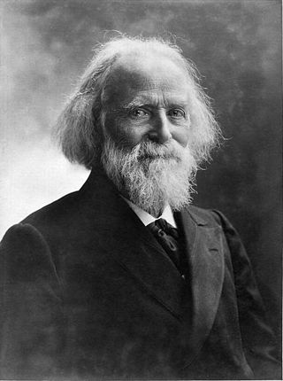
Jacques Élisée Reclus was a French geographer, writer and anarchist. He produced his 19-volume masterwork, La Nouvelle Géographie universelle, la terre et les hommes, over a period of nearly 20 years (1875–1894). In 1892 he was awarded the Gold Medal of the Paris Geographical Society for this work, despite having been banished from France because of his political activism.
The History of geography includes many histories of geography which have differed over time and between different cultural and political groups. In more recent developments, geography has become a distinct academic discipline. 'Geography' derives from the Greek γεωγραφία – geographia, literally "Earth-writing", that is, description or writing about the Earth. The first person to use the word geography was Eratosthenes. However, there is evidence for recognizable practices of geography, such as cartography, prior to the use of the term.

Yves Lacoste, is a French geographer, known for his political commitment and contributions to geopolitics. Born in Rabat, Morocco, the son of a geologist, Jean Lacoste, and a librarian, he spent his childhood in the city before continuing his secondary education at the Lycée Lakanal in Sceaux (Seine) and his higher education at the Sorbonne.
In the humanities discipline of critical theory, critical geopolitics is an academic school of thought centered on the idea that intellectuals of statecraft construct ideas about places, that these ideas have influence and reinforce their political behaviors and policy choices, and that these ideas affect how people process their own notions of places and politics.

The Blue Banana, also known as the European Megalopolis or the Liverpool–Milan Axis, is a discontinuous corridor of urbanization in Western and Central Europe, with a population of around 100 million. Over time, the region has been referred to by several names, each reflecting its development and significance. Initially, French geographer Roger Brunet, as the leader of RECLUS, described the area as 'the European Backbone', which depicted an urban corridor extending from Liverpool to Milan. Characterized by significant industrialization and urbanization, this area has attracted numerous public and private enterprises since the early post-war period, prompting researchers and academics to investigate the factors behind its remarkable development within Europe. It stretches approximately from North West England through the English Midlands across Greater London to the European Metropolis of Lille, the Benelux states with the Dutch Randstad and Brussels and along the German Rhineland, Southern Germany, Alsace-Moselle in France in the west and Switzerland, Austria to Northern Italy in the south.
Geography is the study of the lands, features, inhabitants, and phenomena of Earth. Geography is an all-encompassing discipline that seeks an understanding of Earth and its human and natural complexities—not merely where objects are, but also how they have changed and come to be. While geography is specific to Earth, many concepts can be applied more broadly to other celestial bodies in the field of planetary science. Geography has been called "a bridge between natural science and social science disciplines."
Geocriticism is a method of literary analysis and literary theory that incorporates the study of geographic space. The term designates a number of different critical practices. In France, Bertrand Westphal has elaborated the concept of géocritique in several works. In the United States, Robert Tally has argued for a geocriticism as a critical practice suited to the analysis of what he has termed "literary cartography".

The following outline is provided as an overview of and topical guide to geography:
Spatial contextual awareness consociates contextual information such as an individual's or sensor's location, activity, the time of day, and proximity to other people or objects and devices. It is also defined as the relationship between and synthesis of information garnered from the spatial environment, a cognitive agent, and a cartographic map. The spatial environment is the physical space in which the orientation or wayfinding task is to be conducted; the cognitive agent is the person or entity charged with completing a task; and the map is the representation of the environment which is used as a tool to complete the task.
The History of Cartography Project is a publishing project in the Department of Geography at the University of Wisconsin–Madison. It was founded by David Woodward in 1981. Woodward directed the project until his death in August 2004; Matthew H. Edney became director in July 2005.
RECLUS is a public interest group founded in 1984, associated to the Maison de la géographie de Montpellier. The acronym translates to "Network for the study of changes in the locations and the spatial units" and was coined as a tribute to Élisée Reclus, the 19th-century French geographer, author of the New Universal Geography, a treatise in 19 volumes, published by Hachette, between 1876 and 1894. One of the most important ideas of Reclus is indeed the trans-boundary region, which is retaken by Roger Brunet, the founder of the RECLUS group and its director until 1991, in order to formulate the concept of the European Megalopolis. Hérvé Théry was a Director of the institute
Jacques Lévy is a professor of geography and urbanism at the School of Architecture, Civil and Environmental Engineering of the École Polytechnique Fédérale de Lausanne (EPFL). He is the director of Chôros Laboratory and of the Doctoral Program in Architecture and Science of the City. He is the cofounder of the scientific journal EspacesTemps.net. He published in French, along with Michel Lussault, the dictionary of geography and space of societies, Dictionnaire de la géographie et de l’espace des sociétés.He has contributed to in the epistemological and theoretical reform of geography as a science of the spatial dimension of the social, open to the social sciences and philosophy. Starting from political geography, he has most notably explored the city, urbanity, Europe and globalization. He works also for the introduction of non-verbal languages, especially audio-visual languages, at all levels of research. In 2013 he made a feature film, Urbanity/ies, which is intended as a manifesto for scientific film.
Technical geography is the branch of geography that involves using, studying, and creating tools to obtain, analyze, interpret, understand, and communicate spatial information.
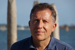
Hervé Théry is a French and Brazilian internationally renowned geographer. A specialist in Brazilian territorial dynamics, his research focuses on topics such as pioneer agricultural fronts, ecological tensions, and thematic cartography.
| International | |
|---|---|
| National | |
| Academics | |
| People | |
| Other | |