
Cartography is the study and practice of making and using maps. Combining science, aesthetics and technique, cartography builds on the premise that reality can be modeled in ways that communicate spatial information effectively.

The Royal Geographical Society , often shortened to RGS, is a learned society and professional body for geography based in the United Kingdom. Founded in 1830 for the advancement of geographical sciences, the Society has 16,000 members, with its work reaching the public through publications, research groups and lectures.

Waldo Rudolph Tobler was an American-Swiss geographer and cartographer. Tobler's idea that "Everything is related to everything else, but near things are more related than distant things" is referred to as the "first law of geography." He has proposed a second law as well: "The phenomenon external to an area of interest affects what goes on inside". Tobler was an active Professor Emeritus at the University of California, Santa Barbara Department of Geography until his death.

Augustus Heinrich Petermann was a German cartographer.

Mount Gongga, also known as Minya Konka and colloquially as "The King of Sichuan Mountains", is the highest mountain in Sichuan province, China. It has an elevation of 7,556 m (24,790 ft) above sea level. This makes it the third highest peak in the world outside of the Himalaya/Karakoram range, after Tirich Mir and Kongur Tagh, and the easternmost 7,000-metre (23,000 ft) peak in the world. It is situated in the Daxue Shan mountain range, between Dadu River and Yalong River, and is part of the Hengduan mountainous region. From it comes the Hailuogou glacier.
Collins Bartholomew, formerly John Bartholomew and Son, is a long-established map publishing company originally based in Edinburgh, Scotland. It is now a subsidiary of HarperCollins.

Alexander Keith Johnston FRSE FRGS FGS FEGS LLD was a Scottish geographer and cartographer.

John George Bartholomew was a Scottish cartographer and geographer. As a holder of a royal warrant, he used the title "Cartographer to the King"; for this reason he was sometimes known by the epithet "the Prince of Cartography".
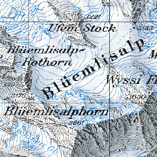
The cartography of Switzerland is the history of surveying and creation of maps of Switzerland. Switzerland has had its current boundaries since 1815, but maps of the Old Swiss Confederacy were drawn since the 16th century. The first topographical survey on a federal level began in 1809, resulting in the Topographic Map of Switzerland or Dufour Map. From 1869 to 1901, this map was replaced by the Topographic Atlas of Switzerland or Siegfried Map.

John Arrowsmith (1790–1873) was an English cartographer. He was born at Winston, County Durham, England. He was the nephew of Aaron Arrowsmith, another English cartographer.

Terrain cartography or relief mapping is the depiction of the shape of the surface of the Earth on a map, using one or more of several techniques that have been developed. Terrain or relief is an essential aspect of physical geography, and as such its portrayal presents a central problem in cartographic design, and more recently geographic information systems and geovisualization.
The International Cartographic Association (ICA), is an organization formed of national member organizations, to provide a forum for issues and techniques in cartography and geographic information science (GIScience). ICA was founded on June 9, 1959, in Bern, Switzerland. The first General Assembly was held in Paris in 1961. The mission of the International Cartographic Association is to promote the disciplines and professions of cartography and GIScience in an international context. To achieve these aims, the ICA works with national and international governmental and commercial bodies, and with other international scientific societies.
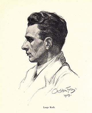
Lauge Koch was a Danish geologist and Arctic explorer.

Hachures are an older mode of representing relief. They show orientation of slope, and by their thickness and overall density they provide a general sense of steepness. Being non-numeric, they are less useful to a scientific survey than contours, but can successfully communicate quite specific shapes of terrain. They are a form of shading, although different from the one used in shaded maps.

Alexey V. Postnikov is an internationally known specialist on the History of Science, with particular emphasis on the geography and cartography of Russia and these countries that have been under Russian influence from the 17th through the 20th centuries.
The Livingstone Medal is awarded by the Royal Scottish Geographical Society in recognition of outstanding service of a humanitarian nature with a clear geographical dimension. This was awarded first in 1901.
Léon Paul Choffat was a Swiss-born geologist, noted as a stratigrapher and paleontologist, who distinguished himself as a study of the pioneer of paleontology of the Jurassic and physical geography of Portugal. Having started his career as an associate professor of animal paleontology at the Federal Polytechnic School of Zurich, From 1878 he settled in Portugal, where he spent most of his scientific career and where he died. He is considered a key figure in the history of Portuguese Geology, whose studies are still relevant to the knowledge of the geology of Portugal.

Typography, as an aspect of cartographic design, is the craft of designing and placing text on a map in support of the map symbols, together representing geographic features and their properties. It is also often called map labeling or lettering, but typography is more in line with the general usage of typography. Throughout the history of maps to the present, their labeling has been dependent on the general techniques and technologies of typography.

Charles Jacot-Guillarmod was a Swiss topographer and geographer. He was born in La Chaux-de-Fonds in 1868 and he died in Noiraigue in 1925.

