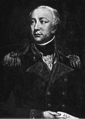
An officer in the Royal Engineers, Colby overcame the loss of one hand in a shooting accident to begin in 1802 a lifelong connection with the Ordnance Survey. His most important work was the Survey of Ireland. He began planning this enormous enterprise in 1824 and directed it until 1846, in which year the final maps made by the survey were almost ready for issue. He was the inventor of the "Colby Bar" (a compensation bar), an apparatus used in base-measurements.[1]
Early life
He was the eldest child of Major Thomas Colby, Royal Marines (died 1813) and his wife, Cornelia Hadden, sister of James Murray Hadden. He was born at St. Margaret's-next-Rochester on 1 September 1784. Colby was brought up by his father's sisters at Rhosygilwen, near Rhoshill, Pembrokeshire, West Wales. He attended school at Northfleet, Kent, under William Crakelt. He went on to the Royal Military Academy, Woolwich and passed out for the Royal Engineers while still 16.[2]
Colby attracted the notice of Major William Mudge, director of the Ordnance Survey, who arranged in 1802 to have him attached to the Survey. His first task was sector observations made at Dunnose, Isle of Wight in the summer of 1802. In December 1803, when on duty at Liskeard, Colby met with an accident through the bursting of a pistol loaded with small shot with which he was practising, his left hand having to be amputated at the wrist and part of the gun being permanently lodged in the skull. In 1804 he was observing the pole star for azimuths at Beaumaris; in 1806 he was assisting Mudge in the measurement of a base-line on Rhuddlan Marsh, near St. Asaph and in astronomical observations in Delamere Forest, Cheshire and on the Yorkshire moors. Later he was selecting trigonometrical stations on the mountains in South Wales.[3]
The publication of the maps themselves was suspended during the Napoleonic wars. In July 1809, Mudge was appointed lieutenant governor of the Royal Military Academy, Woolwich and Colby became the chief executive officer of the Survey.[3]
Scottish survey
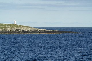
In 1813 it was decided to extend the measurement of the meridional line between Dunnose and the mouth of the River Tees into Scotland, with a mineralogical survey being carried out by John MacCulloch. In that and the following year Colby and his chief assistant, James Gardner, were selecting stations in the south-west of Scotland, and observing from them by theodolite. In 1815 Colby worked from Tower map office, but in 1816–17 he was again in the field, carrying the triangulation round the eastern coast towards Orkney and Shetland, and in the latter year, in conjunction with Gardner, measured the base-line of Belhelvie Links, near Aberdeen, the only base-line in Scotland. He was also engaged in observations in Shetland with Jean-Baptiste Biot, who had been deputed by the Institut de France to make pendulum and other observations there in connection with the prolongation of the arc of the meridian. Biot and Colby fell out, however.[3][4]
The survey required detailed measurements to be made at each location, often over days or weeks as weather permitted. When working on remote hills, Colby and his men built structures from local stone or turf to provide shelter. Some of these structures can still be seen on Scottish hills, where they are known as Colby camps or surveyors' camps.[5][6][7]
In London
Early in 1820 General Mudge died, and the Duke of Wellington appointed Colby to succeed him at the head of the Ordnance Survey. On 13 April 1820 Colby became a Fellow of the Royal Society. Later in the same year Lord Melville nominated him to a seat on the Board of Longitude, which he retained until it was dissolved in 1828. He also became an associate and then an honorary member of the Institution of Civil Engineers. At this time living in London, he was among the proprietors of the London Institute, and was one of the early members of the Athenaeum Club. He was also one of the founders of the Royal Astronomical Society, and with Mark Beaufoy, Olinthus Gregory, Edward Troughton, and others, drew up its rules.[3]
There was a pause the mountain work of the survey; but in 1821 Colby was employed in making observations in Orkney and Shetland, and on Faira and Foula; and in 1821-3 he was sent by the Royal Society with Henry Kater to co-operate with Arago and Claude-Louis Mathieu for the Institut de France, in connecting the observations of Greenwich and Paris. The results were published in Philosophical Transactions for 1828. Fresnel's new compound lenses were used for the observations across the English Channel. Colby gave his notes on them to his friend Robert Stevenson, leading to their adoption in British lighthouses.[3]
In 1824 Colby and the Ordnance Survey were given the task of surveying Ireland. He also decided to have the work carried on under direct official supervision, and raised three companies of sappers and miners to be trained in survey duties. Later many Irish surveyors were used. It began with Colby and a small party of sappers on Divis near Belfast, in 1825. He devised a dual arrangement of brass and iron, called by him a "compensation bar", which as the "Colby bar" was used base-measurements in all parts of the world. A base-line, eight miles long, was measured under his superintendence, on the southern side of Lough Foyle, in 1827–8. When the standard yard was destroyed in the 1834 Burning of Parliament, it was restored by going back to Colby's work.[3]
Initially trained staff were in short supply, and progress was slow. A committee headed by Sir James Carmichael Smyth recommended more rapid, but less accurate methods. This approach was abandoned in 1832. In May 1833 the publication of the first Irish county—Londonderry—in fifty sheets, took place. Other counties followed, and the completion of the map in 1847 saw 1,939 sheets, surveyed and plotted on a scale of six inches to the mile. Colby exceeded by large sums the budgets sanctioned by parliament, and forwent his own salary. The survey included a series of tidal observations. Colby during its progress introduced electrotyping, contour lines on the six-inch maps, and the training of picked men of the sappers and miners as surveyors.[3]
Later life
In 1833, Henry De la Beche suggested a geological map of the west of England, which was handed over by the government to Colby. The arrangement continued in force until 1845, when the geological survey was transferred to the Department of Woods and Forests. Apart from this project, and the publication of the sheets of the one-inch ordnance map of England and Wales, the operations of the British survey were at a standstill after the death of Mudge until 1838, when the survey of Scotland was resumed, and Colby moved back from Dublin to London. In that year he went back into the field for the last time, on Ben Hutig in Sutherlandshire.
In 1840, the government agreed to survey the remaining six counties in England (Lancashire, Yorkshire, Cumberland, Westmoreland, Durham, and Northumberland) and the whole of Scotland, on the six-inch scale, while the publication of the one-inch map continued for the rest of England. The assistants employed on the Irish survey were gradually transferred to England and Scotland. The work was proceeding slowly when, in November 1846, just as the sheets of the last Irish county were preparing for issue, Colby attained the rank of major-general, and in accordance with the rule of the service was retired from the post he had so long held.[3]
Colby devoted himself to the education of his sons, residing for some time at Bonn. He died at New Brighton, on 9 October 1852, aged 68. A monument was erected to him in St James Cemetery, Liverpool.[3]
Works
In 1811 appeared the third volume of the Trigonometrical Survey,[8] by Mudge and Colby.[3]
Family
In 1828 Colby married Elizabeth Hester Boyd, second daughter of Archibald Boyd of Londonderry. They had a family of four sons and three daughters. After his marriage Colby moved from London to Dublin, residing at first in Merrion Square, and afterwards at Knockmaroon Lodge, at the gates of Phoenix Park, within easy distance of the survey office, which was established in the old Mountjoy barracks.[3]
Legacy
Colby House, which was the headquarters of the OS Northern Ireland until 2014, is named in his honour.
Related Research Articles
Balta is an uninhabited island in Shetland, Scotland.
Major-General William Roy was a Scottish military engineer, surveyor, and antiquarian. He was an innovator who applied new scientific discoveries and newly emerging technologies to the accurate geodetic mapping of Great Britain. His masterpiece is usually referred to as Roy's Map of Scotland.
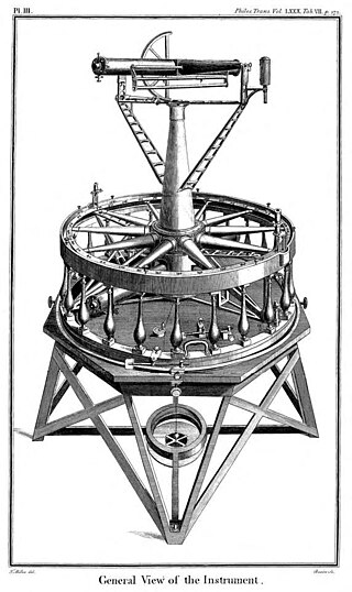
The Ramsden surveying instruments are those constructed by Jesse Ramsden and used in high precision geodetic surveys carried out in the period 1784 to 1853. This includes the five great theodolites—great in name, great in size and great in accuracy—used in surveys of Britain and other parts of the world. Ramsden also provided the equipment used in the measurement of the many base lines of these surveys and also the zenith telescope used in latitude determinations.
The Principal Triangulation of Britain was the first high-precision triangulation survey of the whole of Great Britain and Ireland, carried out between 1791 and 1853 under the auspices of the Board of Ordnance. The aim of the survey was to establish precise geographical coordinates of almost 300 significant landmarks which could be used as the fixed points of local topographic surveys from which maps could be drawn. In addition there was a purely scientific aim in providing precise data for geodetic calculations such as the determination of the length of meridian arcs and the figure of the Earth. Such a survey had been proposed by William Roy (1726–1790) on his completion of the Anglo-French Survey but it was only after his death that the Board of Ordnance initiated the trigonometric survey, motivated by military considerations in a time of a threatened French invasion. Most of the work was carried out under the direction of Isaac Dalby, William Mudge and Thomas Frederick Colby, but the final synthesis and report (1858) was the work of Alexander Ross Clarke. The survey stood the test of time for a century, until the Retriangulation of Great Britain between 1935 and 1962.
Ordnance Survey Ireland was the national mapping agency of the Republic of Ireland. It was established on 4 March 2002 as a body corporate. It was the successor to the former Ordnance Survey of Ireland. It and the Ordnance Survey of Northern Ireland (OSNI) were themselves the successors to the Irish operations of the British Ordnance Survey. OSI was part of the Irish public service. OSI was headquartered at Mountjoy House in the Phoenix Park in Dublin, which had previously been the headquarters of the British Ordnance Survey in Ireland until 1922.
Major-General Joseph Ellison Portlock was born at Gosport and was a British geologist and soldier, the only son of Nathaniel Portlock, and a captain in the Royal Navy.
Colonel Sir Charles Frederick Arden-Close, was a British geographer and surveyor. He was Director General of the Ordnance Survey from 1911 to 1922. His insistence on attention to detail saw the improvement of many attitudes and methods at the Ordnance Survey. Close's planning saw the production of many maps now viewed as pinnacles in the classic period of map making. He was born Charles Frederick Close and changed his surname to Arden-Close in 1938 so as to comply with a bequest.
Major-General Sir Thomas Aiskew Larcom, Bart, PC FRS was a leading official in the early Irish Ordnance Survey. He later became a poor law commissioner, census commissioner and finally executive head of the British administration in Ireland as under-secretary to the Lord-Lieutenant of Ireland, a position the government of the day was eager for him to take.
Lieutenant Colonel William Yolland CB, FRS FRSA was an English military surveyor, astronomer and engineer, and was Britain's Chief Inspector of Railways from 1877 until his death. He was a redoubtable campaigner for railway safety, often in the face of strong opposition, at a time when railway investment was being directed towards the expansion of the networks rather than the prevention of accidents. He was a member of the three-man committee of inquiry into the Tay Bridge disaster.
Col Alexander Ross Clarke FRS FRSE (1828–1914) was a British geodesist, primarily remembered for his calculation of the Principal Triangulation of Britain (1858), the calculation of the Figure of the Earth and one of the most important text books of Geodesy (1880). He was an officer of the Royal Engineers employed on the Ordnance Survey.
The Ordnance Survey (OS) is the national mapping agency for Great Britain. The agency's name indicates its original military purpose, which was to map Scotland in the wake of the Jacobite rising of 1745. There was also a more general and nationwide need in light of the potential threat of invasion during the Napoleonic Wars. Since 1 April 2015, the Ordnance Survey has operated as Ordnance Survey Ltd, a government-owned company, 100% in public ownership. The Ordnance Survey Board remains accountable to the Secretary of State for Science, Innovation and Technology. It was also a member of the Public Data Group.
Colonel Robert Kearsley Dawson was an English surveyor and cartographer of the Corps of Royal Engineers.
William Mudge (1762–1820) was an English artillery officer and surveyor, born in Plymouth, an important figure in the work of the Ordnance Survey.
Christopher (1786–1855) and John Greenwood (1791–1840) were brother cartographers who produced large-scale maps of England and Wales in the 1820s.
Dunnose is a cape on the Isle of Wight in the English Channel. The headland is visible from well out to sea, and is used in navigation. It has twice been used as the base point for a triangulation of Great Britain. The line of accurately surveyed points running north from Dunnose to Clifton in Yorkshire provide the basis for triangulation to determine the positions of all other locations in Britain.
Richard Zachariah Mudge (1790–1854) was an English officer of the Royal Engineers, known as a surveyor.
The Anglo-French Survey (1784–1790) was the geodetic survey to measure the relative position of the Royal Greenwich Observatory and the Paris Observatory via triangulation. The English operations, executed by William Roy, consisted of the measurements of bases at Hounslow Heath (1784) and Romney Marsh (1787), the measurements of the angles of the triangles (1787–1788) and finally the calculation of all the triangles (1788–1790). The survey is very significant as the first precise survey within Britain, and the forerunner of the work of the Ordnance Survey which was founded in 1791, one year after Roy's death.
Major General Thomas Bernard Collinson was an English military engineer of the Corps of Royal Engineers who carried out the earliest British surveys of Hong Kong, and planned roads and other early military and civil engineering works in New Zealand. Immediately prior to retirement, he was architect to the Scottish Prison Commission.
James Gardner was an English surveyor, lithographer, cartographer, engraver and publisher who played an active role in the trigonometrical survey of Great Britain. His career spanned the years 1808 to 1840.
George Thomas was a Master in the Royal Navy who was one of the early surveyors of the coasts of Great Britain
↑ His commissions were as follows: second lieutenant royal engineers, 2 July 1801; first lieutenant, 6 August 1802; captain (second), 1 July 1807; brevet major, 19 July 1821; regimental lieutenant-colonel, 29 July 1825; regimental colonel, 10 January 1837; major-general, 9 November 1846.
↑ Trigonometrical Survey of England—An Account of the Trigonometrical Survey extending over the period 1800–1809. By Lieut.-colonel Mudge, Royal Artillery, and Capt. Colby, Royal Engineers.
This page is based on this Wikipedia article Text is available under the CC BY-SA 4.0 license; additional terms may apply. Images, videos and audio are available under their respective licenses.