Cartography of India

Last updated

The cartography of India begins with early charts for navigation [1] and constructional plans for buildings. [2] Indian traditions influenced Tibetan [3] and Islamic traditions, [4] and in turn, were influenced by the British cartographers who solidified modern concepts into India's map making. [5]

Contents

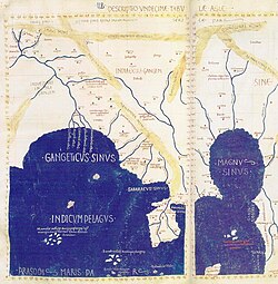
A prominent foreign geographer and cartographer was Hellenistic geographer Ptolemy (90–168) who researched at the library in Alexandria to produce a detailed eight-volume record of world geography. [5] During the Middle Ages, India sees some exploration by Chinese and Muslim geographers, while European maps of India remain very sketchy. A prominent medieval cartographer was Persian geographer Abu Rayhan Biruni (973–1048) who visited India and studied the country's geography extensively. [6]

European maps become more accurate with the Age of Exploration and Portuguese India from the 16th century. The first modern maps were produced by the Survey of India, established in 1767 by the British East India Company. The Survey of India remains in continued existence as the official mapping authority of the Republic of India.

Prehistory

Joseph E. Schwartzberg (2008) proposes that the Bronze Age Indus Valley civilization (c. 2500–1900 BCE) may have known "cartographic activity" based on a number of excavated surveying instruments and measuring rods and that the use of large scale constructional plans, cosmological drawings, and cartographic material was known in India with some regularity since the Vedic period (1st millennium BCE).[ clarification needed ] [7]

'Though not numerous, a number of map-like graffiti appear among the thousands of Stone Age Indian cave paintings; and at least one complex Mesolithic diagram is believed to be a representation of the cosmos.' [8]

Susan Gole (1990) comments on the cartographic traditions in early India:

The fact that towns as far apart as Mohenjodaro near the Indus and Lothal on the Saurashtra coast were built in the second millennium BCE with baked bricks of identical size on similar plans denotes a widespread recognition of the need for accuracy in planning and management. In the 8th century CE the Kailas temple at Ellora in Maharashtra was carved down into mountain for 100 feet, with intricate sculptures lining pillared halls, no easy task even with an exact map to follow, impossible without. So if no maps have been found, it should not be assumed that the Indians did not know how to conceptualize in a cartographic manner. [2]

Antiquity

Southeast Asia in a Renaissance map constructed after Ptolemy's Geography, rediscovered by Maximus Planudes in Constantinople c. 1300. Ptolemy Asia detail.jpg
Southeast Asia in a Renaissance map constructed after Ptolemy's Geography , rediscovered by Maximus Planudes in Constantinople c.1300.

Cartography of India as a part of the greater continent of Asia developed in Classical Antiquity.

In Greek cartography, India appears as a remote land on the eastern fringe of Asia in the 5th century BCE (Hecataeus of Miletus). More detailed knowledge becomes available after the conquests of Alexander the Great, and the 3rd-century BCE geographer Eratosthenes had a clearer idea of the size and location of India. By the 1st century, at least the western coast of India was well known to Hellenistic geography, with itineraries such as the Periplus of the Erythraean Sea. Marinus and Ptolemy had some knowledge of the Indian Ocean (which they considered a sea) but their idea of the size of Taprobana (Sri Lanka) was vastly too large and the Indian peninsula much reduced. They also had little knowledge of the interior of the country.

Native Indian cartographic traditions before the Hellenistic period remain rudimentary. Early forms of cartography in India included legendary paintings; maps of locations described in Indian epic poetry, for example the Ramayana . [9] These works contained descriptions of legendary places, and often even described the nature of the mythological inhabitants of a particular location. [9] Early Indian cartography showed little knowledge of scale, the important parts of the map were shown to be larger than others (Gole 1990). Indian cartographic traditions also covered the locations of the Pole star, and other constellations of use. [1] These charts may have been in use by the beginning of the Common Era for purposes of navigation. [1] Other early maps in India include the Udayagiri wall sculpture—made under the Gupta empire in 400 CE—showing the meeting of the Ganges and the Yamuna. [10]

Middle Ages

The 8th-century poet and dramatist Bhavabhuti, in Act 1 of the Uttararamacarita, described paintings which indicated geographical regions. [11] In the 20th century, over 200 medieval Indian maps were studied in the compilation of a history of cartography. Also considered in the study were copper-plate text inscriptions on which the boundaries of land, granted to the Brahman priests of India by their patrons, were described in detail. [2] The descriptions indicated good geographical knowledge and in one case over 75 details of the land granted have been found. [2] The Chinese records of the Tang dynasty show that a map of the neighboring Indian region was gifted to Wang Hiuen-tse by its king. [12]

In the 9th century, Islamic geographers under Abbasid Caliph Al-Ma'mun improved on Ptolemy's work and depicted the Indian Ocean as an open body of water instead of a land-locked sea as Ptolemy had done. [13] The Iranian geographers Abū Muhammad al-Hasan al-Hamdānī and Habash al-Hasib al-Marwazi set the Prime Meridian of their maps at Ujjain, a centre of Indian astronomy. [14] In the early 11th century, the Persian geographer Abu Rayhan Biruni visited India and studied the country's geography extensively. [6] He was considered the most skilled when it came to mapping cities and measuring the distances between them, which he did for many cities in the western Indian subcontinent.[ citation needed ] He also wrote extensively on the geology of India. [15] In 1154, the Arab geographer Muhammad al-Idrisi included a section on the cartography and geography of India and its neighboring countries in his world atlas, Tabula Rogeriana . [16]

Italian scholar Francesco Lorenzo Pullè reproduced a number of Indian maps in his magnum opusLa Cartografia Antica dell'India. [11] Out these maps two have been reproduced using a manuscript of Lokaprakasa—originally compiled by the polymath Ksemendra (Kashmir, 11th century CE)—as a source. [11] The other manuscript, used as a source by Francesco Pullè, is titled Samgrahani. [11] The early volumes of the Encyclopædia Britannica also described cartographic charts made by the Dravidian people of India. [1] [17]

16th century Portuguese navigational chart of the region Asia oceania anonymous c1550.jpg
16th century Portuguese navigational chart of the region

The cartographic tradition of India influenced the map making tradition of Tibet, where maps of Indian origin have been discovered. [3] Islamic cartography was also influenced by the Indian tradition as a result of extensive contact. [4]

The Portuguese explorer Vasco da Gama reached the subcontinent on 20 May 1498, anchoring off Calicut, on Malabar Coast. He would, with other Portuguese, navigate and chart much of the sub-continents coast line, within decades. These charts were rapidly reproduced, and appeared in say the 1502 Cantino planisphere.

Mughal era

Map of the "Inhabited Quarter" by Sadiq Isfahani from Jaunpur c.1647. This was one of the only surviving Indian made maps. Map of the Inhabited Quarter.png
Map of the “Inhabited Quarter” by Sadiq Isfahani from Jaunpur c.1647. This was one of the only surviving Indian made maps.

Maps from the 1590 Ain-e-Akbari, a Mughal document detailing India's history and traditions, contain references to locations indicated in earlier Indian cartographic traditions. [11]

Through the 16th century European explorers, and traders, such as Jan Huygen van Linschoten ventured into the interior, from the growing number or European trading posts, and expanded on and refined the previous navigational charts, with geographic detail. A series of geographies published under the title Itinerario (later published as an English edition as Discours of Voyages into Y East & West Indies), appeared in 1596, and graphically displayed for the first time in Europe detailed maps of voyages to the East Indies, particularly India.

Map of Goa, in Linschoten's Itineraries, ca.1590 AMH-6577-KB Bird's eye view of the city of Goa.jpg
Map of Goa, in Linschoten's Itineraries, ca.1590

The seamless hollow Celestial globe was invented in Kashmir by Ali Kashmiri ibn Luqman in 998 AH (1589–90 CE), and twenty other such globes were later produced in Lahore and Kashmir during the Mughal Empire. [18] Before they were rediscovered in the 1980s, it was believed by modern metallurgists to be technically impossible to produce hollow metal globes without any seams, even with modern technology. [18] These Mughal metallurgists pioneered the method of lost-wax casting in order to produce these globes. [18]

The scholar Sadiq Isfahani of Jaunpur compiled an atlas of the parts of the world which he held to be 'suitable for human life'. [10] The 32 sheet atlas—with maps oriented towards the south as was the case with Islamic works of the era—is part of a larger scholarly work compiled by Isfahani during 1647 CE. [10] According to Joseph E. Schwartzberg (2008): 'The largest known Indian map, depicting the former Rajput capital at Amber in remarkable house-by-house detail, measures 661 × 645 cm. (260 × 254 in., or approximately 22 × 21 ft).' [19]

Colonial India

For contributing to geographical knowledge about Asia, the pundit (explorer) and cartographer Nain Singh Rawat (19th century CE) received a Royal Geographical Society gold medal in 1876. NainSingh.gif
For contributing to geographical knowledge about Asia, the pundit (explorer) and cartographer Nain Singh Rawat (19th century CE) received a Royal Geographical Society gold medal in 1876.

A map describing the kingdom of Nepal, four feet in length and about two and a half feet in breadth, was presented to Warren Hastings. [9] In this raised-relief map the mountains were elevated above the surface and several geographical elements were indicated in different colors. [9] The Europeans used 'scale-bars' in their cartographic tradition. [2] Upon their arrival in India during the Middle Ages, the indigenous Indian measures were reported back to Europe, and first published by Guillaume de I'Isle in 1722 as Carte des Costes de Malabar et de Coromandel. [2]

With the establishment of the British Raj in India, modern European cartographic traditions were officially employed by the British Survey of India (1767). One British observer commented on the tradition of native Indian cartography:

Besides geographical tracts, the Hindus have also maps of the world according to the system of the puranics and of the astronomers: the latter are very common. They also have maps of India and of particular districts, in which latitudes and longitudes are entirely out of question, and they never make use of scale of equal parts. The sea shores, rivers and ranges of mountains are represented by straight lines. [9]

The Great Trigonometric Survey, a project of the Survey of India throughout most of the 19th century, was piloted in its initial stages by William Lambton, and later by George Everest. To achieve the highest accuracy a number of corrections were applied to all distances calculated from simple trigonometry:

Thomas George Montgomerie organized several cartographic expeditions to map Tibet, as well as China. [20] Mohamed-i-Hameed, Nain Singh and Mani Singh were among the agents employed by the British for their cartographic operations. [20] Nain Singh, in particular, became famous for his geographical knowledge of Asia, and was awarded several honors for his expeditions. [21]

Modern India (1947 to present)

The modern map making techniques in India, like other parts of the world, employ digitization, photographic surveys and printing. [22] Satellite imageries, aerial photographs and video surveying techniques are also used. [22] The Indian IRS-P5 (CARTOSAT-1) was equipped with high resolution panchromatic equipment to enable it for cartographic purposes. [23] IRS-P5 (CARTOSAT-1) was followed by a more advanced model named IRS-P6 developed also for agricultural applications. [23] The CARTOSAT-2 project, equipped with single panchromatic camera which supported scene specific on-spot images, succeed the CARTOSAT-1 project. [23]

See also

Notes

  1. 1 2 3 4 Sircar, 330
  2. 1 2 3 4 5 6 Gole (1990)
  3. 1 2 Sircar, 329
  4. 1 2 Pinto (2006)
  5. 1 2 Fuechsel (2008)
  6. 1 2 O'Connor, John J.; Robertson, Edmund F., "Abu Arrayhan Muhammad ibn Ahmad al-Biruni", MacTutor History of Mathematics Archive , University of St Andrews
  7. Schwartzberg, 1301–1302
  8. Schwartzberg, 1301
  9. 1 2 3 4 5 Sircar, page 327
  10. 1 2 3 Schwartzberg, 1302
  11. 1 2 3 4 5 Sircar, 328
  12. Sircar, 326.
  13. Covington (2007)
  14. Kennedy, 189
  15. Salam (1984)
  16. See Ahmad, S. Maqbul (1960), Al-Sharif al-Idrisi: India and the Neighbouring Territories
  17. See Encyclopædia Britannica, 14th edition, volume XIV, 840–841.
  18. 1 2 3 Savage-Smith (1985)
  19. Schwartzberg, 1303
  20. 1 2 Nagendra (1999)
  21. In 1876, his achievements were announced in the Geographical Magazine. The awards and recognition soon started flowing in. On his retirement, the Indian Government honoured him with the grant of a village, and 1000 rupees in revenue. The crowning achievement came in 1876, when the Royal Geographical Society honoured him with a gold medal as the ‘man who has added a greater amount of positive knowledge to the map of Asia than any individual of our time—Nagendra 1999.
  22. 1 2 See Indian Express (1999). Modern map-making techniques on display. Indian Express Newspapers (Bombay) Ltd. [ permanent dead link ]
  23. 1 2 3 Burleson, D. (2005), "India", Space Programs Outside the United States: All Exploration and Research Efforts, Country by Country, McFarland, 136–146, ISBN   0-7864-1852-4.

Related Research Articles

<span class="mw-page-title-main">Cartography</span> Study and practice of making maps

Cartography is the study and practice of making and using maps. Combining science, aesthetics and technique, cartography builds on the premise that reality can be modeled in ways that communicate spatial information effectively.

<span class="mw-page-title-main">Science in the medieval Islamic world</span> Science developed and practised during the Islamic Golden Age

Science in the medieval Islamic world was the science developed and practised during the Islamic Golden Age under the Abbasid Caliphate of Baghdad, the Umayyads of Córdoba, the Abbadids of Seville, the Samanids, the Ziyarids and the Buyids in Persia and beyond, spanning the period roughly between 786 and 1258. Islamic scientific achievements encompassed a wide range of subject areas, especially astronomy, mathematics, and medicine. Other subjects of scientific inquiry included alchemy and chemistry, botany and agronomy, geography and cartography, ophthalmology, pharmacology, physics, and zoology.

al-Biruni 11th-century Persian scholar and polymath

Abu Rayhan Muhammad ibn Ahmad al-Biruni, known as al-Biruni, was a Khwarazmian Iranian scholar and polymath during the Islamic Golden Age. He has been called variously the "founder of Indology", "Father of Comparative Religion", "Father of modern geodesy", and the first anthropologist.

<span class="mw-page-title-main">Kuninda Kingdom</span> Ancient Hindu dynasty of India

The Kingdom of Kuninda was an ancient central Himalayan kingdom documented from around the 2nd century BCE to the 3rd century, located in the southern areas of modern Himachal Pradesh and far western areas of Uttarakhand in northern India and Doti Gadwall in Nepal.

The history of geography includes many histories of geography which have differed over time and between different cultural and political groups. In more recent developments, geography has become a distinct academic discipline. 'Geography' derives from the Greek γεωγραφία – geographia, literally "Earth-writing", that is, description or writing about the Earth. The first person to use the word geography was Eratosthenes. However, there is evidence for recognizable practices of geography, such as cartography, prior to the use of the term.

<span class="mw-page-title-main">History of science and technology on the Indian subcontinent</span> Overview of science and technology developed on the Indian subcontinent

The history of science and technology on the Indian subcontinent begins with the prehistoric human activity of the Indus Valley Civilisation to the early Indian states and empires.

The earliest known world maps date to classical antiquity, the oldest examples of the 6th to 5th centuries BCE still based on the flat Earth paradigm. World maps assuming a spherical Earth first appear in the Hellenistic period. The developments of Greek geography during this time, notably by Eratosthenes and Posidonius culminated in the Roman era, with Ptolemy's world map, which would remain authoritative throughout the Middle Ages. Since Ptolemy, knowledge of the approximate size of the Earth allowed cartographers to estimate the extent of their geographical knowledge, and to indicate parts of the planet known to exist but not yet explored as terra incognita.

<span class="mw-page-title-main">Shaka era</span> Hindu calendar era

The Shaka era is a historical Hindu calendar era, the epoch of which corresponds to Julian year 78.

<i>Geography</i> (Ptolemy) Treatise on cartography by Claudius Ptolemaeus

The Geography, also known by its Latin names as the Geographia and the Cosmographia, is a gazetteer, an atlas, and a treatise on cartography, compiling the geographical knowledge of the 2nd-century Roman Empire. Originally written by Claudius Ptolemy in Greek at Alexandria around AD 150, the work was a revision of a now-lost atlas by Marinus of Tyre using additional Roman and Persian gazetteers and new principles. Its translation into Arabic in the 9th century was highly influential on the geographical knowledge and cartographic traditions of the Islamic world. Alongside the works of Islamic scholars – and the commentary containing revised and more accurate data by Alfraganus – Ptolemy's work was subsequently highly influential on Medieval and Renaissance Europe.

Joseph E. Schwartzberg was an American writer, peace activist, and a world federalist, who was a tenured professor at the University of Minnesota. Author of numerous books, he was the editor and principal author of the Historical Atlas of South Asia, which in 1980 won the Watumull Prize of the American Historical Association. In 1984 the American Association of Geographers honored him with their annual award. His several substantial chapters in Book One of Volume Two of The History of Cartography were instrumental in that work receiving the R. R. Hawkins Award for Best Scholarly Book for 1992 from the Association of American Publishers. He served on the board of directors of the World Federalist Association, has chaired its Policy and Issues Commission, and is President of the Minnesota chapter of Citizens for Global Solutions.

The history of cartography refers to the development and consequences of cartography, or mapmaking technology, throughout human history. Maps have been one of the most important human inventions for millennia, allowing humans to explain and navigate their way through the world.

The Malavas or Malwas were an ancient Indian tribe. Modern scholars identify them with the Mallian people (Malloi) who were settled in the Punjab region at the time of Alexander's invasion in the 4th century BCE. Later, the Malavas migrated southwards to present-day Rajasthan, and ultimately to Madhya Pradesh and Gujarat. Their power gradually declined as a result of defeats against the Western Satraps, the Gupta emperor Samudragupta, and the Chalukya emperor Pulakeshin II.

Medieval Islamic geography and cartography refer to the study of geography and cartography in the Muslim world during the Islamic Golden Age. Muslim scholars made advances to the map-making traditions of earlier cultures, particularly the Hellenistic geographers Ptolemy and Marinus of Tyre, combined with what explorers and merchants learned in their travels across the Old World (Afro-Eurasia). Islamic geography had three major fields: exploration and navigation, physical geography, and cartography and mathematical geography. Islamic geography reached its apex with Muhammad al-Idrisi in the 12th century.

<span class="mw-page-title-main">Cartography of Asia</span> Overview of the cartography of Asia

The cartography of Asia can refer to the representation of Asia on a map, or to depictions of the world by cartographers from Asia. Depictions of portions of Asia have existed on maps as early as the 6th century BCE, with maps being drafted to depict the Babylonian, Hellenistic Greek, and Han dynasty empires.

<i>Tabula Rogeriana</i> Medieval map

The Nuzhat al-mushtāq fī ikhtirāq al-āfāq, commonly known in the West as the Tabula Rogeriana, is an atlas commissioned by the Norman King Roger II in 1138 and completed by the Arab geographer Muhammad al-Idrisi in 1154. The atlas compiles 70 maps of the known world with associated descriptions and commentary of each specific location by Al-Idrisi.

<span class="mw-page-title-main">Mahameghavahana dynasty</span> Ancient Indian dynasty

The Mahameghavahana dynasty was an ancient ruling dynasty of Kalinga after the decline of the Maurya Empire. In the first century B.C., Mahameghavahana, a king of Chedirastra conquered Kalinga and Kosala. During the reign of Kharavela, the third king of Mahameghavahana dynasty, South Kosala became an integral part of the kingdom. He patronised Jainism, but did not discriminate against other religions. He is known by his Hathigumpha inscription.

<span class="mw-page-title-main">Geography</span> Study of lands and inhabitants of Earth

Geography is the study of the lands, features, inhabitants, and phenomena of Earth. Geography is an all-encompassing discipline that seeks an understanding of Earth and its human and natural complexities—not merely where objects are, but also how they have changed and come to be. While geography is specific to Earth, many concepts can be applied more broadly to other celestial bodies in the field of planetary science. Geography has been called "a bridge between natural science and social science disciplines."

The Golden Age of Islam, which saw a flourishing of science, notably mathematics and astronomy, especially during the 9th and 10th centuries, had a notable Indian influence.

<span class="mw-page-title-main">Island of the Jewel</span> Semi-legendary island in medieval Arabic cartography

The Island of the Jewel or Island of Sapphires was a semi-legendary island in medieval Arabic cartography, said to lie in the Sea of Darkness near the equator, forming the eastern limit of the inhabited world. The island does not appear in any surviving manuscript of Ptolemy's Geography nor other Greek geographers. Instead, it is first attested in the Ptolemaic-influenced Book of the Description of the Earth compiled by al-Khwārizmī around 833. Ptolemy's map ended at 180° E. of the Fortunate Isles without being able to explain what might lay on the imagined eastern shore of the Indian Ocean or beyond the lands of Sinae and Serica in Asia. Roman missions subsequently reached the Han court via Longbian (Hanoi) and Chinese Muslims traditionally credit the founding of their community to the Companion Saʿd ibn Abi Waqqas as early as the 7th century. Muslim merchants such as Soleiman established sizable expatriate communities; a large-scale massacre of Arabs and Persians is recorded at Yangzhou in 760. These connections showed al-Khwārizmī and other Islamic geographers that the Indian Ocean was not closed as Hipparchus and Ptolemy had held but opened either narrowly or broadly.

The cartography of the region of Palestine, also known as cartography of the Holy Land and cartography of the Land of Israel, is the creation, editing, processing and printing of maps of the region of Palestine from ancient times until the rise of modern surveying techniques. For several centuries during the Middle Ages it was the most prominent subject in all of cartography, and it has been described as an "obsessive subject of map art".

References